Long Canyon Pass, Sec. 30, T63n, R2w To Forest Boundary, Road #417, Sec. 25, T63n, R2w River Run
Community Reviews
Been here? Share the conditions.
Reviews, ratings & photos are added in the free Snoflo iOS app — rate a spot, tag the conditions, and your visit is verified by location. Add or manage your reviews from the app.
Long Canyon Pass, Sec. 30, T63n, R2w To Forest Boundary, Road #417, Sec. 25, T63n, R2w
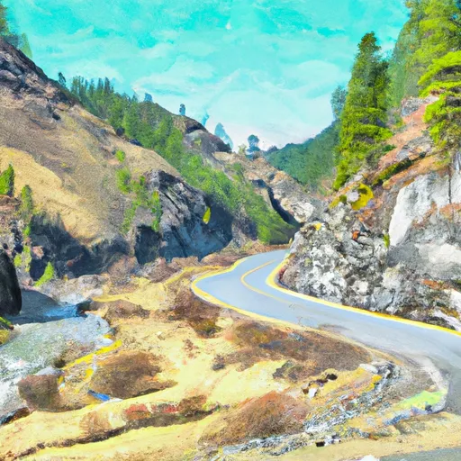
The run starts in Long Canyon Pass, Sec. 30, T63N, R2W and ends at the Forest Boundary, Road #417, Sec. 25, T63N, R2W. The segment is relatively short, but it offers challenging rapids and beautiful scenery.
There are some specific regulations to keep in mind when planning a trip to this area. A permit is required to launch a raft or kayak on the river, and all boaters must have proper safety equipment, including a personal flotation device (PFD) and a helmet. It is also important to note that the river runs through private property, so it is important to respect landowner rights and avoid trespassing.
Overall, the Whitewater River Run in Idaho is a challenging and exciting river run for experienced whitewater paddlers. It is important to check streamflow levels and follow all regulations before embarking on this adventure.
Plan your run down to the hour
Same weather feed Snoflo's iOS app uses -- updated continuously from NOAA / yr.no. Watch the precipitation column on the meteogram; rain ahead of a run typically lifts flows 12-48 hours later depending on the basin.
Next 5 days, hour by hour
Temperature line with weather symbols on top, snow + rain accumulation as columns, humidity as a dotted line.
5-day forecast table
Every 3 hours, broken out across temperature, snow, rain, humidity, and wind. Each cell is colour-coded relative to the column min/max.
| Time | Condition | Temp (°F) | Snow (in) | Rain (in) | Humidity (%) | Wind (mps) | Wind dir |
|---|---|---|---|---|---|---|---|
| Loading detailed forecast… | |||||||
15-day temperature & precipitation
Daily temperatures, snow, and rain projected over the next two weeks -- the upstream story that drives next week's flows.
Regional streamflow levels
USGS streamgauges around Long Canyon Pass, Sec. 30, T63n, R2w To Forest Boundary, Road #417, Sec. 25, T63n, R2w -- useful for spotting upstream pulses and gauging which tributary is contributing what.
| Streamgauge | Discharge | View |
|---|---|---|
| Boundary Creek Nr Porthill Id | 27 cfs | → |
| Kootenai River At Porthill Id | 9,860 cfs | → |
| Moyie River At Eastport Id | 96 cfs | → |
| Kootenai River @ Tribal Hatchery Nr Bonners Ferry | 15,700 cfs | → |
| Kootenai River Bel Moyie River Nr Bonners Ferry Id | 9,840 cfs | → |
| Kootenai River At Leonia Id | 9,690 cfs | → |
Plan a longer trip
The closest boat launches, other paddle runs, and campgrounds so a day on the water can grow into a full weekend.
Boat launches
- Tavern Farm Road 15, Boundary County
- Copeland
- Kootenay River Road Area C
- Brush Lake
- Smith Lake
- Deep Creek
Other river runs
- Upper Priest River
- Segment 2 Flows For Almost 10 Miles From The Intersection With Trail 312 To Its Confluence With The Upper Priest River To Segment 2 Flows For Almost 10 Miles From The Intersection With Trail 312 To Its Confluence With The Upper Priest River
- Segment 1 Is Classified As Wild And Flows From Its Source For Almost Five Miles To The Intersection With Trail 312 To Segment 1 Is Classified As Wild And Flows From Its Source For Almost To The Intersection With Trail 312
- Ne1/4 Of Sec 13, T40n, R46e To Nw1/4 Of Sec 5, T40n, R46e
- Kootenai River
Whitewater safety
- Check the flow before you run
- Use the linked-gauge card and Regional Flow panel above. Class ratings change with flow -- a Class III at low water can become Class IV+ at high water.
- Know your skill ceiling
- Pick runs comfortably below your ceiling. Cold-water and big-water runs raise the consequences of any mistake.
- Wear the right gear
- Helmet, PFD, drysuit / wetsuit when water is below 60°F. Throw bag, knife, and whistle on your person, not in the boat.
- Scout, set safety, and run with a team
- Scout new rapids on foot, set safety with throw bags above the consequence pool, and run with at least one other competent paddler.
- Respect the river
- Strainers, undercuts, low-head dams, and wood can kill at any class rating. When in doubt, portage.
Set push alerts in the Snoflo app
Save Long Canyon Pass, Sec. 30, T63n, R2w To Forest Boundary, Road #417, Sec. 25, T63n, R2w as a favorite, set a discharge threshold (e.g. "alert me when flow hits 600 cfs"), and the iOS app pushes the moment the linked gauge crosses.
About Long Canyon Pass, Sec. 30, T63n, R2w To Forest Boundary, Road #417, Sec. 25, T63n, R2w
What's the optimal flow for Long Canyon Pass, Sec. 30, T63n, R2w To Forest Boundary, Road #417, Sec. 25, T63n, R2w?
The optimal flow depends on the section and the craft. Check the Run Details panel for the linked gauge and current status.
How fresh is the cfs reading on this page?
The linked USGS streamgauge reports continuously (every 15 minutes); Snoflo refreshes throughout the day. Hover the streamflow sparkline to read individual datapoints.
What's the whitewater class?
See the Run Details panel for the class rating Snoflo tracks for this run. Class ratings change with flow -- a Class III at low water can become Class IV in high water.
Where do I put in / take out?
Tap Directions in the hero above to open driving directions to the put-in. For shuttle planning, check the Nearby Boat Launches panel and the river run operator's site.
Can I get alerts when flows hit the optimal range?
Yes -- alerts are managed in the Snoflo iOS app. Favorite this run, set a discharge threshold, and you'll get a push the moment the gauge crosses.
Other runs near here
Snoflo-tracked paddle runs within driving distance of Long Canyon Pass, Sec. 30, T63n, R2w To Forest Boundary, Road #417, Sec. 25, T63n, R2w.