South Fork Clearwater River, Sec. 30, T29n, R5e To Headwaters River Run
Community Reviews
Been here? Share the conditions.
Reviews, ratings & photos are added in the free Snoflo iOS app — rate a spot, tag the conditions, and your visit is verified by location. Add or manage your reviews from the app.
South Fork Clearwater River, Sec. 30, T29n, R5e To Headwaters
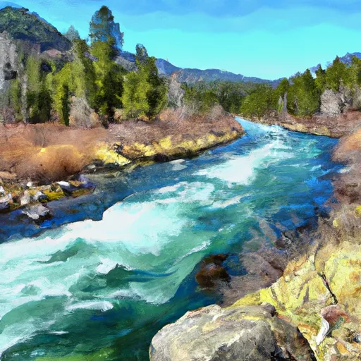
The segment mileage for this river run is approximately 47 miles, starting at Section 30, T29N, R5E and ending at the headwaters. Some of the notable rapids on the South Fork Clearwater River include Four Corners, Mile Long, and Schoolhouse. The river also has several boulder gardens and technical sections that require paddlers to navigate with precision.
It is important to note that there are specific regulations in place for the South Fork Clearwater River. For instance, commercial outfitters are required to have permits to operate on the river, and private boaters are required to obtain a permit as well. Additionally, there are restrictions on the use of motorized boats, and certain portions of the river are closed to boating during certain times of the year to protect fish habitat.
Overall, the South Fork Clearwater River is a challenging and exciting whitewater run that requires experienced paddlers to navigate safely. With the right conditions and careful planning, it can provide an unforgettable adventure for those who are up for the challenge.
Plan your run down to the hour
Same weather feed Snoflo's iOS app uses -- updated continuously from NOAA / yr.no. Watch the precipitation column on the meteogram; rain ahead of a run typically lifts flows 12-48 hours later depending on the basin.
Next 5 days, hour by hour
Temperature line with weather symbols on top, snow + rain accumulation as columns, humidity as a dotted line.
5-day forecast table
Every 3 hours, broken out across temperature, snow, rain, humidity, and wind. Each cell is colour-coded relative to the column min/max.
| Time | Condition | Temp (°F) | Snow (in) | Rain (in) | Humidity (%) | Wind (mps) | Wind dir |
|---|---|---|---|---|---|---|---|
| Loading detailed forecast… | |||||||
15-day temperature & precipitation
Daily temperatures, snow, and rain projected over the next two weeks -- the upstream story that drives next week's flows.
Regional streamflow levels
USGS streamgauges around South Fork Clearwater River, Sec. 30, T29n, R5e To Headwaters -- useful for spotting upstream pulses and gauging which tributary is contributing what.
| Streamgauge | Discharge | View |
|---|---|---|
| Sf Clearwater River Nr Elk City Id | 42 cfs | → |
| Sf Clearwater River At Stites Id | 187 cfs | → |
| Salmon River At White Bird Id | 5,360 cfs | → |
| Clear Ck At Kooskia National Fish Hatchery | 18 cfs | → |
| Selway River Nr Lowell Id | 1,140 cfs | → |
| Lochsa River Nr Lowell Id | 849 cfs | → |
Plan a longer trip
The closest boat launches, other paddle runs, and campgrounds so a day on the water can grow into a full weekend.
Other river runs
- Wilderness Boundary To Headwaters
- Gospel-Hump Wilderness Boundary To Headwaters Near Hump Lake
- Salmon River, Sec. 36, T27n, R1e To Gospel-Hump Wilderness Boundary, Sec. 31, T27n, R4e
- Hammer Creek To Heller Bar (Lower Salmon)
- Salmon River, Sec. 22, T28n, R1e To North And South Forks Of White Bird Creek
Whitewater safety
- Check the flow before you run
- Use the linked-gauge card and Regional Flow panel above. Class ratings change with flow -- a Class III at low water can become Class IV+ at high water.
- Know your skill ceiling
- Pick runs comfortably below your ceiling. Cold-water and big-water runs raise the consequences of any mistake.
- Wear the right gear
- Helmet, PFD, drysuit / wetsuit when water is below 60°F. Throw bag, knife, and whistle on your person, not in the boat.
- Scout, set safety, and run with a team
- Scout new rapids on foot, set safety with throw bags above the consequence pool, and run with at least one other competent paddler.
- Respect the river
- Strainers, undercuts, low-head dams, and wood can kill at any class rating. When in doubt, portage.
Set push alerts in the Snoflo app
Save South Fork Clearwater River, Sec. 30, T29n, R5e To Headwaters as a favorite, set a discharge threshold (e.g. "alert me when flow hits 600 cfs"), and the iOS app pushes the moment the linked gauge crosses.
About South Fork Clearwater River, Sec. 30, T29n, R5e To Headwaters
What's the optimal flow for South Fork Clearwater River, Sec. 30, T29n, R5e To Headwaters?
The optimal flow depends on the section and the craft. Check the Run Details panel for the linked gauge and current status.
How fresh is the cfs reading on this page?
The linked USGS streamgauge reports continuously (every 15 minutes); Snoflo refreshes throughout the day. Hover the streamflow sparkline to read individual datapoints.
What's the whitewater class?
See the Run Details panel for the class rating Snoflo tracks for this run. Class ratings change with flow -- a Class III at low water can become Class IV in high water.
Where do I put in / take out?
Tap Directions in the hero above to open driving directions to the put-in. For shuttle planning, check the Nearby Boat Launches panel and the river run operator's site.
Can I get alerts when flows hit the optimal range?
Yes -- alerts are managed in the Snoflo iOS app. Favorite this run, set a discharge threshold, and you'll get a push the moment the gauge crosses.
Other runs near here
Snoflo-tracked paddle runs within driving distance of South Fork Clearwater River, Sec. 30, T29n, R5e To Headwaters.