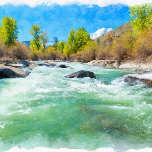
East Fork Shoofly Creek river run
Community Reviews
Been here? Share the conditions.
Reviews, ratings & photos are added in the free Snoflo iOS app — rate a spot, tag the conditions, and your visit is verified by location. Add or manage your reviews from the app.
East Fork Shoofly Creek
One of the main obstacles on this river is the "Big Kahuna" rapid, which is a Class IV rapid that requires sharp maneuvering and careful navigation. Other notable rapids include "The Slide," "The Waterfall," and "The Wave." It is important to note that while this river is relatively short, the rapids are intense, and proper safety precautions should be taken.
There are specific regulations in place for the East Fork Shoofly Creek. A permit is required to launch a raft or kayak, and all boaters are required to wear personal flotation devices (PFDs). Additionally, the river is only open for boating during certain times of the year, typically from mid-May through early July, due to low water levels in the late summer and fall months.
Overall, the East Fork Shoofly Creek is a challenging and exciting whitewater river run that attracts experienced rafters and kayakers from around the country. While it is important to follow safety regulations and use caution while navigating the rapids, the thrill and excitement of the ride make it well worth the effort.
Plan your run down to the hour
Same weather feed Snoflo's iOS app uses -- updated continuously from NOAA / yr.no. Watch the precipitation column on the meteogram; rain ahead of a run typically lifts flows 12-48 hours later depending on the basin.
Next 5 days, hour by hour
Temperature line with weather symbols on top, snow + rain accumulation as columns, humidity as a dotted line.
5-day forecast table
Every 3 hours, broken out across temperature, snow, rain, humidity, and wind. Each cell is colour-coded relative to the column min/max.
| Time | Condition | Temp (°F) | Snow (in) | Rain (in) | Humidity (%) | Wind (mps) | Wind dir |
|---|---|---|---|---|---|---|---|
| Loading detailed forecast… | |||||||
15-day temperature & precipitation
Daily temperatures, snow, and rain projected over the next two weeks -- the upstream story that drives next week's flows.
Regional streamflow levels
USGS streamgauges around East Fork Shoofly Creek -- useful for spotting upstream pulses and gauging which tributary is contributing what.
| Streamgauge | Discharge | View |
|---|---|---|
| Bruneau River Nr Hot Spring Id | 32 cfs | → |
| Snake River Nr Murphy Id | 4,100 cfs | → |
| Ef Owyhee River At Crutcher Crossing | 23 cfs | → |
| Canyon Cr At Oregon Trail Xing Nr Mountain Home Id | 1 cfs | → |
| Snake River At King Hill Id | 6,030 cfs | → |
| Sf Boise River At Anderson Ranch Dam Id | 1,580 cfs | → |
Plan a longer trip
The closest boat launches, other paddle runs, and campgrounds so a day on the water can grow into a full weekend.
Other river runs
Whitewater safety
- Check the flow before you run
- Use the linked-gauge card and Regional Flow panel above. Class ratings change with flow -- a Class III at low water can become Class IV+ at high water.
- Know your skill ceiling
- Pick runs comfortably below your ceiling. Cold-water and big-water runs raise the consequences of any mistake.
- Wear the right gear
- Helmet, PFD, drysuit / wetsuit when water is below 60°F. Throw bag, knife, and whistle on your person, not in the boat.
- Scout, set safety, and run with a team
- Scout new rapids on foot, set safety with throw bags above the consequence pool, and run with at least one other competent paddler.
- Respect the river
- Strainers, undercuts, low-head dams, and wood can kill at any class rating. When in doubt, portage.
Set push alerts in the Snoflo app
Save East Fork Shoofly Creek as a favorite, set a discharge threshold (e.g. "alert me when flow hits 600 cfs"), and the iOS app pushes the moment the linked gauge crosses.
About East Fork Shoofly Creek
What's the optimal flow for East Fork Shoofly Creek?
The optimal flow depends on the section and the craft. Check the Run Details panel for the linked gauge and current status.
How fresh is the cfs reading on this page?
The linked USGS streamgauge reports continuously (every 15 minutes); Snoflo refreshes throughout the day. Hover the streamflow sparkline to read individual datapoints.
What's the whitewater class?
See the Run Details panel for the class rating Snoflo tracks for this run. Class ratings change with flow -- a Class III at low water can become Class IV in high water.
Where do I put in / take out?
Tap Directions in the hero above to open driving directions to the put-in. For shuttle planning, check the Nearby Boat Launches panel and the river run operator's site.
Can I get alerts when flows hit the optimal range?
Yes -- alerts are managed in the Snoflo iOS app. Favorite this run, set a discharge threshold, and you'll get a push the moment the gauge crosses.
Other runs near here
Snoflo-tracked paddle runs within driving distance of East Fork Shoofly Creek.