Snake River River Run
Community Reviews
Been here? Share the conditions.
Reviews, ratings & photos are added in the free Snoflo iOS app — rate a spot, tag the conditions, and your visit is verified by location. Add or manage your reviews from the app.
Snake River
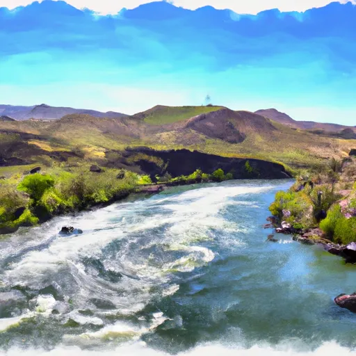
The Snake River run in Idaho covers a segment of approximately 30 miles, starting from the West Table Boat Ramp and ending at Sheep Gulch Boat Ramp. This section of the river is characterized by some of the most stunning scenery, including the Grand Teton Mountains and the Snake River Canyon.
Rapids such as Big Kahuna and Lunch Counter provide challenging obstacles to navigate, requiring technical skill and precision. Kayakers and rafters can also enjoy other rapids such as Ropes, Three Oar Deal, and The Notch.
It’s important to note that there are specific regulations in place to ensure the safety of all participants on the Snake River. For example, all participants must wear a personal flotation device (PFD) at all times, and all boats must have a throw bag and a first aid kit. Additionally, it’s recommended that all participants take a swiftwater rescue course before attempting this run.
Overall, the Snake River in Idaho is a thrilling and memorable whitewater experience for experienced rafters and kayakers. However, it’s important to be aware of the ideal streamflow range, class rating, segment mileage, specific river rapids/obstacles, and specific regulations to ensure a safe and enjoyable trip.
Plan your run down to the hour
Same weather feed Snoflo's iOS app uses -- updated continuously from NOAA / yr.no. Watch the precipitation column on the meteogram; rain ahead of a run typically lifts flows 12-48 hours later depending on the basin.
Next 5 days, hour by hour
Temperature line with weather symbols on top, snow + rain accumulation as columns, humidity as a dotted line.
5-day forecast table
Every 3 hours, broken out across temperature, snow, rain, humidity, and wind. Each cell is colour-coded relative to the column min/max.
| Time | Condition | Temp (°F) | Snow (in) | Rain (in) | Humidity (%) | Wind (mps) | Wind dir |
|---|---|---|---|---|---|---|---|
| Loading detailed forecast… | |||||||
15-day temperature & precipitation
Daily temperatures, snow, and rain projected over the next two weeks -- the upstream story that drives next week's flows.
Regional streamflow levels
USGS streamgauges around Snake River -- useful for spotting upstream pulses and gauging which tributary is contributing what.
| Streamgauge | Discharge | View |
|---|---|---|
| Snake River At King Hill Id | 6,000 cfs | → |
| N Channel Snake R @ Upper Salmon Falls Nr Hagerman | 79 cfs | → |
| Malad River Nr Gooding Id | 99 cfs | → |
| Salmon Falls Creek Nr Hagerman Id | 38 cfs | → |
| Snake River Nr Buhl Id | 1,610 cfs | → |
| Bruneau River Nr Hot Spring Id | 33 cfs | → |
Plan a longer trip
The closest boat launches, other paddle runs, and campgrounds so a day on the water can grow into a full weekend.
Boat launches
Other river runs
- Box Canyon
- Bruneau (Indian Hot Springs To Bruneau)
- Anderson Ranch Dam To Confluence With Mennecke Creek
Campgrounds
- Three Island Crossing State Park
- Emigrant Reservoir Dispersed Recreation Site
- Morrow Reservoir Dispersed Recreation Site
- Blair Trail Reservoir
Whitewater safety
- Check the flow before you run
- Use the linked-gauge card and Regional Flow panel above. Class ratings change with flow -- a Class III at low water can become Class IV+ at high water.
- Know your skill ceiling
- Pick runs comfortably below your ceiling. Cold-water and big-water runs raise the consequences of any mistake.
- Wear the right gear
- Helmet, PFD, drysuit / wetsuit when water is below 60°F. Throw bag, knife, and whistle on your person, not in the boat.
- Scout, set safety, and run with a team
- Scout new rapids on foot, set safety with throw bags above the consequence pool, and run with at least one other competent paddler.
- Respect the river
- Strainers, undercuts, low-head dams, and wood can kill at any class rating. When in doubt, portage.
Set push alerts in the Snoflo app
Save Snake River as a favorite, set a discharge threshold (e.g. "alert me when flow hits 600 cfs"), and the iOS app pushes the moment the linked gauge crosses.
About Snake River
What's the optimal flow for Snake River?
The optimal flow depends on the section and the craft. Check the Run Details panel for the linked gauge and current status.
How fresh is the cfs reading on this page?
The linked USGS streamgauge reports continuously (every 15 minutes); Snoflo refreshes throughout the day. Hover the streamflow sparkline to read individual datapoints.
What's the whitewater class?
See the Run Details panel for the class rating Snoflo tracks for this run. Class ratings change with flow -- a Class III at low water can become Class IV in high water.
Where do I put in / take out?
Tap Directions in the hero above to open driving directions to the put-in. For shuttle planning, check the Nearby Boat Launches panel and the river run operator's site.
Can I get alerts when flows hit the optimal range?
Yes -- alerts are managed in the Snoflo iOS app. Favorite this run, set a discharge threshold, and you'll get a push the moment the gauge crosses.
Other runs near here
Snoflo-tracked paddle runs within driving distance of Snake River.