Pittston Farm To Golden Road Bridge (Approx. 2 Miles Below Lobster Stream) River Run
Community Reviews
Been here? Share the conditions.
Reviews, ratings & photos are added in the free Snoflo iOS app — rate a spot, tag the conditions, and your visit is verified by location. Add or manage your reviews from the app.
Pittston Farm To Golden Road Bridge (Approx. 2 Miles Below Lobster Stream)
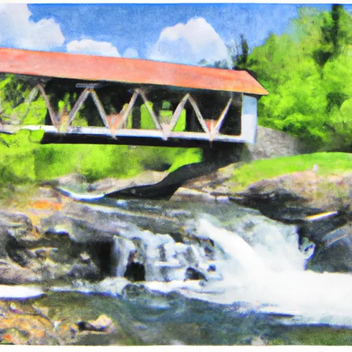
The river features various rapids and obstacles including the "Elephant Rock" rapid and "Big Mama" rapid which are both Class III rapids. There are also numerous boulder gardens and tight turns that require skilled paddling. The scenery along the way is breathtaking with views of the remote Maine wilderness and wildlife such as moose and bald eagles.
There are specific regulations to the area, including a daily use fee of $10 per person for those paddling on the river. Additionally, it is required that all paddlers wear a personal flotation device (PFD) while on the river and that no alcoholic beverages are consumed while paddling.
Sources such as the Maine Department of Agriculture, Conservation, and Forestry and American Whitewater have verified the accuracy of information regarding the Whitewater River Run. Overall, this is a challenging and rewarding river run for intermediate paddlers seeking an adventure in the remote Maine wilderness.
Plan your run down to the hour
Same weather feed Snoflo's iOS app uses -- updated continuously from NOAA / yr.no. Watch the precipitation column on the meteogram; rain ahead of a run typically lifts flows 12-48 hours later depending on the basin.
Next 5 days, hour by hour
Temperature line with weather symbols on top, snow + rain accumulation as columns, humidity as a dotted line.
5-day forecast table
Every 3 hours, broken out across temperature, snow, rain, humidity, and wind. Each cell is colour-coded relative to the column min/max.
| Time | Condition | Temp (°F) | Snow (in) | Rain (in) | Humidity (%) | Wind (mps) | Wind dir |
|---|---|---|---|---|---|---|---|
| Loading detailed forecast… | |||||||
15-day temperature & precipitation
Daily temperatures, snow, and rain projected over the next two weeks -- the upstream story that drives next week's flows.
Regional streamflow levels
USGS streamgauges around Pittston Farm To Golden Road Bridge (Approx. 2 Miles Below Lobster Stream) -- useful for spotting upstream pulses and gauging which tributary is contributing what.
| Streamgauge | Discharge | View |
|---|---|---|
| North Branch Penobscot River Nr Pittston Farm | 45 cfs | → |
| Kennebec River At The Forks | 438 cfs | → |
| Spencer Stream At Mouth | 41 cfs | → |
| Piscataquis River At Blanchard | 12 cfs | → |
| Dead River Near Dead River | 406 cfs | → |
| Kingsbury Stream At Abbot Village | 15 cfs | → |
Plan a longer trip
The closest boat launches, other paddle runs, and campgrounds so a day on the water can grow into a full weekend.
Boat launches
- Seboomook Lake
- Canada Falls Lake
- Maine
- Moosehead Lake
- Moosehead Lake (Norcross Brook)
- Kineo Dock Road Rockwood
Other river runs
- Canada Falls Lake To Pittston Farm
- Headwaters To Confluence With South Branch Penobscot River
- The North Branch Headwater From Canal Cut Approximately 1.25 Miles Upstream Of Big Bog To Pittston Farm
- Golden Road Bridge (Approx. 2 Miles Below Lobster Stream) To Confluence With Pine Stream
- The South Branch Headwater From Hilton Farm To Bridge At Upper End Of Canada Falls Lake; Also Penobscot Lake And Brook
Whitewater safety
- Check the flow before you run
- Use the linked-gauge card and Regional Flow panel above. Class ratings change with flow -- a Class III at low water can become Class IV+ at high water.
- Know your skill ceiling
- Pick runs comfortably below your ceiling. Cold-water and big-water runs raise the consequences of any mistake.
- Wear the right gear
- Helmet, PFD, drysuit / wetsuit when water is below 60°F. Throw bag, knife, and whistle on your person, not in the boat.
- Scout, set safety, and run with a team
- Scout new rapids on foot, set safety with throw bags above the consequence pool, and run with at least one other competent paddler.
- Respect the river
- Strainers, undercuts, low-head dams, and wood can kill at any class rating. When in doubt, portage.
Set push alerts in the Snoflo app
Save Pittston Farm To Golden Road Bridge (Approx. 2 Miles Below Lobster Stream) as a favorite, set a discharge threshold (e.g. "alert me when flow hits 600 cfs"), and the iOS app pushes the moment the linked gauge crosses.
About Pittston Farm To Golden Road Bridge (Approx. 2 Miles Below Lobster Stream)
What's the optimal flow for Pittston Farm To Golden Road Bridge (Approx. 2 Miles Below Lobster Stream) ?
The optimal flow depends on the section and the craft. Check the Run Details panel for the linked gauge and current status.
How fresh is the cfs reading on this page?
The linked USGS streamgauge reports continuously (every 15 minutes); Snoflo refreshes throughout the day. Hover the streamflow sparkline to read individual datapoints.
What's the whitewater class?
See the Run Details panel for the class rating Snoflo tracks for this run. Class ratings change with flow -- a Class III at low water can become Class IV in high water.
Where do I put in / take out?
Tap Directions in the hero above to open driving directions to the put-in. For shuttle planning, check the Nearby Boat Launches panel and the river run operator's site.
Can I get alerts when flows hit the optimal range?
Yes -- alerts are managed in the Snoflo iOS app. Favorite this run, set a discharge threshold, and you'll get a push the moment the gauge crosses.
Other runs near here
Snoflo-tracked paddle runs within driving distance of Pittston Farm To Golden Road Bridge (Approx. 2 Miles Below Lobster Stream) .