Ambajejus Falls To The End Of North And South Twin Lakes River Run
Community Reviews
Been here? Share the conditions.
Reviews, ratings & photos are added in the free Snoflo iOS app — rate a spot, tag the conditions, and your visit is verified by location. Add or manage your reviews from the app.
Ambajejus Falls To The End Of North And South Twin Lakes
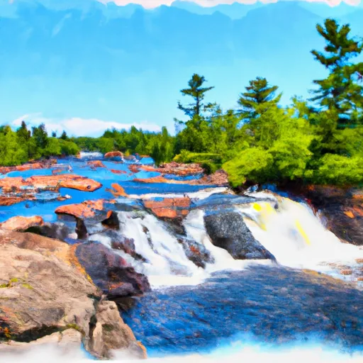
One of the most notable rapids on this run is Ambajejus Falls, which is a steep, 25-foot drop that requires precise navigation. Other rapids to watch out for include The Fingers, which is a series of narrow channels that require technical maneuvering, and the Cribworks, which is a rocky area that can create challenging hydraulics.
There are regulations in place for this area, and all boaters are required to obtain a permit from the Maine Bureau of Parks and Lands. Additionally, visitors should be aware of the Leave No Trace principles and carry out all trash and waste. The area is also a protected wilderness, so camping and fires are only permitted in designated areas.
Overall, the Ambajejus Falls to the End of North and South Twin Lakes river run is a thrilling adventure for experienced paddlers. It is important to check water levels and follow all regulations to ensure a safe and enjoyable trip.
Plan your run down to the hour
Same weather feed Snoflo's iOS app uses -- updated continuously from NOAA / yr.no. Watch the precipitation column on the meteogram; rain ahead of a run typically lifts flows 12-48 hours later depending on the basin.
Next 5 days, hour by hour
Temperature line with weather symbols on top, snow + rain accumulation as columns, humidity as a dotted line.
5-day forecast table
Every 3 hours, broken out across temperature, snow, rain, humidity, and wind. Each cell is colour-coded relative to the column min/max.
| Time | Condition | Temp (°F) | Snow (in) | Rain (in) | Humidity (%) | Wind (mps) | Wind dir |
|---|---|---|---|---|---|---|---|
| Loading detailed forecast… | |||||||
15-day temperature & precipitation
Daily temperatures, snow, and rain projected over the next two weeks -- the upstream story that drives next week's flows.
Regional streamflow levels
USGS streamgauges around Ambajejus Falls To The End Of North And South Twin Lakes -- useful for spotting upstream pulses and gauging which tributary is contributing what.
| Streamgauge | Discharge | View |
|---|---|---|
| East Branch Penobscot River At Grindstone | 577 cfs | → |
| Seboeis River Near Shin Pond | 31 cfs | → |
| Piscataquis River At Medford | 244 cfs | → |
| Mattawamkeag River Near Mattawamkeag | 275 cfs | → |
| Penobscot River At West Enfield | 4,480 cfs | → |
| Piscataquis River Near Dover-Foxcroft | 43 cfs | → |
Plan a longer trip
The closest boat launches, other paddle runs, and campgrounds so a day on the water can grow into a full weekend.
Boat launches
- Golden Road Maine
- Fredericka's Way Maine
- Debsconeag Deadwater
- Landing Road Penobscot County
- Trail Penobscot County
- South Twin Lake
Whitewater safety
- Check the flow before you run
- Use the linked-gauge card and Regional Flow panel above. Class ratings change with flow -- a Class III at low water can become Class IV+ at high water.
- Know your skill ceiling
- Pick runs comfortably below your ceiling. Cold-water and big-water runs raise the consequences of any mistake.
- Wear the right gear
- Helmet, PFD, drysuit / wetsuit when water is below 60°F. Throw bag, knife, and whistle on your person, not in the boat.
- Scout, set safety, and run with a team
- Scout new rapids on foot, set safety with throw bags above the consequence pool, and run with at least one other competent paddler.
- Respect the river
- Strainers, undercuts, low-head dams, and wood can kill at any class rating. When in doubt, portage.
Set push alerts in the Snoflo app
Save Ambajejus Falls To The End Of North And South Twin Lakes as a favorite, set a discharge threshold (e.g. "alert me when flow hits 600 cfs"), and the iOS app pushes the moment the linked gauge crosses.
About Ambajejus Falls To The End Of North And South Twin Lakes
What's the optimal flow for Ambajejus Falls To The End Of North And South Twin Lakes?
The optimal flow depends on the section and the craft. Check the Run Details panel for the linked gauge and current status.
How fresh is the cfs reading on this page?
The linked USGS streamgauge reports continuously (every 15 minutes); Snoflo refreshes throughout the day. Hover the streamflow sparkline to read individual datapoints.
What's the whitewater class?
See the Run Details panel for the class rating Snoflo tracks for this run. Class ratings change with flow -- a Class III at low water can become Class IV in high water.
Where do I put in / take out?
Tap Directions in the hero above to open driving directions to the put-in. For shuttle planning, check the Nearby Boat Launches panel and the river run operator's site.
Can I get alerts when flows hit the optimal range?
Yes -- alerts are managed in the Snoflo iOS app. Favorite this run, set a discharge threshold, and you'll get a push the moment the gauge crosses.
Other runs near here
Snoflo-tracked paddle runs within driving distance of Ambajejus Falls To The End Of North And South Twin Lakes.