Summary
The ideal streamflow range for this run is between 350-700 cfs, depending on the skill level of the paddlers. The river is rated as a Class I-II, with occasional Class III rapids in certain sections. The total distance of the run is approximately 28 miles, with varying scenery and obstacles along the way.
Some of the notable rapids and obstacles on the Whitewater River Run include the "Narrows," a narrow passage with fast-moving water and several rocks, and the "S-Bend," a sharp turn with a strong current. Paddlers should also be aware of fallen trees and other debris that may obstruct the river in certain areas.
It is important to note that there are specific regulations in place for this area. The use of motorized watercraft is prohibited on the Whitewater River, and all paddlers must wear a personal flotation device (PFD) at all times. Additionally, camping is only allowed in designated areas along the river. Paddlers should be respectful of the natural environment and follow Leave No Trace principles.
°F
°F
mph
Wind
%
Humidity
15-Day Weather Outlook
River Run Details
| Last Updated | 2025-11-21 |
| River Levels | 287 cfs (3.43 ft) |
| Percent of Normal | 85% |
| Status | |
| Class Level | i-ii |
| Elevation | ft |
| Run Length | 11.0 Mi |
| Streamflow Discharge | cfs |
| Gauge Height | ft |
| Reporting Streamgage | USGS 05200510 |
5-Day Hourly Forecast Detail
Nearby Streamflow Levels
 Mississippi River Near Bemidji
|
169cfs |
 Mississippi River At Grand Rapids
|
1030cfs |
 Straight River Near Park Rapids
|
46cfs |
 Red Lake River Near Red Lake
|
385cfs |
 Prairie River Near Taconite
|
63cfs |
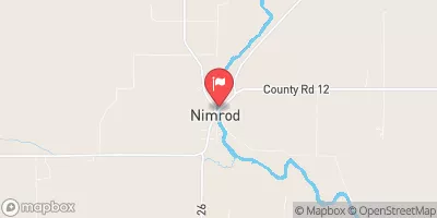 Crow Wing River At Nimrod
|
279cfs |
Area Campgrounds
| Location | Reservations | Toilets |
|---|---|---|
 Knutson Dam Campground
|
||
 Knutson Dam
|
||
 Bimijiwan (formerly Knutson Dam) recreation area
|
||
 Camp Cassaway
|
||
 Wanaki
|
||
 Wanaki Campground Loop
|


 Power Dam Road Northeast Beltrami County
 Cass Lake
To Lake Winnibigoshish
 The Otter Tail Powerplant
To Allen'S Bay