The Discharge Of The Flood Diversion Channel To Riverton River Run
Community Reviews
Been here? Share the conditions.
Reviews, ratings & photos are added in the free Snoflo iOS app — rate a spot, tag the conditions, and your visit is verified by location. Add or manage your reviews from the app.
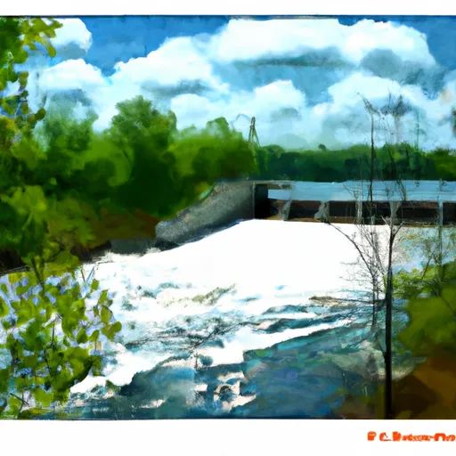
The Discharge Of The Flood Diversion Channel To Riverton
The segment mileage for the Whitewater River Run is 8.5 miles, starting at the diversion dam in St. Charles and ending at Riverton. Along the way, paddlers will encounter several rapids and obstacles, including the "Powerline Drop," "Tub Grinder," and "Lunch Counter." These rapids range in difficulty from Class II to Class III, depending on the water level.
To ensure the safety of paddlers and protect the natural environment, there are several regulations in place for the Whitewater River Run. Paddlers are required to wear personal flotation devices (PFDs) at all times, and alcohol is prohibited on the river. Additionally, there are designated access points for put-ins and take-outs, and paddlers are not allowed to disturb the riverbed or surrounding vegetation.
Overall, the Whitewater River Run is a challenging and rewarding whitewater experience for intermediate paddlers. It is important to consult multiple sources to verify current water levels and any updates to regulations or access points.
Plan your run down to the hour
Same weather feed Snoflo's iOS app uses -- updated continuously from NOAA / yr.no. Watch the precipitation column on the meteogram; rain ahead of a run typically lifts flows 12-48 hours later depending on the basin.
Next 5 days, hour by hour
Temperature line with weather symbols on top, snow + rain accumulation as columns, humidity as a dotted line.
5-day forecast table
Every 3 hours, broken out across temperature, snow, rain, humidity, and wind. Each cell is colour-coded relative to the column min/max.
| Time | Condition | Temp (°F) | Snow (in) | Rain (in) | Humidity (%) | Wind (mps) | Wind dir |
|---|---|---|---|---|---|---|---|
| Loading detailed forecast… | |||||||
15-day temperature & precipitation
Daily temperatures, snow, and rain projected over the next two weeks -- the upstream story that drives next week's flows.
Regional streamflow levels
USGS streamgauges around The Discharge Of The Flood Diversion Channel To Riverton -- useful for spotting upstream pulses and gauging which tributary is contributing what.
| Streamgauge | Discharge | View |
|---|---|---|
| Mississippi River At Aitkin | 496 cfs | → |
| Mississippi River At Brainerd | 530 cfs | → |
| Crow Wing River Near Pillager | 453 cfs | → |
| Mississippi River At Grand Rapids | 192 cfs | → |
| Crow Wing River At Nimrod | 134 cfs | → |
| Kettle River Below Sandstone | 100 cfs | → |
Plan a longer trip
The closest boat launches, other paddle runs, and campgrounds so a day on the water can grow into a full weekend.
Boat launches
Other river runs
- The Boundary Between Logan And Workman Townships In Aitkin County To The Dam Entrance Of The Flood Diversion Channel
- The 25-Acre Island Just South Of Brainerd To Roscoe Island
- Carlton County State Aid Highway #12 Bridge To The Site Of Old Sandstone Hydroelectric Dam
- The Confluence Of The Prairie River To The Boundary Of Logan And Workman Townships
- The Site Of Old Sandstone Hydroelectric Dam To The Confluence With St. Croix River
Campgrounds
- Aitkin County Campground
- Cuyuna Mountain Bike Campground
- Crosby Memorial Park
- Crosby Memorial City Park Campground
- Cuyuna Country Sra - Portsmouth Cg
- True North Basecamp
Fishing spots
Parks
Whitewater safety
- Check the flow before you run
- Use the linked-gauge card and Regional Flow panel above. Class ratings change with flow -- a Class III at low water can become Class IV+ at high water.
- Know your skill ceiling
- Pick runs comfortably below your ceiling. Cold-water and big-water runs raise the consequences of any mistake.
- Wear the right gear
- Helmet, PFD, drysuit / wetsuit when water is below 60°F. Throw bag, knife, and whistle on your person, not in the boat.
- Scout, set safety, and run with a team
- Scout new rapids on foot, set safety with throw bags above the consequence pool, and run with at least one other competent paddler.
- Respect the river
- Strainers, undercuts, low-head dams, and wood can kill at any class rating. When in doubt, portage.
Set push alerts in the Snoflo app
Save The Discharge Of The Flood Diversion Channel To Riverton as a favorite, set a discharge threshold (e.g. "alert me when flow hits 600 cfs"), and the iOS app pushes the moment the linked gauge crosses.
About The Discharge Of The Flood Diversion Channel To Riverton
What's the optimal flow for The Discharge Of The Flood Diversion Channel To Riverton ?
The optimal flow depends on the section and the craft. Check the Run Details panel for the linked gauge and current status.
How fresh is the cfs reading on this page?
The linked USGS streamgauge reports continuously (every 15 minutes); Snoflo refreshes throughout the day. Hover the streamflow sparkline to read individual datapoints.
What's the whitewater class?
See the Run Details panel for the class rating Snoflo tracks for this run. Class ratings change with flow -- a Class III at low water can become Class IV in high water.
Where do I put in / take out?
Tap Directions in the hero above to open driving directions to the put-in. For shuttle planning, check the Nearby Boat Launches panel and the river run operator's site.
Can I get alerts when flows hit the optimal range?
Yes -- alerts are managed in the Snoflo iOS app. Favorite this run, set a discharge threshold, and you'll get a push the moment the gauge crosses.
Other runs near here
Snoflo-tracked paddle runs within driving distance of The Discharge Of The Flood Diversion Channel To Riverton .