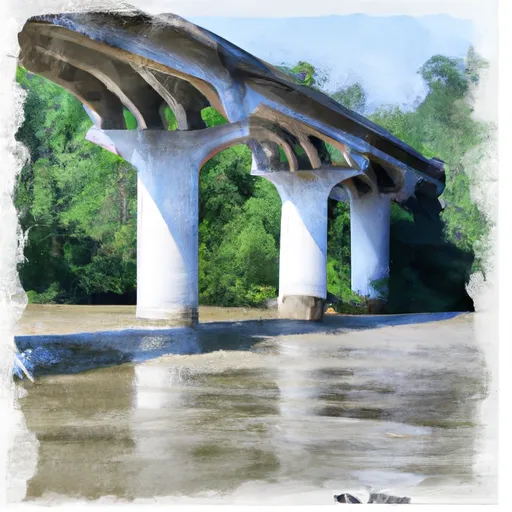
The Jackson County Route 614 Bridge To Ends Approximately 2 River Miles From The Southern Terminus Of The Study Area River Run
Community Reviews
Been here? Share the conditions.
Reviews, ratings & photos are added in the free Snoflo iOS app — rate a spot, tag the conditions, and your visit is verified by location. Add or manage your reviews from the app.
The Jackson County Route 614 Bridge To Ends Approximately 2 River Miles From The Southern Terminus Of The Study Area
Specific river rapids and obstacles include "The Wall," a large rock formation that creates a significant drop in the river, and "The Narrows," a narrow section of river with multiple boulder obstacles. It is important for paddlers to be aware of these obstacles and have proper skills and equipment to navigate them safely.
Specific regulations for the area include a requirement for all paddlers to wear a personal flotation device and for each boat to have a whistle and a throwable flotation device. Additionally, alcohol is prohibited on the river and all litter must be carried out. It is important for visitors to respect these regulations in order to preserve the natural beauty and safety of the area.
Plan your run down to the hour
Same weather feed Snoflo's iOS app uses -- updated continuously from NOAA / yr.no. Watch the precipitation column on the meteogram; rain ahead of a run typically lifts flows 12-48 hours later depending on the basin.
Next 5 days, hour by hour
Temperature line with weather symbols on top, snow + rain accumulation as columns, humidity as a dotted line.
5-day forecast table
Every 3 hours, broken out across temperature, snow, rain, humidity, and wind. Each cell is colour-coded relative to the column min/max.
| Time | Condition | Temp (°F) | Snow (in) | Rain (in) | Humidity (%) | Wind (mps) | Wind dir |
|---|---|---|---|---|---|---|---|
| Loading detailed forecast… | |||||||
15-day temperature & precipitation
Daily temperatures, snow, and rain projected over the next two weeks -- the upstream story that drives next week's flows.
Regional streamflow levels
USGS streamgauges around The Jackson County Route 614 Bridge To Ends Approximately 2 River Miles From The Southern Terminus Of The Study Area -- useful for spotting upstream pulses and gauging which tributary is contributing what.
| Streamgauge | Discharge | View |
|---|---|---|
| Escatawpa River Near Agricola Ms | 386 cfs | → |
| Big Creek At County Rd 63 Near Wilmer | 22 cfs | → |
| Crooked Creek Near Fairview | 13 cfs | → |
| Hamilton Creek At Snow Road Near Semmes | 15 cfs | → |
| Pascagoula River At Graham Ferry | 4,210 cfs | → |
| Chickasaw Creek Near Kushla Al | 86 cfs | → |
Plan a longer trip
The closest boat launches, other paddle runs, and campgrounds so a day on the water can grow into a full weekend.
Boat launches
- Howells Ferry Road 11999, Mobile County
- Dog River
- Pascagoula River
- Goff Dead River
- Lower Pascagoula Wildlife Management Area
- Cane Lake
Other river runs
- Begins Approximately 1 River Mile Upstream From The U.S. Highway 98 Bridge To The Jackson County Route 614 Bridge
- The Confluence With Scarsborough Creek To The Confluence With The Escatawpa River
- Begins Approximately 2 River Miles Downstream From The Yellowhouse Branch Confluence With The Escatawpa River Near The Town Of Deer Park, Alabama To Ends Approximately 1 River Mile Upstream From The U.S. Highway 98 Bridge
- Confluence With Yellow River To County Road In Sec 7
- Southern Nf Boundary To Northern Nf Boundary
Whitewater safety
- Check the flow before you run
- Use the linked-gauge card and Regional Flow panel above. Class ratings change with flow -- a Class III at low water can become Class IV+ at high water.
- Know your skill ceiling
- Pick runs comfortably below your ceiling. Cold-water and big-water runs raise the consequences of any mistake.
- Wear the right gear
- Helmet, PFD, drysuit / wetsuit when water is below 60°F. Throw bag, knife, and whistle on your person, not in the boat.
- Scout, set safety, and run with a team
- Scout new rapids on foot, set safety with throw bags above the consequence pool, and run with at least one other competent paddler.
- Respect the river
- Strainers, undercuts, low-head dams, and wood can kill at any class rating. When in doubt, portage.
Set push alerts in the Snoflo app
Save The Jackson County Route 614 Bridge To Ends Approximately 2 River Miles From The Southern Terminus Of The Study Area as a favorite, set a discharge threshold (e.g. "alert me when flow hits 600 cfs"), and the iOS app pushes the moment the linked gauge crosses.
About The Jackson County Route 614 Bridge To Ends Approximately 2 River Miles From The Southern Terminus Of The Study Area
What's the optimal flow for The Jackson County Route 614 Bridge To Ends Approximately 2 River Miles From The Southern Terminus Of The Study Area ?
The optimal flow depends on the section and the craft. Check the Run Details panel for the linked gauge and current status.
How fresh is the cfs reading on this page?
The linked USGS streamgauge reports continuously (every 15 minutes); Snoflo refreshes throughout the day. Hover the streamflow sparkline to read individual datapoints.
What's the whitewater class?
See the Run Details panel for the class rating Snoflo tracks for this run. Class ratings change with flow -- a Class III at low water can become Class IV in high water.
Where do I put in / take out?
Tap Directions in the hero above to open driving directions to the put-in. For shuttle planning, check the Nearby Boat Launches panel and the river run operator's site.
Can I get alerts when flows hit the optimal range?
Yes -- alerts are managed in the Snoflo iOS app. Favorite this run, set a discharge threshold, and you'll get a push the moment the gauge crosses.
Other runs near here
Snoflo-tracked paddle runs within driving distance of The Jackson County Route 614 Bridge To Ends Approximately 2 River Miles From The Southern Terminus Of The Study Area .