Willow Creek, Sec. 32, T24n, R29w To Noxon Reservoir, Sec. 14, T24n, R31w River Run
Community Reviews
Been here? Share the conditions.
Reviews, ratings & photos are added in the free Snoflo iOS app — rate a spot, tag the conditions, and your visit is verified by location. Add or manage your reviews from the app.
Willow Creek, Sec. 32, T24n, R29w To Noxon Reservoir, Sec. 14, T24n, R31w
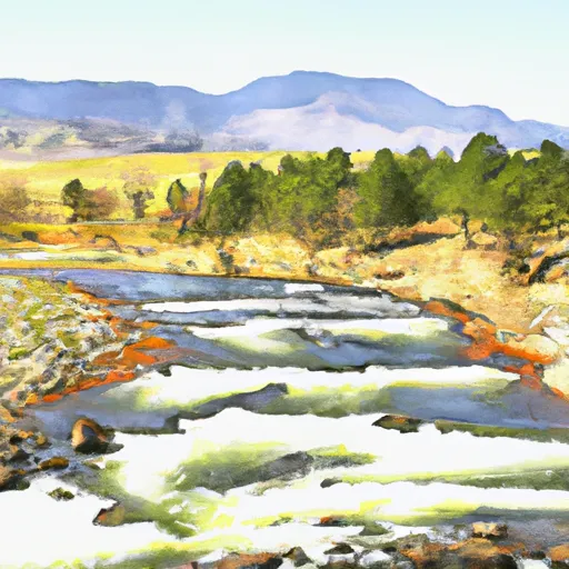
The run starts at Willow Creek in Section 32, T24N, R29W and ends at Noxon Reservoir in Section 14, T24N, R31W. The river is characterized by rapids, including Lightning Bolt, Fang, and the Devil’s Toenail. These rapids are challenging and require experienced paddlers to navigate safely.
The Montana Department of Fish, Wildlife, and Parks manages the Noxon Rapids Reservoir. The reservoir has specific regulations for anglers and boaters, including mandatory boat inspections for aquatic invasive species. The Noxon Reservoir also has designated areas for camping and boating.
In conclusion, the Willow Creek to Noxon Reservoir Whitewater River Run is a thrilling experience suitable for intermediate and experienced paddlers. It is essential to check the streamflow range before embarking on the trip and abide by the specific regulations set out by the Montana Department of Fish, Wildlife, and Parks.
Plan your run down to the hour
Same weather feed Snoflo's iOS app uses -- updated continuously from NOAA / yr.no. Watch the precipitation column on the meteogram; rain ahead of a run typically lifts flows 12-48 hours later depending on the basin.
Next 5 days, hour by hour
Temperature line with weather symbols on top, snow + rain accumulation as columns, humidity as a dotted line.
5-day forecast table
Every 3 hours, broken out across temperature, snow, rain, humidity, and wind. Each cell is colour-coded relative to the column min/max.
| Time | Condition | Temp (°F) | Snow (in) | Rain (in) | Humidity (%) | Wind (mps) | Wind dir |
|---|---|---|---|---|---|---|---|
| Loading detailed forecast… | |||||||
15-day temperature & precipitation
Daily temperatures, snow, and rain projected over the next two weeks -- the upstream story that drives next week's flows.
Regional streamflow levels
USGS streamgauges around Willow Creek, Sec. 32, T24n, R29w To Noxon Reservoir, Sec. 14, T24n, R31w -- useful for spotting upstream pulses and gauging which tributary is contributing what.
| Streamgauge | Discharge | View |
|---|---|---|
| Prospect Creek At Thompson Falls Mt | 74 cfs | → |
| Thompson River Near Thompson Falls Mt | 209 cfs | → |
| Nf Coeur D Alene R Ab Shoshone Ck Nr Prichard Id | 83 cfs | → |
| Ninemile Creek Ab Mouth At Wallace | 5 cfs | → |
| Clark Fork River Below Cabinet Gorge Dam Id | 4,420 cfs | → |
| Canyon Creek Ab Mouth At Wallace | 17 cfs | → |
Plan a longer trip
The closest boat launches, other paddle runs, and campgrounds so a day on the water can grow into a full weekend.
Boat launches
- Trout Creek
- North Shore Road Trout Creek;Trout Creek Post Office
- Usfs Road 2229 Sanders County
- Dam Site
- Flatiron Ridge
- Thompson Falls State Recreation Area
Other river runs
- Vermilion River
- Boundary Proposed Addition Cabinet Mtns Wilderness, Sec. To Cabinet Gorge Reservoir
- East Fork Bull River, Headwaters, Sec. 13, T27n, R32w To Cabinet Mountains Wilderness Boundary, Sec. 3, T27n, R32w
- Cabinet Mtns Wilderness Boundary, Sec. 3, T27n, R32w To Bull River, Sec. 12, T27n, R33w
- Middle Fork Bull River, Sec. 9, T28n, R33w To Proposed Addition To Cabinet Mtns Wilderness, Sec. 12, T28n, R33w
Whitewater safety
- Check the flow before you run
- Use the linked-gauge card and Regional Flow panel above. Class ratings change with flow -- a Class III at low water can become Class IV+ at high water.
- Know your skill ceiling
- Pick runs comfortably below your ceiling. Cold-water and big-water runs raise the consequences of any mistake.
- Wear the right gear
- Helmet, PFD, drysuit / wetsuit when water is below 60°F. Throw bag, knife, and whistle on your person, not in the boat.
- Scout, set safety, and run with a team
- Scout new rapids on foot, set safety with throw bags above the consequence pool, and run with at least one other competent paddler.
- Respect the river
- Strainers, undercuts, low-head dams, and wood can kill at any class rating. When in doubt, portage.
Set push alerts in the Snoflo app
Save Willow Creek, Sec. 32, T24n, R29w To Noxon Reservoir, Sec. 14, T24n, R31w as a favorite, set a discharge threshold (e.g. "alert me when flow hits 600 cfs"), and the iOS app pushes the moment the linked gauge crosses.
About Willow Creek, Sec. 32, T24n, R29w To Noxon Reservoir, Sec. 14, T24n, R31w
What's the optimal flow for Willow Creek, Sec. 32, T24n, R29w To Noxon Reservoir, Sec. 14, T24n, R31w?
The optimal flow depends on the section and the craft. Check the Run Details panel for the linked gauge and current status.
How fresh is the cfs reading on this page?
The linked USGS streamgauge reports continuously (every 15 minutes); Snoflo refreshes throughout the day. Hover the streamflow sparkline to read individual datapoints.
What's the whitewater class?
See the Run Details panel for the class rating Snoflo tracks for this run. Class ratings change with flow -- a Class III at low water can become Class IV in high water.
Where do I put in / take out?
Tap Directions in the hero above to open driving directions to the put-in. For shuttle planning, check the Nearby Boat Launches panel and the river run operator's site.
Can I get alerts when flows hit the optimal range?
Yes -- alerts are managed in the Snoflo iOS app. Favorite this run, set a discharge threshold, and you'll get a push the moment the gauge crosses.
Other runs near here
Snoflo-tracked paddle runs within driving distance of Willow Creek, Sec. 32, T24n, R29w To Noxon Reservoir, Sec. 14, T24n, R31w.