Arch Coulee Junction, Sec. 32, T13n, R11e To Forest Boundary, Sec. 35, T13n, R11e River Run
Community Reviews
Been here? Share the conditions.
Reviews, ratings & photos are added in the free Snoflo iOS app — rate a spot, tag the conditions, and your visit is verified by location. Add or manage your reviews from the app.
Arch Coulee Junction, Sec. 32, T13n, R11e To Forest Boundary, Sec. 35, T13n, R11e
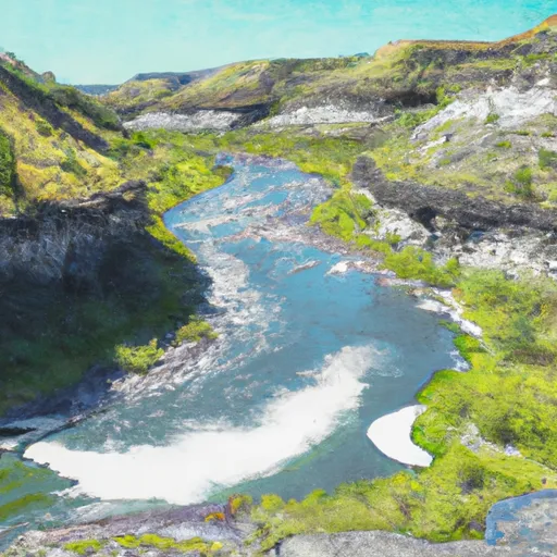
The run covers a distance of approximately 9.5 miles, starting at Arch Coulee Junction in section 32, T13N, R11E and ending at the forest boundary in section 35, T13N, R11E. Along the way, paddlers will encounter numerous rapids and obstacles, including Class II rapids like Little Redfish, Big Redfish, and Jerry's Hole, as well as the Class III rapids of The Narrows, and Grizzly Rapid.
To ensure the safety and preservation of the area, there are specific regulations that paddlers must follow. These include obtaining a permit from the Bureau of Land Management before entering the area, adhering to Leave No Trace principles, and respecting private property. Additionally, motorized boats are not allowed on this section of the river.
Overall, the Whitewater River Run offers a thrilling and challenging experience for whitewater enthusiasts, with its ideal streamflow range, Class II-III rating, and variety of rapids and obstacles. It is important to follow regulations and safety guidelines to ensure a safe and enjoyable experience for all.
Plan your run down to the hour
Same weather feed Snoflo's iOS app uses -- updated continuously from NOAA / yr.no. Watch the precipitation column on the meteogram; rain ahead of a run typically lifts flows 12-48 hours later depending on the basin.
Next 5 days, hour by hour
Temperature line with weather symbols on top, snow + rain accumulation as columns, humidity as a dotted line.
5-day forecast table
Every 3 hours, broken out across temperature, snow, rain, humidity, and wind. Each cell is colour-coded relative to the column min/max.
| Time | Condition | Temp (°F) | Snow (in) | Rain (in) | Humidity (%) | Wind (mps) | Wind dir |
|---|---|---|---|---|---|---|---|
| Loading detailed forecast… | |||||||
15-day temperature & precipitation
Daily temperatures, snow, and rain projected over the next two weeks -- the upstream story that drives next week's flows.
Regional streamflow levels
USGS streamgauges around Arch Coulee Junction, Sec. 32, T13n, R11e To Forest Boundary, Sec. 35, T13n, R11e -- useful for spotting upstream pulses and gauging which tributary is contributing what.
| Streamgauge | Discharge | View |
|---|---|---|
| Musselshell River Nr Martinsdale | 34 cfs | → |
| South Fork Musselshell R Ab Martinsdale Mt | 43 cfs | → |
| Musselshell River At Harlowton Mt | 24 cfs | → |
| Belt Creek Near Monarch Mt | 128 cfs | → |
| Smith River Near Ft Logan Mt | 74 cfs | → |
| Smith River Bl Eagle Cr Nr Fort Logan Mt | 113 cfs | → |
Plan a longer trip
The closest boat launches, other paddle runs, and campgrounds so a day on the water can grow into a full weekend.
Other river runs
- Camp Baker To Eden Bridge
- Falls, Sec. 25, T14n, R4e To Smith River, Sec. 25, T14n, R3e
- Tenderfoot Creek, Sec. 30, T14n, R4e To Deep Creek, Sec. 31, T16n, R4e
- Marias River
- Missouri River
Campgrounds
- Judith Station Campground
- Judith Station
- Judith Station Day Use Area
- Judith Guard Station Cabin
- Indian Hill
- Judith River State Wma
Fishing spots
Whitewater safety
- Check the flow before you run
- Use the linked-gauge card and Regional Flow panel above. Class ratings change with flow -- a Class III at low water can become Class IV+ at high water.
- Know your skill ceiling
- Pick runs comfortably below your ceiling. Cold-water and big-water runs raise the consequences of any mistake.
- Wear the right gear
- Helmet, PFD, drysuit / wetsuit when water is below 60°F. Throw bag, knife, and whistle on your person, not in the boat.
- Scout, set safety, and run with a team
- Scout new rapids on foot, set safety with throw bags above the consequence pool, and run with at least one other competent paddler.
- Respect the river
- Strainers, undercuts, low-head dams, and wood can kill at any class rating. When in doubt, portage.
Set push alerts in the Snoflo app
Save Arch Coulee Junction, Sec. 32, T13n, R11e To Forest Boundary, Sec. 35, T13n, R11e as a favorite, set a discharge threshold (e.g. "alert me when flow hits 600 cfs"), and the iOS app pushes the moment the linked gauge crosses.
About Arch Coulee Junction, Sec. 32, T13n, R11e To Forest Boundary, Sec. 35, T13n, R11e
What's the optimal flow for Arch Coulee Junction, Sec. 32, T13n, R11e To Forest Boundary, Sec. 35, T13n, R11e?
The optimal flow depends on the section and the craft. Check the Run Details panel for the linked gauge and current status.
How fresh is the cfs reading on this page?
The linked USGS streamgauge reports continuously (every 15 minutes); Snoflo refreshes throughout the day. Hover the streamflow sparkline to read individual datapoints.
What's the whitewater class?
See the Run Details panel for the class rating Snoflo tracks for this run. Class ratings change with flow -- a Class III at low water can become Class IV in high water.
Where do I put in / take out?
Tap Directions in the hero above to open driving directions to the put-in. For shuttle planning, check the Nearby Boat Launches panel and the river run operator's site.
Can I get alerts when flows hit the optimal range?
Yes -- alerts are managed in the Snoflo iOS app. Favorite this run, set a discharge threshold, and you'll get a push the moment the gauge crosses.
Other runs near here
Snoflo-tracked paddle runs within driving distance of Arch Coulee Junction, Sec. 32, T13n, R11e To Forest Boundary, Sec. 35, T13n, R11e.