Sec. 29, T.8s, R.13w To All Upstream Waters River Run
Community Reviews
Been here? Share the conditions.
Reviews, ratings & photos are added in the free Snoflo iOS app — rate a spot, tag the conditions, and your visit is verified by location. Add or manage your reviews from the app.
Sec. 29, T.8s, R.13w To All Upstream Waters
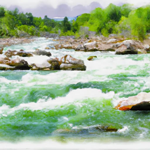
The whitewater river run is classified as a class III to IV rapid, which means it contains moderate to difficult rapids and obstacles. The rapids in this section are characterized by steep drops, tight chutes, and large waves. One of the most challenging rapids in this section is the "Fang" rapid, which features a large, menacing rock in the middle of the river.
To ensure a safe and enjoyable experience, it is recommended that kayakers and rafters have previous whitewater experience before attempting this section. Additionally, personal flotation devices (PFDs) are required by law for all participants. It is also important to be aware of any special regulations in the area, such as restricted access during certain times of the year or designated camping areas.
Overall, the whitewater river run from Sec. 29, T.8S, R.13W to all upstream waters in Montana offers a challenging and exhilarating experience for those seeking an adventure on the water. It is important to always prioritize safety and follow all regulations to ensure a successful trip.
Plan your run down to the hour
Same weather feed Snoflo's iOS app uses -- updated continuously from NOAA / yr.no. Watch the precipitation column on the meteogram; rain ahead of a run typically lifts flows 12-48 hours later depending on the basin.
Next 5 days, hour by hour
Temperature line with weather symbols on top, snow + rain accumulation as columns, humidity as a dotted line.
5-day forecast table
Every 3 hours, broken out across temperature, snow, rain, humidity, and wind. Each cell is colour-coded relative to the column min/max.
| Time | Condition | Temp (°F) | Snow (in) | Rain (in) | Humidity (%) | Wind (mps) | Wind dir |
|---|---|---|---|---|---|---|---|
| Loading detailed forecast… | |||||||
15-day temperature & precipitation
Daily temperatures, snow, and rain projected over the next two weeks -- the upstream story that drives next week's flows.
Regional streamflow levels
USGS streamgauges around Sec. 29, T.8s, R.13w To All Upstream Waters -- useful for spotting upstream pulses and gauging which tributary is contributing what.
| Streamgauge | Discharge | View |
|---|---|---|
| Big Hole River Near Jackson Mt | 25 cfs | → |
| Beaverhead River At Barretts Mt | 547 cfs | → |
| Lemhi River Nr Lemhi Id | 144 cfs | → |
| Lemhi River Below L5 Diversion Near Salmon | 76 cfs | → |
| Beaverhead River At Dillon Mt | 126 cfs | → |
| Salmon River At Salmon Id | 1,700 cfs | → |
Plan a longer trip
The closest boat launches, other paddle runs, and campgrounds so a day on the water can grow into a full weekend.
Whitewater safety
- Check the flow before you run
- Use the linked-gauge card and Regional Flow panel above. Class ratings change with flow -- a Class III at low water can become Class IV+ at high water.
- Know your skill ceiling
- Pick runs comfortably below your ceiling. Cold-water and big-water runs raise the consequences of any mistake.
- Wear the right gear
- Helmet, PFD, drysuit / wetsuit when water is below 60°F. Throw bag, knife, and whistle on your person, not in the boat.
- Scout, set safety, and run with a team
- Scout new rapids on foot, set safety with throw bags above the consequence pool, and run with at least one other competent paddler.
- Respect the river
- Strainers, undercuts, low-head dams, and wood can kill at any class rating. When in doubt, portage.
Set push alerts in the Snoflo app
Save Sec. 29, T.8s, R.13w To All Upstream Waters as a favorite, set a discharge threshold (e.g. "alert me when flow hits 600 cfs"), and the iOS app pushes the moment the linked gauge crosses.
About Sec. 29, T.8s, R.13w To All Upstream Waters
What's the optimal flow for Sec. 29, T.8s, R.13w To All Upstream Waters?
The optimal flow depends on the section and the craft. Check the Run Details panel for the linked gauge and current status.
How fresh is the cfs reading on this page?
The linked USGS streamgauge reports continuously (every 15 minutes); Snoflo refreshes throughout the day. Hover the streamflow sparkline to read individual datapoints.
What's the whitewater class?
See the Run Details panel for the class rating Snoflo tracks for this run. Class ratings change with flow -- a Class III at low water can become Class IV in high water.
Where do I put in / take out?
Tap Directions in the hero above to open driving directions to the put-in. For shuttle planning, check the Nearby Boat Launches panel and the river run operator's site.
Can I get alerts when flows hit the optimal range?
Yes -- alerts are managed in the Snoflo iOS app. Favorite this run, set a discharge threshold, and you'll get a push the moment the gauge crosses.
Other runs near here
Snoflo-tracked paddle runs within driving distance of Sec. 29, T.8s, R.13w To All Upstream Waters.