Sec 15, T2s, R10w To Lion Cr, Sec. 4, T3s, R11w River Run
Community Reviews
Been here? Share the conditions.
Reviews, ratings & photos are added in the free Snoflo iOS app — rate a spot, tag the conditions, and your visit is verified by location. Add or manage your reviews from the app.
Sec 15, T2s, R10w To Lion Cr, Sec. 4, T3s, R11w
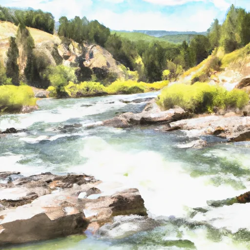
Specific river rapids and obstacles on this run include Devil's Kitchen, which is a Class IV rapid that requires technical maneuvering around large boulders, and Fangs, a Class III rapid that features a series of narrow chutes and drops. Additionally, the run includes several smaller rapids and riffles that require precise navigation.
Specific regulations for the area include mandatory life jackets for all boaters and a ban on alcohol consumption while on the river. Additionally, the river is closed to floating during periods of high water, and all boaters must carry a fire extinguisher and a whistle.
Sources for this information include Montana River Action and the Montana Department of Fish, Wildlife, and Parks. It is important to verify the accuracy of information related to river conditions and regulations before undertaking any river activity.
Plan your run down to the hour
Same weather feed Snoflo's iOS app uses -- updated continuously from NOAA / yr.no. Watch the precipitation column on the meteogram; rain ahead of a run typically lifts flows 12-48 hours later depending on the basin.
Next 5 days, hour by hour
Temperature line with weather symbols on top, snow + rain accumulation as columns, humidity as a dotted line.
5-day forecast table
Every 3 hours, broken out across temperature, snow, rain, humidity, and wind. Each cell is colour-coded relative to the column min/max.
| Time | Condition | Temp (°F) | Snow (in) | Rain (in) | Humidity (%) | Wind (mps) | Wind dir |
|---|---|---|---|---|---|---|---|
| Loading detailed forecast… | |||||||
15-day temperature & precipitation
Daily temperatures, snow, and rain projected over the next two weeks -- the upstream story that drives next week's flows.
Regional streamflow levels
USGS streamgauges around Sec 15, T2s, R10w To Lion Cr, Sec. 4, T3s, R11w -- useful for spotting upstream pulses and gauging which tributary is contributing what.
| Streamgauge | Discharge | View |
|---|---|---|
| Big Hole River At Maiden Rock Nr Divide Mt | 684 cfs | → |
| Big Hole River Near Melrose Mt | 744 cfs | → |
| Big Hole River Near Wise River Mt | 112 cfs | → |
| Big Hole River Near Glen Mt | 655 cfs | → |
| Big Hole River Bl Mudd Cr Nr Wisdom Mt | 343 cfs | → |
| Jefferson River Near Twin Bridges Mt | 840 cfs | → |
Plan a longer trip
The closest boat launches, other paddle runs, and campgrounds so a day on the water can grow into a full weekend.
Whitewater safety
- Check the flow before you run
- Use the linked-gauge card and Regional Flow panel above. Class ratings change with flow -- a Class III at low water can become Class IV+ at high water.
- Know your skill ceiling
- Pick runs comfortably below your ceiling. Cold-water and big-water runs raise the consequences of any mistake.
- Wear the right gear
- Helmet, PFD, drysuit / wetsuit when water is below 60°F. Throw bag, knife, and whistle on your person, not in the boat.
- Scout, set safety, and run with a team
- Scout new rapids on foot, set safety with throw bags above the consequence pool, and run with at least one other competent paddler.
- Respect the river
- Strainers, undercuts, low-head dams, and wood can kill at any class rating. When in doubt, portage.
Set push alerts in the Snoflo app
Save Sec 15, T2s, R10w To Lion Cr, Sec. 4, T3s, R11w as a favorite, set a discharge threshold (e.g. "alert me when flow hits 600 cfs"), and the iOS app pushes the moment the linked gauge crosses.
About Sec 15, T2s, R10w To Lion Cr, Sec. 4, T3s, R11w
What's the optimal flow for Sec 15, T2s, R10w To Lion Cr, Sec. 4, T3s, R11w?
The optimal flow depends on the section and the craft. Check the Run Details panel for the linked gauge and current status.
How fresh is the cfs reading on this page?
The linked USGS streamgauge reports continuously (every 15 minutes); Snoflo refreshes throughout the day. Hover the streamflow sparkline to read individual datapoints.
What's the whitewater class?
See the Run Details panel for the class rating Snoflo tracks for this run. Class ratings change with flow -- a Class III at low water can become Class IV in high water.
Where do I put in / take out?
Tap Directions in the hero above to open driving directions to the put-in. For shuttle planning, check the Nearby Boat Launches panel and the river run operator's site.
Can I get alerts when flows hit the optimal range?
Yes -- alerts are managed in the Snoflo iOS app. Favorite this run, set a discharge threshold, and you'll get a push the moment the gauge crosses.
Other runs near here
Snoflo-tracked paddle runs within driving distance of Sec 15, T2s, R10w To Lion Cr, Sec. 4, T3s, R11w.