Blakley Creek, Sec. 26, T4s, R12e To Miller Creek, Sec 13, T4s, R21e River Run
Community Reviews
Been here? Share the conditions.
Reviews, ratings & photos are added in the free Snoflo iOS app — rate a spot, tag the conditions, and your visit is verified by location. Add or manage your reviews from the app.
Blakley Creek, Sec. 26, T4s, R12e To Miller Creek, Sec 13, T4s, R21e
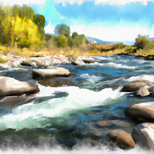
This section of the river is rated as class III-IV, with some difficult rapids and obstacles to navigate. One of the most challenging rapids is called "The Notch," which requires precise maneuvering to avoid a dangerous undercut rock. Other notable obstacles include "Ledge Hole" and "Pinball."
The segment mileage for this run is approximately 12 miles. It begins in Section 26, T4S, R12E, and ends in Section 13, T4S, R21E. The scenery along the way is breathtaking, with towering cliffs, dense forests, and occasional wildlife sightings.
There are specific regulations to be aware of when paddling this section of the river. Boats must have a current Montana Invasive Species Prevention Pass, and all gear must be thoroughly cleaned and dried before entering the water to prevent the spread of invasive species. Additionally, there are restrictions on camping and fires in some areas, so it is important to check with local authorities before setting up camp.
Overall, the Blakley Creek to Miller Creek run is a challenging and rewarding whitewater experience in Montana. Paddlers should be experienced and well-prepared for the rapids and obstacles they will encounter, and should always follow local regulations to protect the environment and ensure the safety of all involved.
Plan your run down to the hour
Same weather feed Snoflo's iOS app uses -- updated continuously from NOAA / yr.no. Watch the precipitation column on the meteogram; rain ahead of a run typically lifts flows 12-48 hours later depending on the basin.
Next 5 days, hour by hour
Temperature line with weather symbols on top, snow + rain accumulation as columns, humidity as a dotted line.
5-day forecast table
Every 3 hours, broken out across temperature, snow, rain, humidity, and wind. Each cell is colour-coded relative to the column min/max.
| Time | Condition | Temp (°F) | Snow (in) | Rain (in) | Humidity (%) | Wind (mps) | Wind dir |
|---|---|---|---|---|---|---|---|
| Loading detailed forecast… | |||||||
15-day temperature & precipitation
Daily temperatures, snow, and rain projected over the next two weeks -- the upstream story that drives next week's flows.
Regional streamflow levels
USGS streamgauges around Blakley Creek, Sec. 26, T4s, R12e To Miller Creek, Sec 13, T4s, R21e -- useful for spotting upstream pulses and gauging which tributary is contributing what.
| Streamgauge | Discharge | View |
|---|---|---|
| Yellowstone River Near Livingston Mt | 3,450 cfs | → |
| Shields River Nr Livingston Mt | 119 cfs | → |
| West Rosebud Creek Near Roscoe Mt | 402 cfs | → |
| Boulder River At Big Timber Mt | 274 cfs | → |
| Soda Butte Cr At Park Bndry At Silver Gate | 54 cfs | → |
| Lamar River Nr Tower Falls Ranger Station Ynp | 423 cfs | → |
Plan a longer trip
The closest boat launches, other paddle runs, and campgrounds so a day on the water can grow into a full weekend.
Other river runs
- Miller Creek, Sec. 13, T4s, R21e To Bramble Creek, Sec. 26, T5s, R12e
- Bible Run
- Bramble Creek, Sec. 26, T5s, R12e To Absaroka-Beartooth Wilderness, Sec. 22, T7s, R12e
- Gallatin Forest Boundary, Sec. 26, T3s, R12e To Blakley Creek, Sec. 26, T3s, R12e
- Absaroka-Beartooth Wilderness Boundary To Headwaters, Sec. 9, T9s, R14e
Campgrounds
Fishing spots
Whitewater safety
- Check the flow before you run
- Use the linked-gauge card and Regional Flow panel above. Class ratings change with flow -- a Class III at low water can become Class IV+ at high water.
- Know your skill ceiling
- Pick runs comfortably below your ceiling. Cold-water and big-water runs raise the consequences of any mistake.
- Wear the right gear
- Helmet, PFD, drysuit / wetsuit when water is below 60°F. Throw bag, knife, and whistle on your person, not in the boat.
- Scout, set safety, and run with a team
- Scout new rapids on foot, set safety with throw bags above the consequence pool, and run with at least one other competent paddler.
- Respect the river
- Strainers, undercuts, low-head dams, and wood can kill at any class rating. When in doubt, portage.
Set push alerts in the Snoflo app
Save Blakley Creek, Sec. 26, T4s, R12e To Miller Creek, Sec 13, T4s, R21e as a favorite, set a discharge threshold (e.g. "alert me when flow hits 600 cfs"), and the iOS app pushes the moment the linked gauge crosses.
About Blakley Creek, Sec. 26, T4s, R12e To Miller Creek, Sec 13, T4s, R21e
What's the optimal flow for Blakley Creek, Sec. 26, T4s, R12e To Miller Creek, Sec 13, T4s, R21e?
The optimal flow depends on the section and the craft. Check the Run Details panel for the linked gauge and current status.
How fresh is the cfs reading on this page?
The linked USGS streamgauge reports continuously (every 15 minutes); Snoflo refreshes throughout the day. Hover the streamflow sparkline to read individual datapoints.
What's the whitewater class?
See the Run Details panel for the class rating Snoflo tracks for this run. Class ratings change with flow -- a Class III at low water can become Class IV in high water.
Where do I put in / take out?
Tap Directions in the hero above to open driving directions to the put-in. For shuttle planning, check the Nearby Boat Launches panel and the river run operator's site.
Can I get alerts when flows hit the optimal range?
Yes -- alerts are managed in the Snoflo iOS app. Favorite this run, set a discharge threshold, and you'll get a push the moment the gauge crosses.
Other runs near here
Snoflo-tracked paddle runs within driving distance of Blakley Creek, Sec. 26, T4s, R12e To Miller Creek, Sec 13, T4s, R21e.