Blackfoot River River Run
Community Reviews
Been here? Share the conditions.
Reviews, ratings & photos are added in the free Snoflo iOS app — rate a spot, tag the conditions, and your visit is verified by location. Add or manage your reviews from the app.
Blackfoot River
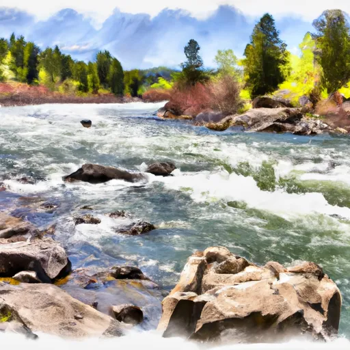
The segment mileage of the Blackfoot River is approximately 60 miles, with the most popular section being the 9-mile stretch from the Johnsrud Fishing Access Site to the Bonner Dam. This section features several rapids and obstacles, including the "Boulder Garden," "Jaws," and "The Fingers."
To protect the natural environment and ensure safety, there are specific regulations in place for the Blackfoot River. Boaters must obtain a permit from the Montana Department of Fish, Wildlife, and Parks before launching their vessel. Additionally, there are restrictions on the use of motorized watercraft and limits on the number of people allowed in each group.
Overall, the Blackfoot River is a challenging and thrilling whitewater run suitable for experienced paddlers. With its beautiful scenery and exciting rapids, it is a must-see destination for any adventurous kayaker or rafting enthusiast.
Plan your run down to the hour
Same weather feed Snoflo's iOS app uses -- updated continuously from NOAA / yr.no. Watch the precipitation column on the meteogram; rain ahead of a run typically lifts flows 12-48 hours later depending on the basin.
Next 5 days, hour by hour
Temperature line with weather symbols on top, snow + rain accumulation as columns, humidity as a dotted line.
5-day forecast table
Every 3 hours, broken out across temperature, snow, rain, humidity, and wind. Each cell is colour-coded relative to the column min/max.
| Time | Condition | Temp (°F) | Snow (in) | Rain (in) | Humidity (%) | Wind (mps) | Wind dir |
|---|---|---|---|---|---|---|---|
| Loading detailed forecast… | |||||||
15-day temperature & precipitation
Daily temperatures, snow, and rain projected over the next two weeks -- the upstream story that drives next week's flows.
Regional streamflow levels
USGS streamgauges around Blackfoot River -- useful for spotting upstream pulses and gauging which tributary is contributing what.
| Streamgauge | Discharge | View |
|---|---|---|
| Blackfoot R Ab Nevada Cr Nr Helmville Mt | 347 cfs | → |
| Nf Blackfoot R Ab Dry Gulch Nr Ovando Mt | 328 cfs | → |
| Nevada Cr Ab Reservoir | 27 cfs | → |
| Flint Creek Near Drummond Mt | 41 cfs | → |
| Clark Fork At Goldcreek Mt | 391 cfs | → |
| Clark Fork Near Drummond Mt | 390 cfs | → |
Plan a longer trip
The closest boat launches, other paddle runs, and campgrounds so a day on the water can grow into a full weekend.
Boat launches
Campgrounds
- Moose Creek Campground (Free)
- Browns Lake Fas
- Harry Morgan Fas
- Big Nelson Campground
- Big Nelson Complex
- Pine Grove Campground
Whitewater safety
- Check the flow before you run
- Use the linked-gauge card and Regional Flow panel above. Class ratings change with flow -- a Class III at low water can become Class IV+ at high water.
- Know your skill ceiling
- Pick runs comfortably below your ceiling. Cold-water and big-water runs raise the consequences of any mistake.
- Wear the right gear
- Helmet, PFD, drysuit / wetsuit when water is below 60°F. Throw bag, knife, and whistle on your person, not in the boat.
- Scout, set safety, and run with a team
- Scout new rapids on foot, set safety with throw bags above the consequence pool, and run with at least one other competent paddler.
- Respect the river
- Strainers, undercuts, low-head dams, and wood can kill at any class rating. When in doubt, portage.
Set push alerts in the Snoflo app
Save Blackfoot River as a favorite, set a discharge threshold (e.g. "alert me when flow hits 600 cfs"), and the iOS app pushes the moment the linked gauge crosses.
About Blackfoot River
What's the optimal flow for Blackfoot River?
The optimal flow depends on the section and the craft. Check the Run Details panel for the linked gauge and current status.
How fresh is the cfs reading on this page?
The linked USGS streamgauge reports continuously (every 15 minutes); Snoflo refreshes throughout the day. Hover the streamflow sparkline to read individual datapoints.
What's the whitewater class?
See the Run Details panel for the class rating Snoflo tracks for this run. Class ratings change with flow -- a Class III at low water can become Class IV in high water.
Where do I put in / take out?
Tap Directions in the hero above to open driving directions to the put-in. For shuttle planning, check the Nearby Boat Launches panel and the river run operator's site.
Can I get alerts when flows hit the optimal range?
Yes -- alerts are managed in the Snoflo iOS app. Favorite this run, set a discharge threshold, and you'll get a push the moment the gauge crosses.
Other runs near here
Snoflo-tracked paddle runs within driving distance of Blackfoot River.