Bad Canyon Creek River Run
Community Reviews
Been here? Share the conditions.
Reviews, ratings & photos are added in the free Snoflo iOS app — rate a spot, tag the conditions, and your visit is verified by location. Add or manage your reviews from the app.
Bad Canyon Creek
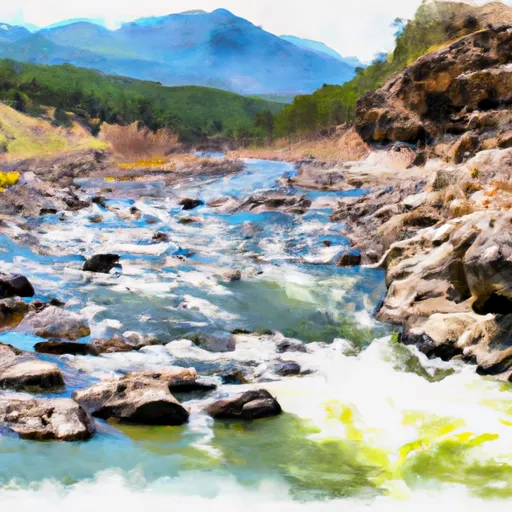
The segment mileage of Bad Canyon Creek is approximately 6 miles. The river rapids and obstacles on this run include steep drops, large boulders, and tight channels. The main rapids on this run are known as the "Boulder Garden" and "The Chute." These rapids require advanced paddling skills and experience to navigate effectively.
In terms of specific regulations, all paddlers must have a Montana state permit to paddle on this river. Additionally, all paddlers must wear a personal flotation device and a helmet at all times while on the river. Paddlers should also be aware of private property along the river and respect the landowners' rights.
Overall, Bad Canyon Creek is a challenging but rewarding whitewater run for experienced paddlers. Its steep drops, tight channels, and large boulders provide a thrilling experience for those with the skills to navigate them. However, paddlers must ensure they are within the ideal streamflow range, have the necessary permits, and adhere to all regulations to ensure a safe and enjoyable trip.
Plan your run down to the hour
Same weather feed Snoflo's iOS app uses -- updated continuously from NOAA / yr.no. Watch the precipitation column on the meteogram; rain ahead of a run typically lifts flows 12-48 hours later depending on the basin.
Next 5 days, hour by hour
Temperature line with weather symbols on top, snow + rain accumulation as columns, humidity as a dotted line.
5-day forecast table
Every 3 hours, broken out across temperature, snow, rain, humidity, and wind. Each cell is colour-coded relative to the column min/max.
| Time | Condition | Temp (°F) | Snow (in) | Rain (in) | Humidity (%) | Wind (mps) | Wind dir |
|---|---|---|---|---|---|---|---|
| Loading detailed forecast… | |||||||
15-day temperature & precipitation
Daily temperatures, snow, and rain projected over the next two weeks -- the upstream story that drives next week's flows.
Regional streamflow levels
USGS streamgauges around Bad Canyon Creek -- useful for spotting upstream pulses and gauging which tributary is contributing what.
| Streamgauge | Discharge | View |
|---|---|---|
| West Rosebud Creek Near Roscoe Mt | 402 cfs | → |
| Stillwater River Near Absarokee Mt | 1,430 cfs | → |
| Boulder River At Big Timber Mt | 274 cfs | → |
| Red Lodge Cr Ab Cooney Re Nr Boyd Mt | 39 cfs | → |
| Willow Creek Near Boyd Mt | 61 cfs | → |
| Rock Creek Near Red Lodge Mt | 423 cfs | → |
Plan a longer trip
The closest boat launches, other paddle runs, and campgrounds so a day on the water can grow into a full weekend.
Boat launches
Other river runs
Campgrounds
- Meyers Creek Cabin
- West Bridger Station
- Deer Creek Cabin
- Initial Creek
- Initial Creek Campground
- Woodbine Campground
Fishing spots
Whitewater safety
- Check the flow before you run
- Use the linked-gauge card and Regional Flow panel above. Class ratings change with flow -- a Class III at low water can become Class IV+ at high water.
- Know your skill ceiling
- Pick runs comfortably below your ceiling. Cold-water and big-water runs raise the consequences of any mistake.
- Wear the right gear
- Helmet, PFD, drysuit / wetsuit when water is below 60°F. Throw bag, knife, and whistle on your person, not in the boat.
- Scout, set safety, and run with a team
- Scout new rapids on foot, set safety with throw bags above the consequence pool, and run with at least one other competent paddler.
- Respect the river
- Strainers, undercuts, low-head dams, and wood can kill at any class rating. When in doubt, portage.
Set push alerts in the Snoflo app
Save Bad Canyon Creek as a favorite, set a discharge threshold (e.g. "alert me when flow hits 600 cfs"), and the iOS app pushes the moment the linked gauge crosses.
About Bad Canyon Creek
What's the optimal flow for Bad Canyon Creek?
The optimal flow depends on the section and the craft. Check the Run Details panel for the linked gauge and current status.
How fresh is the cfs reading on this page?
The linked USGS streamgauge reports continuously (every 15 minutes); Snoflo refreshes throughout the day. Hover the streamflow sparkline to read individual datapoints.
What's the whitewater class?
See the Run Details panel for the class rating Snoflo tracks for this run. Class ratings change with flow -- a Class III at low water can become Class IV in high water.
Where do I put in / take out?
Tap Directions in the hero above to open driving directions to the put-in. For shuttle planning, check the Nearby Boat Launches panel and the river run operator's site.
Can I get alerts when flows hit the optimal range?
Yes -- alerts are managed in the Snoflo iOS app. Favorite this run, set a discharge threshold, and you'll get a push the moment the gauge crosses.
Other runs near here
Snoflo-tracked paddle runs within driving distance of Bad Canyon Creek.