Madison River river run
Community Reviews
Been here? Share the conditions.
Reviews, ratings & photos are added in the free Snoflo iOS app — rate a spot, tag the conditions, and your visit is verified by location. Add or manage your reviews from the app.
Madison River
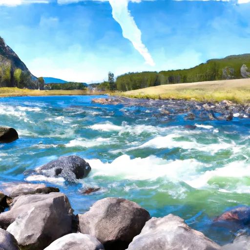
The Madison River is divided into several segments, each with its own unique characteristics. The Upper Madison, which starts at the West Yellowstone boundary and ends at the town of Ennis, is a popular section for beginner paddlers. It has several Class II rapids, including Eight Mile and Varney Bridge. The Middle Madison, from Ennis to the town of Three Forks, features more challenging rapids, including Class III rapids such as Kitchen Sink and Frog Rock. The Lower Madison, from Three Forks to the headwaters of the Missouri River, is a Class II section with a few Class III features.
The Madison River has several specific obstacles that paddlers should be aware of, including boulder gardens, wave trains, and tight channels. The river is also home to several fishing access points, and paddlers should be respectful of anglers and avoid disrupting their fishing experience.
There are specific regulations for the Madison River, including restrictions on the use of motorized watercraft and the requirement for all paddlers to wear life jackets. The river is also subject to seasonal closures and restrictions to protect nesting birds and other wildlife.
Overall, the Madison River is a popular and exciting whitewater run in Montana, offering a range of rapids and obstacles for paddlers of all skill levels to enjoy.
Plan your run down to the hour
Same weather feed Snoflo's iOS app uses -- updated continuously from NOAA / yr.no. Watch the precipitation column on the meteogram; rain ahead of a run typically lifts flows 12-48 hours later depending on the basin.
Next 5 days, hour by hour
Temperature line with weather symbols on top, snow + rain accumulation as columns, humidity as a dotted line.
5-day forecast table
Every 3 hours, broken out across temperature, snow, rain, humidity, and wind. Each cell is colour-coded relative to the column min/max.
| Time | Condition | Temp (°F) | Snow (in) | Rain (in) | Humidity (%) | Wind (mps) | Wind dir |
|---|---|---|---|---|---|---|---|
| Loading detailed forecast… | |||||||
15-day temperature & precipitation
Daily temperatures, snow, and rain projected over the next two weeks -- the upstream story that drives next week's flows.
Regional streamflow levels
USGS streamgauges around Madison River -- useful for spotting upstream pulses and gauging which tributary is contributing what.
| Streamgauge | Discharge | View |
|---|---|---|
| Madison River At Kirby Ranch Nr Cameron Mt | 1,320 cfs | → |
| Madison River Bl Hebgen Lake Nr Grayling Mt | 1,130 cfs | → |
| Madison River Near Cameron Mt | 1,400 cfs | → |
| Red Rock Cr Ab Lakes Nr Lakeview Mt | 35 cfs | → |
| Ruby River Ab Reservoir Nr Alder Mt | 116 cfs | → |
| Henrys Fork Nr Lake Id | 194 cfs | → |
Plan a longer trip
The closest boat launches, other paddle runs, and campgrounds so a day on the water can grow into a full weekend.
Boat launches
- Windy Point Boat Launch
- Palisades Day Use
- Lyons Bridge
- Ruby Creek Boat Launch
- Mcatee Bridge Madison County
- Mcatee Bridge
Campgrounds
- Wall Creek Cabin
- West Fork Madison
- West Fork Madison Campground
- Madison River
- Ruby Creek Campground
- Madison Campground
Fishing spots
Whitewater safety
- Check the flow before you run
- Use the linked-gauge card and Regional Flow panel above. Class ratings change with flow -- a Class III at low water can become Class IV+ at high water.
- Know your skill ceiling
- Pick runs comfortably below your ceiling. Cold-water and big-water runs raise the consequences of any mistake.
- Wear the right gear
- Helmet, PFD, drysuit / wetsuit when water is below 60°F. Throw bag, knife, and whistle on your person, not in the boat.
- Scout, set safety, and run with a team
- Scout new rapids on foot, set safety with throw bags above the consequence pool, and run with at least one other competent paddler.
- Respect the river
- Strainers, undercuts, low-head dams, and wood can kill at any class rating. When in doubt, portage.
Set push alerts in the Snoflo app
Save Madison River as a favorite, set a discharge threshold (e.g. "alert me when flow hits 600 cfs"), and the iOS app pushes the moment the linked gauge crosses.
About Madison River
What's the optimal flow for Madison River?
The optimal flow depends on the section and the craft. Check the Run Details panel for the linked gauge and current status.
How fresh is the cfs reading on this page?
The linked USGS streamgauge reports continuously (every 15 minutes); Snoflo refreshes throughout the day. Hover the streamflow sparkline to read individual datapoints.
What's the whitewater class?
See the Run Details panel for the class rating Snoflo tracks for this run. Class ratings change with flow -- a Class III at low water can become Class IV in high water.
Where do I put in / take out?
Tap Directions in the hero above to open driving directions to the put-in. For shuttle planning, check the Nearby Boat Launches panel and the river run operator's site.
Can I get alerts when flows hit the optimal range?
Yes -- alerts are managed in the Snoflo iOS app. Favorite this run, set a discharge threshold, and you'll get a push the moment the gauge crosses.
Other runs near here
Snoflo-tracked paddle runs within driving distance of Madison River.