Beaverhead River River Run
Community Reviews
Been here? Share the conditions.
Reviews, ratings & photos are added in the free Snoflo iOS app — rate a spot, tag the conditions, and your visit is verified by location. Add or manage your reviews from the app.
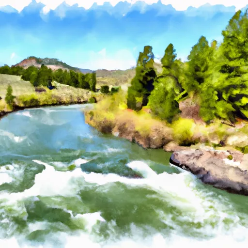
Beaverhead River
The river has a total segment mileage of 69 miles, with the whitewater section stretching from Clark Canyon Reservoir to Barrett's Diversion Dam, covering a distance of 15 miles. Rafters can expect to encounter several rapids and obstacles during this stretch, including the Beaver Slides and the Sinks.
The Beaver Slides are a series of class III rapids that offer fast-paced and exciting whitewater action. The Sinks, on the other hand, is a narrow section of the river that creates strong currents and challenging waves. Rafters should be prepared to navigate around rocks and boulders, as well as avoid low-hanging branches and other obstacles.
To ensure the safety of all visitors, specific regulations are in place for the Beaverhead River. All rafters must wear a U.S. Coast Guard-approved life jacket and follow the guidelines set forth by the Montana Fish, Wildlife, and Parks department. Additionally, visitors are reminded to leave no trace and respect the natural environment.
Overall, the Beaverhead River offers an exciting whitewater experience for rafters of all levels. With its moderate rapids, beautiful scenery, and specific regulations, it is a must-visit destination for any adventure seeker visiting Montana.
Plan your run down to the hour
Same weather feed Snoflo's iOS app uses -- updated continuously from NOAA / yr.no. Watch the precipitation column on the meteogram; rain ahead of a run typically lifts flows 12-48 hours later depending on the basin.
Next 5 days, hour by hour
Temperature line with weather symbols on top, snow + rain accumulation as columns, humidity as a dotted line.
5-day forecast table
Every 3 hours, broken out across temperature, snow, rain, humidity, and wind. Each cell is colour-coded relative to the column min/max.
| Time | Condition | Temp (°F) | Snow (in) | Rain (in) | Humidity (%) | Wind (mps) | Wind dir |
|---|---|---|---|---|---|---|---|
| Loading detailed forecast… | |||||||
15-day temperature & precipitation
Daily temperatures, snow, and rain projected over the next two weeks -- the upstream story that drives next week's flows.
Regional streamflow levels
USGS streamgauges around Beaverhead River -- useful for spotting upstream pulses and gauging which tributary is contributing what.
| Streamgauge | Discharge | View |
|---|---|---|
| Beaverhead River At Barretts Mt | 541 cfs | → |
| Beaverhead River At Dillon Mt | 112 cfs | → |
| Beaverhead River Near Twin Bridges Mt | 85 cfs | → |
| Big Hole River Near Glen Mt | 739 cfs | → |
| Big Hole River Near Melrose Mt | 837 cfs | → |
| Ruby River Ab Reservoir Nr Alder Mt | 101 cfs | → |
Plan a longer trip
The closest boat launches, other paddle runs, and campgrounds so a day on the water can grow into a full weekend.
Boat launches
Other river runs
Whitewater safety
- Check the flow before you run
- Use the linked-gauge card and Regional Flow panel above. Class ratings change with flow -- a Class III at low water can become Class IV+ at high water.
- Know your skill ceiling
- Pick runs comfortably below your ceiling. Cold-water and big-water runs raise the consequences of any mistake.
- Wear the right gear
- Helmet, PFD, drysuit / wetsuit when water is below 60°F. Throw bag, knife, and whistle on your person, not in the boat.
- Scout, set safety, and run with a team
- Scout new rapids on foot, set safety with throw bags above the consequence pool, and run with at least one other competent paddler.
- Respect the river
- Strainers, undercuts, low-head dams, and wood can kill at any class rating. When in doubt, portage.
Set push alerts in the Snoflo app
Save Beaverhead River as a favorite, set a discharge threshold (e.g. "alert me when flow hits 600 cfs"), and the iOS app pushes the moment the linked gauge crosses.
About Beaverhead River
What's the optimal flow for Beaverhead River?
The optimal flow depends on the section and the craft. Check the Run Details panel for the linked gauge and current status.
How fresh is the cfs reading on this page?
The linked USGS streamgauge reports continuously (every 15 minutes); Snoflo refreshes throughout the day. Hover the streamflow sparkline to read individual datapoints.
What's the whitewater class?
See the Run Details panel for the class rating Snoflo tracks for this run. Class ratings change with flow -- a Class III at low water can become Class IV in high water.
Where do I put in / take out?
Tap Directions in the hero above to open driving directions to the put-in. For shuttle planning, check the Nearby Boat Launches panel and the river run operator's site.
Can I get alerts when flows hit the optimal range?
Yes -- alerts are managed in the Snoflo iOS app. Favorite this run, set a discharge threshold, and you'll get a push the moment the gauge crosses.
Other runs near here
Snoflo-tracked paddle runs within driving distance of Beaverhead River.