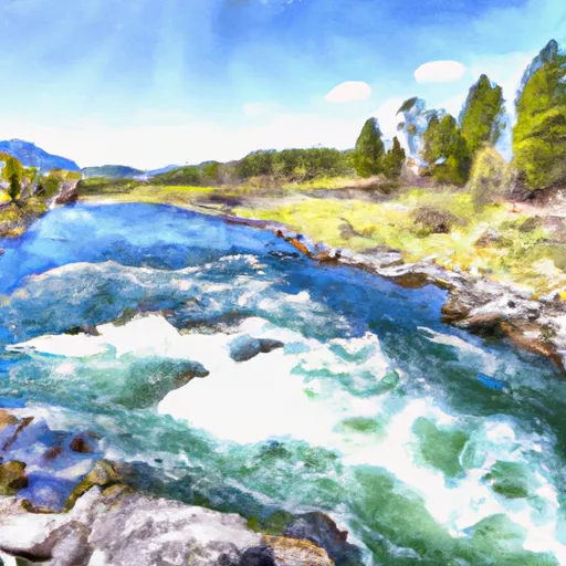
Madison River River Run
Community Reviews
Been here? Share the conditions.
Reviews, ratings & photos are added in the free Snoflo iOS app — rate a spot, tag the conditions, and your visit is verified by location. Add or manage your reviews from the app.
Madison River
The river run is divided into three segments: the upper, middle, and lower sections. The upper section is approximately 19 miles and runs from the West Fork of the Madison River to McAtee Bridge. It is known for its scenic views and technical rapids such as the Kitchen Sink and Ennis Falls. The middle section is 21 miles and runs from McAtee Bridge to Warm Springs. It is characterized by boulder-strewn rapids and waves, including the famous "Brennan's Wave" near Bozeman. The lower section is 22 miles and runs from Warm Springs to Three Forks. It is a calmer segment with occasional rapids and stunning views of the surrounding canyon.
Specific regulations to the area include a fishing closure from the Madison Dam to Ennis Lake during the months of March and April to protect spawning rainbow trout. Boaters are required to have a permit for commercial trips and are limited to a maximum of 24 passengers per day. Additionally, there is a 5-mile per hour speed limit for motorized boats on the river.
Plan your run down to the hour
Same weather feed Snoflo's iOS app uses -- updated continuously from NOAA / yr.no. Watch the precipitation column on the meteogram; rain ahead of a run typically lifts flows 12-48 hours later depending on the basin.
Next 5 days, hour by hour
Temperature line with weather symbols on top, snow + rain accumulation as columns, humidity as a dotted line.
5-day forecast table
Every 3 hours, broken out across temperature, snow, rain, humidity, and wind. Each cell is colour-coded relative to the column min/max.
| Time | Condition | Temp (°F) | Snow (in) | Rain (in) | Humidity (%) | Wind (mps) | Wind dir |
|---|---|---|---|---|---|---|---|
| Loading detailed forecast… | |||||||
15-day temperature & precipitation
Daily temperatures, snow, and rain projected over the next two weeks -- the upstream story that drives next week's flows.
Regional streamflow levels
USGS streamgauges around Madison River -- useful for spotting upstream pulses and gauging which tributary is contributing what.
| Streamgauge | Discharge | View |
|---|---|---|
| Madison River At Kirby Ranch Nr Cameron Mt | 1,320 cfs | → |
| Madison River Near Cameron Mt | 1,370 cfs | → |
| Madison River Bl Hebgen Lake Nr Grayling Mt | 1,190 cfs | → |
| Ruby River Ab Reservoir Nr Alder Mt | 86 cfs | → |
| Ruby River Bl Reservoir Nr Alder Mt | 265 cfs | → |
| Madison River Ab Powerplant Nr Mcallister Mt | 111 cfs | → |
Plan a longer trip
The closest boat launches, other paddle runs, and campgrounds so a day on the water can grow into a full weekend.
Boat launches
- Ruby Creek Boat Launch
- Mcatee Bridge Madison County
- Mcatee Bridge
- Madison County
- Palisades Day Use
- Storey Ditch Boat Launch
Campgrounds
- Ruby Creek Campground
- Wall Creek Cabin
- Clover Meadows Dispersed Camping And Picnic Area
- Bear Creek Bunkhouse
- Bear Creek Cabin
- Bear Creek Campground And Picnic Area
Fishing spots
Whitewater safety
- Check the flow before you run
- Use the linked-gauge card and Regional Flow panel above. Class ratings change with flow -- a Class III at low water can become Class IV+ at high water.
- Know your skill ceiling
- Pick runs comfortably below your ceiling. Cold-water and big-water runs raise the consequences of any mistake.
- Wear the right gear
- Helmet, PFD, drysuit / wetsuit when water is below 60°F. Throw bag, knife, and whistle on your person, not in the boat.
- Scout, set safety, and run with a team
- Scout new rapids on foot, set safety with throw bags above the consequence pool, and run with at least one other competent paddler.
- Respect the river
- Strainers, undercuts, low-head dams, and wood can kill at any class rating. When in doubt, portage.
Set push alerts in the Snoflo app
Save Madison River as a favorite, set a discharge threshold (e.g. "alert me when flow hits 600 cfs"), and the iOS app pushes the moment the linked gauge crosses.
About Madison River
What's the optimal flow for Madison River?
The optimal flow depends on the section and the craft. Check the Run Details panel for the linked gauge and current status.
How fresh is the cfs reading on this page?
The linked USGS streamgauge reports continuously (every 15 minutes); Snoflo refreshes throughout the day. Hover the streamflow sparkline to read individual datapoints.
What's the whitewater class?
See the Run Details panel for the class rating Snoflo tracks for this run. Class ratings change with flow -- a Class III at low water can become Class IV in high water.
Where do I put in / take out?
Tap Directions in the hero above to open driving directions to the put-in. For shuttle planning, check the Nearby Boat Launches panel and the river run operator's site.
Can I get alerts when flows hit the optimal range?
Yes -- alerts are managed in the Snoflo iOS app. Favorite this run, set a discharge threshold, and you'll get a push the moment the gauge crosses.
Other runs near here
Snoflo-tracked paddle runs within driving distance of Madison River.