Source To Confluence With Metolius River River Run
Community Reviews
Been here? Share the conditions.
Reviews, ratings & photos are added in the free Snoflo iOS app — rate a spot, tag the conditions, and your visit is verified by location. Add or manage your reviews from the app.
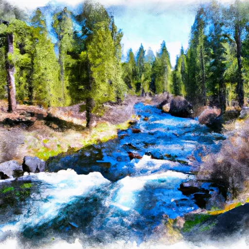
Source To Confluence With Metolius River
The river begins at the Whitewater Glacier in the Cascade Range and flows for 31 miles before joining with the Metolius River. The segment mileage varies depending on where you put in and take out, but most trips cover around 12-15 miles.
Some of the notable rapids and obstacles on the Whitewater River Run include Rattlesnake, Deadman's, and Gash Rapid. These are all Class IV rapids that require skill and experience to navigate safely. The river also features several Class III rapids that provide exciting but manageable challenges for intermediate paddlers.
In terms of regulations, the Whitewater River Run is located within the Mt. Jefferson Wilderness Area, which means that visitors are required to follow Leave No Trace principles and obtain a permit for overnight trips. Additionally, motorized boats are not allowed on the river, and visitors are expected to pack out all trash and waste.
Overall, the Whitewater River Run is a thrilling and challenging destination for whitewater enthusiasts. It is important to check streamflow levels and be prepared for the Class IV rapids before embarking on this adventure.
Plan your run down to the hour
Same weather feed Snoflo's iOS app uses -- updated continuously from NOAA / yr.no. Watch the precipitation column on the meteogram; rain ahead of a run typically lifts flows 12-48 hours later depending on the basin.
Next 5 days, hour by hour
Temperature line with weather symbols on top, snow + rain accumulation as columns, humidity as a dotted line.
5-day forecast table
Every 3 hours, broken out across temperature, snow, rain, humidity, and wind. Each cell is colour-coded relative to the column min/max.
| Time | Condition | Temp (°F) | Snow (in) | Rain (in) | Humidity (%) | Wind (mps) | Wind dir |
|---|---|---|---|---|---|---|---|
| Loading detailed forecast… | |||||||
15-day temperature & precipitation
Daily temperatures, snow, and rain projected over the next two weeks -- the upstream story that drives next week's flows.
Regional streamflow levels
USGS streamgauges around Source To Confluence With Metolius River -- useful for spotting upstream pulses and gauging which tributary is contributing what.
| Streamgauge | Discharge | View |
|---|---|---|
| Metolius River Near Grandview | 1,230 cfs | → |
| Deschutes River Near Culver | 518 cfs | → |
| Crooked River Below Opal Springs | 1,210 cfs | → |
| Shitike Cr | 29 cfs | → |
| Mckenzie River At Outlet Of Clear Lake | 157 cfs | → |
| Crooked River Blw Osborne Canyon | 98 cfs | → |
Plan a longer trip
The closest boat launches, other paddle runs, and campgrounds so a day on the water can grow into a full weekend.
Boat launches
Other river runs
- Headwaters To Mt Jefferson Wilderness Boundary
- Crooked River National Grassland Boundary To Confluence With Deschutes River
- Mt. Jefferson Wilderness Boundary To Highway 22
- Canyon Run (Lower Bridge To Billy Chinook Res.)
- Russel Lake To Mt. Jefferson Wilderness Boundary
Campgrounds
- Lower Canyon Creek Campground
- Gorge Campground
- Gorge
- Pine Rest Campground
- Pine Rest
- Smiling River Campground
Whitewater safety
- Check the flow before you run
- Use the linked-gauge card and Regional Flow panel above. Class ratings change with flow -- a Class III at low water can become Class IV+ at high water.
- Know your skill ceiling
- Pick runs comfortably below your ceiling. Cold-water and big-water runs raise the consequences of any mistake.
- Wear the right gear
- Helmet, PFD, drysuit / wetsuit when water is below 60°F. Throw bag, knife, and whistle on your person, not in the boat.
- Scout, set safety, and run with a team
- Scout new rapids on foot, set safety with throw bags above the consequence pool, and run with at least one other competent paddler.
- Respect the river
- Strainers, undercuts, low-head dams, and wood can kill at any class rating. When in doubt, portage.
Set push alerts in the Snoflo app
Save Source To Confluence With Metolius River as a favorite, set a discharge threshold (e.g. "alert me when flow hits 600 cfs"), and the iOS app pushes the moment the linked gauge crosses.
About Source To Confluence With Metolius River
What's the optimal flow for Source To Confluence With Metolius River?
The optimal flow depends on the section and the craft. Check the Run Details panel for the linked gauge and current status.
How fresh is the cfs reading on this page?
The linked USGS streamgauge reports continuously (every 15 minutes); Snoflo refreshes throughout the day. Hover the streamflow sparkline to read individual datapoints.
What's the whitewater class?
See the Run Details panel for the class rating Snoflo tracks for this run. Class ratings change with flow -- a Class III at low water can become Class IV in high water.
Where do I put in / take out?
Tap Directions in the hero above to open driving directions to the put-in. For shuttle planning, check the Nearby Boat Launches panel and the river run operator's site.
Can I get alerts when flows hit the optimal range?
Yes -- alerts are managed in the Snoflo iOS app. Favorite this run, set a discharge threshold, and you'll get a push the moment the gauge crosses.
Other runs near here
Snoflo-tracked paddle runs within driving distance of Source To Confluence With Metolius River.