Rogue-Umpqua Wilderness Boundary To Confluence With North Fork Rogue River River Run
Community Reviews
Been here? Share the conditions.
Reviews, ratings & photos are added in the free Snoflo iOS app — rate a spot, tag the conditions, and your visit is verified by location. Add or manage your reviews from the app.
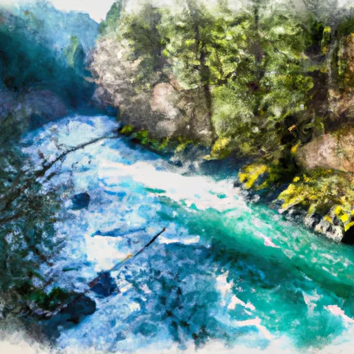
Rogue-Umpqua Wilderness Boundary To Confluence With North Fork Rogue River
Some of the notable rapids and obstacles on this section include Rainie Falls, a class V rapid with a tricky line and a large hydraulic at the bottom, Blossom Bar, a class IV rapid with a narrow chute and a large hole at the bottom, and Upper and Lower Black Bar Falls, two class IV drops that can be portaged if necessary.
There are several regulations to be aware of when planning a trip on the Rogue River. Permits are required for all overnight trips, and campsites must be reserved in advance. Fires are not allowed except in designated fire rings, and all waste must be packed out. Additionally, there are fishing restrictions in certain areas to protect native fish populations.
Plan your run down to the hour
Same weather feed Snoflo's iOS app uses -- updated continuously from NOAA / yr.no. Watch the precipitation column on the meteogram; rain ahead of a run typically lifts flows 12-48 hours later depending on the basin.
Next 5 days, hour by hour
Temperature line with weather symbols on top, snow + rain accumulation as columns, humidity as a dotted line.
5-day forecast table
Every 3 hours, broken out across temperature, snow, rain, humidity, and wind. Each cell is colour-coded relative to the column min/max.
| Time | Condition | Temp (°F) | Snow (in) | Rain (in) | Humidity (%) | Wind (mps) | Wind dir |
|---|---|---|---|---|---|---|---|
| Loading detailed forecast… | |||||||
15-day temperature & precipitation
Daily temperatures, snow, and rain projected over the next two weeks -- the upstream story that drives next week's flows.
Regional streamflow levels
USGS streamgauges around Rogue-Umpqua Wilderness Boundary To Confluence With North Fork Rogue River -- useful for spotting upstream pulses and gauging which tributary is contributing what.
| Streamgauge | Discharge | View |
|---|---|---|
| Fish Creek Abv Slipper Creek Nr Toketee Falls | 41 cfs | → |
| Lake Creek Near Diamond | 113 cfs | → |
| Clearwater R Ab Trap Cr Nr T Falls | 52 cfs | → |
| Clearwater R Blw Mowich Creek | 50 cfs | → |
| North Umpqua River At Toketee Falls Oreg. | 91 cfs | → |
| N.Umpqua R Blw Slide Ck Dam Nr Toketee Falls | 263 cfs | → |
Plan a longer trip
The closest boat launches, other paddle runs, and campgrounds so a day on the water can grow into a full weekend.
Boat launches
- South Shore - Diamond Lake
- South Shore Boating Site (Diamond Lake)
- Thielsen View
- Diamond Lake Campground - M Loop
- Diamond Lake Campground - C Loop
- North End Boat Ramp
Other river runs
- Headwaters To Rogue-Umpqua Wilderness Boundary
- Headwaters To Confluence Of Foster Creek
- Crater Lake Np Boundary To Confluence With Rogue River
- Headwaters To Confluence With Rogue River
- Headwaters To Boulder Creek Wilderness Boundary
Campgrounds
Whitewater safety
- Check the flow before you run
- Use the linked-gauge card and Regional Flow panel above. Class ratings change with flow -- a Class III at low water can become Class IV+ at high water.
- Know your skill ceiling
- Pick runs comfortably below your ceiling. Cold-water and big-water runs raise the consequences of any mistake.
- Wear the right gear
- Helmet, PFD, drysuit / wetsuit when water is below 60°F. Throw bag, knife, and whistle on your person, not in the boat.
- Scout, set safety, and run with a team
- Scout new rapids on foot, set safety with throw bags above the consequence pool, and run with at least one other competent paddler.
- Respect the river
- Strainers, undercuts, low-head dams, and wood can kill at any class rating. When in doubt, portage.
Set push alerts in the Snoflo app
Save Rogue-Umpqua Wilderness Boundary To Confluence With North Fork Rogue River as a favorite, set a discharge threshold (e.g. "alert me when flow hits 600 cfs"), and the iOS app pushes the moment the linked gauge crosses.
About Rogue-Umpqua Wilderness Boundary To Confluence With North Fork Rogue River
What's the optimal flow for Rogue-Umpqua Wilderness Boundary To Confluence With North Fork Rogue River?
The optimal flow depends on the section and the craft. Check the Run Details panel for the linked gauge and current status.
How fresh is the cfs reading on this page?
The linked USGS streamgauge reports continuously (every 15 minutes); Snoflo refreshes throughout the day. Hover the streamflow sparkline to read individual datapoints.
What's the whitewater class?
See the Run Details panel for the class rating Snoflo tracks for this run. Class ratings change with flow -- a Class III at low water can become Class IV in high water.
Where do I put in / take out?
Tap Directions in the hero above to open driving directions to the put-in. For shuttle planning, check the Nearby Boat Launches panel and the river run operator's site.
Can I get alerts when flows hit the optimal range?
Yes -- alerts are managed in the Snoflo iOS app. Favorite this run, set a discharge threshold, and you'll get a push the moment the gauge crosses.
Other runs near here
Snoflo-tracked paddle runs within driving distance of Rogue-Umpqua Wilderness Boundary To Confluence With North Fork Rogue River.