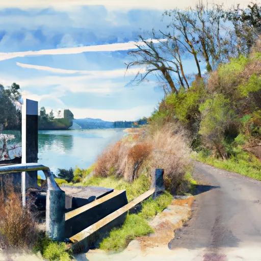
Davis Creek boat launch
Community Reviews
Been here? Share the conditions.
Reviews, ratings & photos are added in the free Snoflo iOS app — rate a spot, tag the conditions, and your visit is verified by location. Add or manage your reviews from the app.
Davis Creek
The Davis Creek boat ramp is approximately 20 feet wide which is enough for most boats to launch and retrieve safely. It services the Davis Lake which is a popular destination for boating and fishing enthusiasts in the region. The lake is approximately 3 miles long and 1 mile wide, and is situated at an elevation of 6,350 feet.
As for the kind of craft permitted on the water, the latest information indicates that motorized boats are allowed on Davis Lake, but they must comply with strict boating regulations. The speed limit on the lake is 10 mph and boats must maintain a safe distance from other boats and shorelines. Fishing boats, kayaks, canoes, and paddleboards are also permitted on the water.
In summary, the Davis Creek boat ramp is a concrete ramp located in Oregon that services the Davis Lake. It is approximately 20 feet wide and allows for the launching and retrieval of most boats. Motorized boats are allowed on the lake, but must adhere to strict boating regulations, and other types of watercraft are also permitted.
Plan your launch down to the hour
Same weather feed Snoflo's iOS app uses -- updated continuously from NOAA / yr.no.
Next 5 days, hour by hour
Temperature line with weather symbols on top, snow + rain accumulation as columns, humidity as a dotted line.
5-day forecast table
Every 3 hours, broken out across temperature, snow, rain, humidity, and wind.
| Time | Condition | Temp (°F) | Snow (in) | Rain (in) | Humidity (%) | Wind (mps) | Wind dir |
|---|---|---|---|---|---|---|---|
| Loading detailed forecast… | |||||||
15-day temperature & precipitation
Daily temperatures, snow, and rain projected over the next two weeks.
Area streamflow levels
USGS streamgauges around Davis Creek -- the same readings that determine whether your launch is safe and your boat is the right craft.
| Streamgauge | Discharge | View |
|---|---|---|
| N.Umpqua R Abv White Mule Ck | 89 cfs | → |
| North Umpqua R Bl Lemolo Lk Nr T Falls | 87 cfs | → |
| N.Umpqua R Blw Warm Springs Ck Nr Toketee Falls | 91 cfs | → |
| M F Willamette R Ab Salt Cr. | 556 cfs | → |
Plan a longer trip
The closest paddle runs, fishing spots, and other boat launches so you can extend a day on the water.
River runs
- Springs Sec 30, T21s, R8e To Wickiup Reservoir
- Wickiup Dam To Pringle Falls Campground
- Little Lava Lake To Crane Prairie Reservoir
- Pringle Falls To Big River Campground
- Roseland Park To Deschutes River
- Source To Confluence With Deschutes River
Nearby fishing
Boating safety & etiquette
- Check the conditions before you launch
- Use the streamflow numbers, weather, and wind forecast on this page. High-cfs whitewater requires whitewater-specific craft and skill.
- Wear your life jacket
- Statistically the single biggest survival factor in a boating incident. State law often requires one per passenger.
- File a float plan
- Tell someone on shore your put-in, take-out, and expected return time. Especially for multi-day or remote trips.
- Yield at the ramp
- Prep gear in the parking lot, not on the ramp. Launch and clear quickly so others can use the lane.
- Clean, drain, dry
- Inspect, clean, drain and dry your boat between waters to prevent the spread of aquatic invasive species.
Set push alerts in the Snoflo app
Save Davis Creek as a favorite, set a discharge threshold or a wind/precipitation alert, and the iOS app will push the moment conditions cross.
About Davis Creek
Can I launch a motorboat here?
Most Snoflo-tracked launches support motorboats; check the operator for any horsepower restrictions, paddle-only zones, or seasonal closures.
How fresh is the streamflow data?
USGS streamgauges report continuously (every 15 minutes); the table on this page pulls the latest reading at page load.
Is there a fee?
Many federal and state boat launches charge a day-use fee. Check the operator's site before driving out.
What boat is right for these conditions?
Use the nearby streamflow numbers and river-run panel on this page to gauge current conditions. Wider, slower water is friendly for casual paddling and powerboats; high-cfs whitewater requires whitewater-specific craft and skill.
Can I get alerts when conditions change?
Yes -- alerts are managed in the Snoflo iOS app. Favorite this launch, set a threshold (discharge, wind), and you'll get a push the moment it crosses.
Other launches near here
Snoflo-tracked boat launches within driving distance of Davis Creek.