Headwaters To Confluence With Rogue River River Run
Community Reviews
Been here? Share the conditions.
Reviews, ratings & photos are added in the free Snoflo iOS app — rate a spot, tag the conditions, and your visit is verified by location. Add or manage your reviews from the app.
Headwaters To Confluence With Rogue River
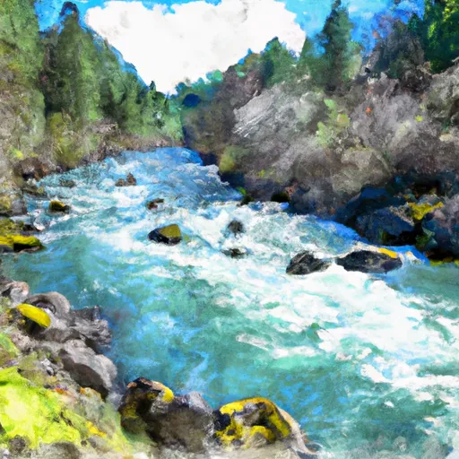
One of the most challenging rapids in this run is called The Chutes, which is a Class IV rapid due to its steep drops and strong currents. Another challenging section is the Powerhouse Rapids, which is a Class III rapid that requires precise paddling skills.
As for regulations, the area is managed by the Bureau of Land Management and requires permits for overnight camping. Additionally, there are strict rules regarding camping, fires, and littering to ensure the preservation of the natural environment. Paddlers are also required to wear personal flotation devices and helmets for their own safety.
Overall, the Whitewater River run from Headwaters to Confluence with Rogue River in Oregon is a thrilling and challenging adventure that requires skill and experience. It is important to follow all regulations and safety guidelines to ensure a safe and enjoyable experience.
Plan your run down to the hour
Same weather feed Snoflo's iOS app uses -- updated continuously from NOAA / yr.no. Watch the precipitation column on the meteogram; rain ahead of a run typically lifts flows 12-48 hours later depending on the basin.
Next 5 days, hour by hour
Temperature line with weather symbols on top, snow + rain accumulation as columns, humidity as a dotted line.
5-day forecast table
Every 3 hours, broken out across temperature, snow, rain, humidity, and wind. Each cell is colour-coded relative to the column min/max.
| Time | Condition | Temp (°F) | Snow (in) | Rain (in) | Humidity (%) | Wind (mps) | Wind dir |
|---|---|---|---|---|---|---|---|
| Loading detailed forecast… | |||||||
15-day temperature & precipitation
Daily temperatures, snow, and rain projected over the next two weeks -- the upstream story that drives next week's flows.
Regional streamflow levels
USGS streamgauges around Headwaters To Confluence With Rogue River -- useful for spotting upstream pulses and gauging which tributary is contributing what.
| Streamgauge | Discharge | View |
|---|---|---|
| South Fork Rogue River Near Prospect | 38 cfs | → |
| Rogue River Above Prospect | 811 cfs | → |
| Rogue River Below Prospect | 583 cfs | → |
| Rogue R At Cole M Rivers F Hatchery Nr Mcleod | 1,070 cfs | → |
| Big Butte Creek Near Mcleod | 27 cfs | → |
| Sevenmile Cnl At Dike Rd Br | 45 cfs | → |
Plan a longer trip
The closest boat launches, other paddle runs, and campgrounds so a day on the water can grow into a full weekend.
Other river runs
- Headwaters To Sw1/4 Of Sec 1, T33s, R4e
- Sw1/4 Of Sec 1, T33s, R4e To Rogue River Nf Boundary
- Crater Lake Np Boundary To Confluence With Rogue River
- Headwaters To Confluence Of Foster Creek
- Rogue-Umpqua Wilderness Boundary To Confluence With North Fork Rogue River
Campgrounds
- Huckleberry City
- Bessie Shelter Horse Camp
- Mazama - Crater Lake National Park
- Mazama Campground
- Dutton Camp
- Imnaha
Whitewater safety
- Check the flow before you run
- Use the linked-gauge card and Regional Flow panel above. Class ratings change with flow -- a Class III at low water can become Class IV+ at high water.
- Know your skill ceiling
- Pick runs comfortably below your ceiling. Cold-water and big-water runs raise the consequences of any mistake.
- Wear the right gear
- Helmet, PFD, drysuit / wetsuit when water is below 60°F. Throw bag, knife, and whistle on your person, not in the boat.
- Scout, set safety, and run with a team
- Scout new rapids on foot, set safety with throw bags above the consequence pool, and run with at least one other competent paddler.
- Respect the river
- Strainers, undercuts, low-head dams, and wood can kill at any class rating. When in doubt, portage.
Set push alerts in the Snoflo app
Save Headwaters To Confluence With Rogue River as a favorite, set a discharge threshold (e.g. "alert me when flow hits 600 cfs"), and the iOS app pushes the moment the linked gauge crosses.
About Headwaters To Confluence With Rogue River
What's the optimal flow for Headwaters To Confluence With Rogue River?
The optimal flow depends on the section and the craft. Check the Run Details panel for the linked gauge and current status.
How fresh is the cfs reading on this page?
The linked USGS streamgauge reports continuously (every 15 minutes); Snoflo refreshes throughout the day. Hover the streamflow sparkline to read individual datapoints.
What's the whitewater class?
See the Run Details panel for the class rating Snoflo tracks for this run. Class ratings change with flow -- a Class III at low water can become Class IV in high water.
Where do I put in / take out?
Tap Directions in the hero above to open driving directions to the put-in. For shuttle planning, check the Nearby Boat Launches panel and the river run operator's site.
Can I get alerts when flows hit the optimal range?
Yes -- alerts are managed in the Snoflo iOS app. Favorite this run, set a discharge threshold, and you'll get a push the moment the gauge crosses.
Other runs near here
Snoflo-tracked paddle runs within driving distance of Headwaters To Confluence With Rogue River.