Middle Of Sec 15, T39s, R4e To Confluence With Canyon Creek River Run
Community Reviews
Been here? Share the conditions.
Reviews, ratings & photos are added in the free Snoflo iOS app — rate a spot, tag the conditions, and your visit is verified by location. Add or manage your reviews from the app.
Middle Of Sec 15, T39s, R4e To Confluence With Canyon Creek
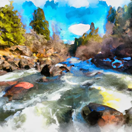
The Middle Fork of the John Day River is classified as a class III-IV river, with several challenging rapids and obstacles to navigate, including Twister, Zinger, and Devil's Staircase. The river is best suited for experienced kayakers and rafters, as the rapids can be difficult to maneuver.
There are specific regulations in place for the Whitewater River Run, including a permit system for overnight camping and a limit on the number of people allowed on the river at one time. It is important for visitors to familiarize themselves with these regulations before embarking on their whitewater adventure.
Overall, the Middle Fork of the John Day River provides an exciting and challenging whitewater experience for experienced paddlers. However, it is important to always prioritize safety and follow regulations to protect the natural beauty of the area.
Plan your run down to the hour
Same weather feed Snoflo's iOS app uses -- updated continuously from NOAA / yr.no. Watch the precipitation column on the meteogram; rain ahead of a run typically lifts flows 12-48 hours later depending on the basin.
Next 5 days, hour by hour
Temperature line with weather symbols on top, snow + rain accumulation as columns, humidity as a dotted line.
5-day forecast table
Every 3 hours, broken out across temperature, snow, rain, humidity, and wind. Each cell is colour-coded relative to the column min/max.
| Time | Condition | Temp (°F) | Snow (in) | Rain (in) | Humidity (%) | Wind (mps) | Wind dir |
|---|---|---|---|---|---|---|---|
| Loading detailed forecast… | |||||||
15-day temperature & precipitation
Daily temperatures, snow, and rain projected over the next two weeks -- the upstream story that drives next week's flows.
Regional streamflow levels
USGS streamgauges around Middle Of Sec 15, T39s, R4e To Confluence With Canyon Creek -- useful for spotting upstream pulses and gauging which tributary is contributing what.
| Streamgauge | Discharge | View |
|---|---|---|
| Illinois River Near Kerby | 27 cfs | → |
| Sucker Cr Bl Lt Grayback Cr Nr Holland | 20 cfs | → |
| Applegate River Near Wilderville | 73 cfs | → |
| Chetco River Near Brookings | 70 cfs | → |
| Rogue River At Grants Pass | 1,190 cfs | → |
| Indian C Nr Happy Camp Ca | 40 cfs | → |
Plan a longer trip
The closest boat launches, other paddle runs, and campgrounds so a day on the water can grow into a full weekend.
Boat launches
Other river runs
- Confluence With Lightening Gulch To Confluence With Josephine Creek
- Headwaters To Middle Of Sec 15, T39s, R4e
- Confluence Of North And South Forks Rough And Ready To Middle Of Sec 15, T40s, R9w
- Middle Of Sec 15, T40s, R4e To Siskyou Nf Boundary (East Section Line Of Sec 13, T40s, R4e)
- Headwaters Including Both Unnamed Forks And Rr Lakes To Confluence With Rough And Ready Creek
Campgrounds
- Ol Jo Rv Campground
- Josephine Creek Camp
- Josephine Campground
- Josephine Creek Campground
- Little Falls Campground
- Shady Acres
Whitewater safety
- Check the flow before you run
- Use the linked-gauge card and Regional Flow panel above. Class ratings change with flow -- a Class III at low water can become Class IV+ at high water.
- Know your skill ceiling
- Pick runs comfortably below your ceiling. Cold-water and big-water runs raise the consequences of any mistake.
- Wear the right gear
- Helmet, PFD, drysuit / wetsuit when water is below 60°F. Throw bag, knife, and whistle on your person, not in the boat.
- Scout, set safety, and run with a team
- Scout new rapids on foot, set safety with throw bags above the consequence pool, and run with at least one other competent paddler.
- Respect the river
- Strainers, undercuts, low-head dams, and wood can kill at any class rating. When in doubt, portage.
Set push alerts in the Snoflo app
Save Middle Of Sec 15, T39s, R4e To Confluence With Canyon Creek as a favorite, set a discharge threshold (e.g. "alert me when flow hits 600 cfs"), and the iOS app pushes the moment the linked gauge crosses.
About Middle Of Sec 15, T39s, R4e To Confluence With Canyon Creek
What's the optimal flow for Middle Of Sec 15, T39s, R4e To Confluence With Canyon Creek?
The optimal flow depends on the section and the craft. Check the Run Details panel for the linked gauge and current status.
How fresh is the cfs reading on this page?
The linked USGS streamgauge reports continuously (every 15 minutes); Snoflo refreshes throughout the day. Hover the streamflow sparkline to read individual datapoints.
What's the whitewater class?
See the Run Details panel for the class rating Snoflo tracks for this run. Class ratings change with flow -- a Class III at low water can become Class IV in high water.
Where do I put in / take out?
Tap Directions in the hero above to open driving directions to the put-in. For shuttle planning, check the Nearby Boat Launches panel and the river run operator's site.
Can I get alerts when flows hit the optimal range?
Yes -- alerts are managed in the Snoflo iOS app. Favorite this run, set a discharge threshold, and you'll get a push the moment the gauge crosses.
Other runs near here
Snoflo-tracked paddle runs within driving distance of Middle Of Sec 15, T39s, R4e To Confluence With Canyon Creek.