County Boudary (Confluence With Wsr) To Rm 47 (Lower End Mcguire Reservoir) River Run
Community Reviews
Been here? Share the conditions.
Reviews, ratings & photos are added in the free Snoflo iOS app — rate a spot, tag the conditions, and your visit is verified by location. Add or manage your reviews from the app.
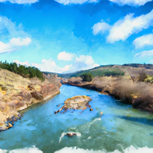
County Boudary (Confluence With Wsr) To Rm 47 (Lower End Mcguire Reservoir)
During this segment, paddlers will encounter a series of challenging rapids, including Double Drop, Boxcar, and Oak Springs. These rapids require precise maneuvering and a high level of skill to navigate safely. The river also features a number of obstacles, such as fallen trees and large boulders, which require paddlers to stay alert and maintain good control of their craft at all times.
To ensure the safety of all paddlers, there are specific regulations in place for this segment of the river. All paddlers are required to wear personal flotation devices (PFDs) at all times while on the water, and they must also carry a whistle and a signal mirror. Additionally, motorized boats are not allowed on this segment of the river.
In conclusion, the Whitewater River Run County Boundary to RM 47 segment of the Lower Deschutes River is a thrilling and challenging run for experienced paddlers. With its class III-IV rating, challenging rapids, and specific regulations, it is important for paddlers to be well-prepared and have the necessary skills and equipment to navigate this stretch of river safely.
Plan your run down to the hour
Same weather feed Snoflo's iOS app uses -- updated continuously from NOAA / yr.no. Watch the precipitation column on the meteogram; rain ahead of a run typically lifts flows 12-48 hours later depending on the basin.
Next 5 days, hour by hour
Temperature line with weather symbols on top, snow + rain accumulation as columns, humidity as a dotted line.
5-day forecast table
Every 3 hours, broken out across temperature, snow, rain, humidity, and wind. Each cell is colour-coded relative to the column min/max.
| Time | Condition | Temp (°F) | Snow (in) | Rain (in) | Humidity (%) | Wind (mps) | Wind dir |
|---|---|---|---|---|---|---|---|
| Loading detailed forecast… | |||||||
15-day temperature & precipitation
Daily temperatures, snow, and rain projected over the next two weeks -- the upstream story that drives next week's flows.
Regional streamflow levels
USGS streamgauges around County Boudary (Confluence With Wsr) To Rm 47 (Lower End Mcguire Reservoir) -- useful for spotting upstream pulses and gauging which tributary is contributing what.
| Streamgauge | Discharge | View |
|---|---|---|
| Tucca Creek Near Blaine | 2 cfs | → |
| South Yamhill River At Mcminnville | 48 cfs | → |
| Trask River Above Cedar Creek | 122 cfs | → |
| Tualatin River Near Dilley | 199 cfs | → |
| Wilson River Near Tillamook | 115 cfs | → |
| Nestucca River Near Beaver | 122 cfs | → |
Plan a longer trip
The closest boat launches, other paddle runs, and campgrounds so a day on the water can grow into a full weekend.
Boat launches
Other river runs
- Rm 47 To Rm 52 (Upper End Of Nestucca River)
- Nestucca River Seg B
- Tualatin River
- North Fork Trask River
- South Fork Trask River
Campgrounds
- Dovre Campground
- Fan Creek Campground
- Camp Cooper (Bsa Cascade Pacific Council)
- Elk Bend Campground
- Alder Glen Campground
- Rocky Bend
Whitewater safety
- Check the flow before you run
- Use the linked-gauge card and Regional Flow panel above. Class ratings change with flow -- a Class III at low water can become Class IV+ at high water.
- Know your skill ceiling
- Pick runs comfortably below your ceiling. Cold-water and big-water runs raise the consequences of any mistake.
- Wear the right gear
- Helmet, PFD, drysuit / wetsuit when water is below 60°F. Throw bag, knife, and whistle on your person, not in the boat.
- Scout, set safety, and run with a team
- Scout new rapids on foot, set safety with throw bags above the consequence pool, and run with at least one other competent paddler.
- Respect the river
- Strainers, undercuts, low-head dams, and wood can kill at any class rating. When in doubt, portage.
Set push alerts in the Snoflo app
Save County Boudary (Confluence With Wsr) To Rm 47 (Lower End Mcguire Reservoir) as a favorite, set a discharge threshold (e.g. "alert me when flow hits 600 cfs"), and the iOS app pushes the moment the linked gauge crosses.
About County Boudary (Confluence With Wsr) To Rm 47 (Lower End Mcguire Reservoir)
What's the optimal flow for County Boudary (Confluence With Wsr) To Rm 47 (Lower End Mcguire Reservoir)?
The optimal flow depends on the section and the craft. Check the Run Details panel for the linked gauge and current status.
How fresh is the cfs reading on this page?
The linked USGS streamgauge reports continuously (every 15 minutes); Snoflo refreshes throughout the day. Hover the streamflow sparkline to read individual datapoints.
What's the whitewater class?
See the Run Details panel for the class rating Snoflo tracks for this run. Class ratings change with flow -- a Class III at low water can become Class IV in high water.
Where do I put in / take out?
Tap Directions in the hero above to open driving directions to the put-in. For shuttle planning, check the Nearby Boat Launches panel and the river run operator's site.
Can I get alerts when flows hit the optimal range?
Yes -- alerts are managed in the Snoflo iOS app. Favorite this run, set a discharge threshold, and you'll get a push the moment the gauge crosses.
Other runs near here
Snoflo-tracked paddle runs within driving distance of County Boudary (Confluence With Wsr) To Rm 47 (Lower End Mcguire Reservoir).