South Fork Little Butte Creek River Run
Community Reviews
Been here? Share the conditions.
Reviews, ratings & photos are added in the free Snoflo iOS app — rate a spot, tag the conditions, and your visit is verified by location. Add or manage your reviews from the app.
South Fork Little Butte Creek
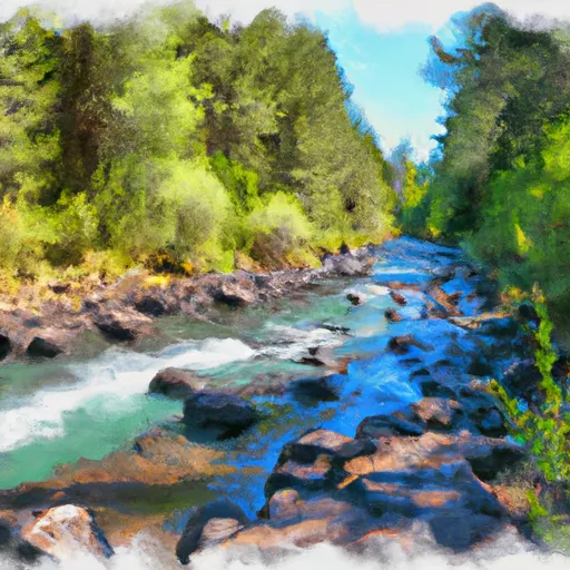
The river run covers a segment mileage of approximately 5 miles, starting at the South Fork Little Butte Creek Campground and ending at the confluence with the main Little Butte Creek. The river features numerous Class III rapids, including "The Chute," "Pinball," and "Bouncing Betty." Paddlers will also encounter boulder gardens, narrow channels, and steep drops throughout the course.
The specific regulations for this area include the need for a valid Oregon Boater Pass, which can be obtained online or at various vendors throughout the state. There are also parking restrictions at the South Fork Little Butte Creek Campground, so paddlers should plan accordingly.
Overall, the South Fork Little Butte Creek offers a challenging and exciting whitewater experience for experienced paddlers. It is important to check current streamflow levels and weather conditions before embarking on this adventure, as the river can become dangerous during periods of high water.
Plan your run down to the hour
Same weather feed Snoflo's iOS app uses -- updated continuously from NOAA / yr.no. Watch the precipitation column on the meteogram; rain ahead of a run typically lifts flows 12-48 hours later depending on the basin.
Next 5 days, hour by hour
Temperature line with weather symbols on top, snow + rain accumulation as columns, humidity as a dotted line.
5-day forecast table
Every 3 hours, broken out across temperature, snow, rain, humidity, and wind. Each cell is colour-coded relative to the column min/max.
| Time | Condition | Temp (°F) | Snow (in) | Rain (in) | Humidity (%) | Wind (mps) | Wind dir |
|---|---|---|---|---|---|---|---|
| Loading detailed forecast… | |||||||
15-day temperature & precipitation
Daily temperatures, snow, and rain projected over the next two weeks -- the upstream story that drives next week's flows.
Regional streamflow levels
USGS streamgauges around South Fork Little Butte Creek -- useful for spotting upstream pulses and gauging which tributary is contributing what.
| Streamgauge | Discharge | View |
|---|---|---|
| Klamath River Blw John C.Boyle Pwrplnt | 853 cfs | → |
| Klamath River At Keno | 654 cfs | → |
| Bear Creek Blw Ashland Creek At Ashland | 51 cfs | → |
| Sevenmile Cnl At Dike Rd Br | 23 cfs | → |
| East Fork Ashland Creek Near Ashland | 1 cfs | → |
| Wood River Near Klamath Agency | 363 cfs | → |
Plan a longer trip
The closest boat launches, other paddle runs, and campgrounds so a day on the water can grow into a full weekend.
Boat launches
- Fish Lake Resort
- Fish Lake Boating Site
- Sunset Campground
- Rainbow Bay
- Aspen Point Campground
- Grizzly Creek
Other river runs
- Antelope Creek
- Big Butte Creek (Incl South Fork Big Butte Creek)
- Headwaters To Sw1/4 Of Sec 1, T33s, R4e
- Iron Gate Dam To Happy Camp
- Sw1/4 Of Sec 1, T33s, R4e To Rogue River Nf Boundary
Campgrounds
Whitewater safety
- Check the flow before you run
- Use the linked-gauge card and Regional Flow panel above. Class ratings change with flow -- a Class III at low water can become Class IV+ at high water.
- Know your skill ceiling
- Pick runs comfortably below your ceiling. Cold-water and big-water runs raise the consequences of any mistake.
- Wear the right gear
- Helmet, PFD, drysuit / wetsuit when water is below 60°F. Throw bag, knife, and whistle on your person, not in the boat.
- Scout, set safety, and run with a team
- Scout new rapids on foot, set safety with throw bags above the consequence pool, and run with at least one other competent paddler.
- Respect the river
- Strainers, undercuts, low-head dams, and wood can kill at any class rating. When in doubt, portage.
Set push alerts in the Snoflo app
Save South Fork Little Butte Creek as a favorite, set a discharge threshold (e.g. "alert me when flow hits 600 cfs"), and the iOS app pushes the moment the linked gauge crosses.
About South Fork Little Butte Creek
What's the optimal flow for South Fork Little Butte Creek?
The optimal flow depends on the section and the craft. Check the Run Details panel for the linked gauge and current status.
How fresh is the cfs reading on this page?
The linked USGS streamgauge reports continuously (every 15 minutes); Snoflo refreshes throughout the day. Hover the streamflow sparkline to read individual datapoints.
What's the whitewater class?
See the Run Details panel for the class rating Snoflo tracks for this run. Class ratings change with flow -- a Class III at low water can become Class IV in high water.
Where do I put in / take out?
Tap Directions in the hero above to open driving directions to the put-in. For shuttle planning, check the Nearby Boat Launches panel and the river run operator's site.
Can I get alerts when flows hit the optimal range?
Yes -- alerts are managed in the Snoflo iOS app. Favorite this run, set a discharge threshold, and you'll get a push the moment the gauge crosses.
Other runs near here
Snoflo-tracked paddle runs within driving distance of South Fork Little Butte Creek.