Rock Creek Complex (Klickitat County) River Run
Community Reviews
Been here? Share the conditions.
Reviews, ratings & photos are added in the free Snoflo iOS app — rate a spot, tag the conditions, and your visit is verified by location. Add or manage your reviews from the app.
Rock Creek Complex (Klickitat County)
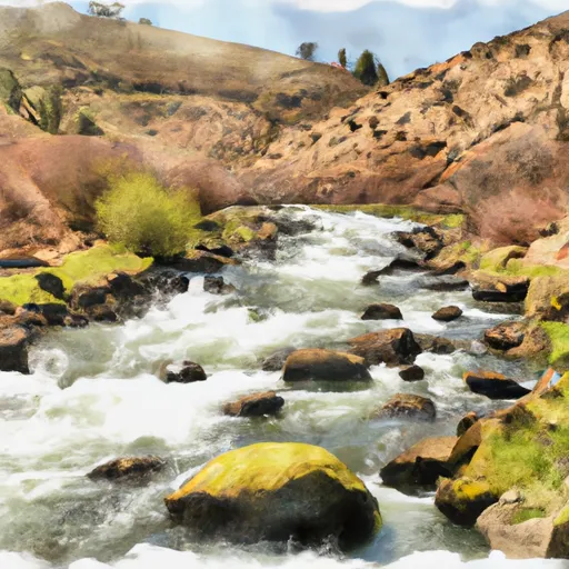
Some of the specific river rapids and obstacles to expect on this run include Boulder Drop, which is a class IV rapid with a large rock in the center of the channel. Another notable rapid is S-Turn, which is a class III rapid with a sharp left bend. Safety precautions should always be taken when navigating these rapids.
There are specific regulations to the area that all visitors must follow. The use of personal flotation devices is mandatory for all river users. Additionally, all boats must be equipped with a throwable flotation device, and all participants must wear a helmet. Camping is not permitted along the river banks, and all visitors must pack out all trash and waste.
Overall, the Rock Creek Complex offers a thrilling and challenging whitewater experience for experienced paddlers. It is important to always follow safety regulations and be prepared for the specific rapids and obstacles on this run.
Plan your run down to the hour
Same weather feed Snoflo's iOS app uses -- updated continuously from NOAA / yr.no. Watch the precipitation column on the meteogram; rain ahead of a run typically lifts flows 12-48 hours later depending on the basin.
Next 5 days, hour by hour
Temperature line with weather symbols on top, snow + rain accumulation as columns, humidity as a dotted line.
5-day forecast table
Every 3 hours, broken out across temperature, snow, rain, humidity, and wind. Each cell is colour-coded relative to the column min/max.
| Time | Condition | Temp (°F) | Snow (in) | Rain (in) | Humidity (%) | Wind (mps) | Wind dir |
|---|---|---|---|---|---|---|---|
| Loading detailed forecast… | |||||||
15-day temperature & precipitation
Daily temperatures, snow, and rain projected over the next two weeks -- the upstream story that drives next week's flows.
Regional streamflow levels
USGS streamgauges around Rock Creek Complex (Klickitat County) -- useful for spotting upstream pulses and gauging which tributary is contributing what.
| Streamgauge | Discharge | View |
|---|---|---|
| John Day River At Mcdonald Ferry | 46 cfs | → |
| Deschutes River At Moody | 3,800 cfs | → |
| Klickitat River Bl Summit Creek Near Glenwood | 1,820 cfs | → |
| Toppenish Creek Near Fort Simcoe | 6 cfs | → |
| Klickitat River Near Pitt | 728 cfs | → |
| Columbia River At The Dalles | 112,000 cfs | → |
Plan a longer trip
The closest boat launches, other paddle runs, and campgrounds so a day on the water can grow into a full weekend.
Boat launches
- Le Page Park (River Mouth)
- Rock Creek Road Klickitat County
- Philippi Park
- Railroad Island
- Giles French Park
- Sundale Park
Whitewater safety
- Check the flow before you run
- Use the linked-gauge card and Regional Flow panel above. Class ratings change with flow -- a Class III at low water can become Class IV+ at high water.
- Know your skill ceiling
- Pick runs comfortably below your ceiling. Cold-water and big-water runs raise the consequences of any mistake.
- Wear the right gear
- Helmet, PFD, drysuit / wetsuit when water is below 60°F. Throw bag, knife, and whistle on your person, not in the boat.
- Scout, set safety, and run with a team
- Scout new rapids on foot, set safety with throw bags above the consequence pool, and run with at least one other competent paddler.
- Respect the river
- Strainers, undercuts, low-head dams, and wood can kill at any class rating. When in doubt, portage.
Set push alerts in the Snoflo app
Save Rock Creek Complex (Klickitat County) as a favorite, set a discharge threshold (e.g. "alert me when flow hits 600 cfs"), and the iOS app pushes the moment the linked gauge crosses.
About Rock Creek Complex (Klickitat County)
What's the optimal flow for Rock Creek Complex (Klickitat County)?
The optimal flow depends on the section and the craft. Check the Run Details panel for the linked gauge and current status.
How fresh is the cfs reading on this page?
The linked USGS streamgauge reports continuously (every 15 minutes); Snoflo refreshes throughout the day. Hover the streamflow sparkline to read individual datapoints.
What's the whitewater class?
See the Run Details panel for the class rating Snoflo tracks for this run. Class ratings change with flow -- a Class III at low water can become Class IV in high water.
Where do I put in / take out?
Tap Directions in the hero above to open driving directions to the put-in. For shuttle planning, check the Nearby Boat Launches panel and the river run operator's site.
Can I get alerts when flows hit the optimal range?
Yes -- alerts are managed in the Snoflo iOS app. Favorite this run, set a discharge threshold, and you'll get a push the moment the gauge crosses.
Other runs near here
Snoflo-tracked paddle runs within driving distance of Rock Creek Complex (Klickitat County).