Clackamas River River Run
Community Reviews
Been here? Share the conditions.
Reviews, ratings & photos are added in the free Snoflo iOS app — rate a spot, tag the conditions, and your visit is verified by location. Add or manage your reviews from the app.
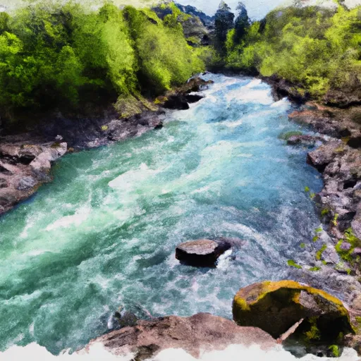
Clackamas River
The Clackamas River is classified as a Class III river, with some sections of the river reaching Class IV. The entire segment of the river run is approximately 14 miles long, beginning at Big Springs Park and ending at the North Fork Reservoir.
Some of the notable rapids and obstacles along the Clackamas River include Carter Bridge Rapid, Hole in the Wall, and Three Lynx Rapid. These rapids offer a range of challenges, including technical maneuvers, fast currents, and steep drops.
There are specific regulations in place for the Clackamas River area, including a boating permit requirement for all watercraft operating on the river. Additionally, motorized watercraft are not allowed on certain segments of the river.
Overall, the Clackamas River is a popular destination for whitewater enthusiasts seeking thrilling rapids and scenic views. It is important to follow all regulations and safety precautions when rafting or kayaking on this river to ensure a safe and enjoyable experience.
Plan your run down to the hour
Same weather feed Snoflo's iOS app uses -- updated continuously from NOAA / yr.no. Watch the precipitation column on the meteogram; rain ahead of a run typically lifts flows 12-48 hours later depending on the basin.
Next 5 days, hour by hour
Temperature line with weather symbols on top, snow + rain accumulation as columns, humidity as a dotted line.
5-day forecast table
Every 3 hours, broken out across temperature, snow, rain, humidity, and wind. Each cell is colour-coded relative to the column min/max.
| Time | Condition | Temp (°F) | Snow (in) | Rain (in) | Humidity (%) | Wind (mps) | Wind dir |
|---|---|---|---|---|---|---|---|
| Loading detailed forecast… | |||||||
15-day temperature & precipitation
Daily temperatures, snow, and rain projected over the next two weeks -- the upstream story that drives next week's flows.
Regional streamflow levels
USGS streamgauges around Clackamas River -- useful for spotting upstream pulses and gauging which tributary is contributing what.
| Streamgauge | Discharge | View |
|---|---|---|
| Clackamas River At Estacada | 655 cfs | → |
| Nate Creek Tributary Near Colton | 0 cfs | → |
| Sandy River Blw Bull Run River | 347 cfs | → |
| Little Sandy River Near Bull Run | 13 cfs | → |
| Clackamas River Near Oregon City | 711 cfs | → |
| Bull Run River Near Bull Run | 28 cfs | → |
Plan a longer trip
The closest boat launches, other paddle runs, and campgrounds so a day on the water can grow into a full weekend.
Boat launches
Other river runs
- North Section Line Of Sec 17, T4s, R5e To Slackwater North Fork Reservoir
- Headwaters To North Section Line Of Sec 17, T4s, R5e
- North Fork Clackamas River
- Sandy River
- Molalla River Seg B
Campgrounds
- Hiker/Biker Sites
- Chinook Group Camp
- Steelhead Group Camp
- Kingfisher Group Camp
- Mciver State Park
- Metzler Park
Whitewater safety
- Check the flow before you run
- Use the linked-gauge card and Regional Flow panel above. Class ratings change with flow -- a Class III at low water can become Class IV+ at high water.
- Know your skill ceiling
- Pick runs comfortably below your ceiling. Cold-water and big-water runs raise the consequences of any mistake.
- Wear the right gear
- Helmet, PFD, drysuit / wetsuit when water is below 60°F. Throw bag, knife, and whistle on your person, not in the boat.
- Scout, set safety, and run with a team
- Scout new rapids on foot, set safety with throw bags above the consequence pool, and run with at least one other competent paddler.
- Respect the river
- Strainers, undercuts, low-head dams, and wood can kill at any class rating. When in doubt, portage.
Set push alerts in the Snoflo app
Save Clackamas River as a favorite, set a discharge threshold (e.g. "alert me when flow hits 600 cfs"), and the iOS app pushes the moment the linked gauge crosses.
About Clackamas River
What's the optimal flow for Clackamas River?
The optimal flow depends on the section and the craft. Check the Run Details panel for the linked gauge and current status.
How fresh is the cfs reading on this page?
The linked USGS streamgauge reports continuously (every 15 minutes); Snoflo refreshes throughout the day. Hover the streamflow sparkline to read individual datapoints.
What's the whitewater class?
See the Run Details panel for the class rating Snoflo tracks for this run. Class ratings change with flow -- a Class III at low water can become Class IV in high water.
Where do I put in / take out?
Tap Directions in the hero above to open driving directions to the put-in. For shuttle planning, check the Nearby Boat Launches panel and the river run operator's site.
Can I get alerts when flows hit the optimal range?
Yes -- alerts are managed in the Snoflo iOS app. Favorite this run, set a discharge threshold, and you'll get a push the moment the gauge crosses.
Other runs near here
Snoflo-tracked paddle runs within driving distance of Clackamas River.