Columbia Trail, North Bonneville Boat Launch
Community Reviews
Been here? Share the conditions.
Reviews, ratings & photos are added in the free Snoflo iOS app — rate a spot, tag the conditions, and your visit is verified by location. Add or manage your reviews from the app.
Columbia Trail, North Bonneville
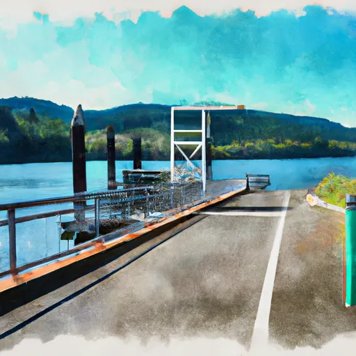
The Columbia River is a major waterway in the Pacific Northwest, which spans over 1,200 miles from its source in the Rocky Mountains of British Columbia to its mouth at the Pacific Ocean. The river is a popular destination for recreational boating, fishing, and other water sports.
According to the latest information available, the Columbia Trail boat ramp allows access to the Columbia River for a variety of watercraft, including fishing boats, kayaks, and other small boats. However, larger boats may have difficulty launching from this ramp due to its relatively narrow width.
Overall, the Columbia Trail boat ramp is a convenient and popular access point for boaters looking to enjoy the scenic beauty and recreational opportunities of the Columbia River in Oregon.
Plan your launch down to the hour
Same weather feed Snoflo's iOS app uses -- updated continuously from NOAA / yr.no.
Next 5 days, hour by hour
Temperature line with weather symbols on top, snow + rain accumulation as columns, humidity as a dotted line.
5-day forecast table
Every 3 hours, broken out across temperature, snow, rain, humidity, and wind.
| Time | Condition | Temp (°F) | Snow (in) | Rain (in) | Humidity (%) | Wind (mps) | Wind dir |
|---|---|---|---|---|---|---|---|
| Loading detailed forecast… | |||||||
15-day temperature & precipitation
Daily temperatures, snow, and rain projected over the next two weeks.
Area streamflow levels
USGS streamgauges around Columbia Trail, North Bonneville -- the same readings that determine whether your launch is safe and your boat is the right craft.
| Streamgauge | Discharge | View |
|---|---|---|
| Bull Run River Near Multnomah Falls | 53 cfs | → |
| North Fork Bull Run River Near Multnomah Falls | 12 cfs | → |
| Fir Creek Near Brightwood | 5 cfs | → |
| Bull Run River At Lower Flume Nr Brightwood | 20 cfs | → |
| Blazed Alder Creek Near Rhododendron | 4 cfs | → |
| South Fork Bull Run River Near Bull Run | 15 cfs | → |
Plan a longer trip
The closest paddle runs, fishing spots, and other boat launches so you can extend a day on the water.
River runs
- Hemlock Road Bridge To Gifford Pinchot Nf Boundary
- Headwaters In Sw1/4 Of Sec 13, T6n, R7e To Hemlock Road Bridge In Nw1/4 Of Sec 26, T4n, R7e
- Confluence Clear And Coe Creeks To Mt. Hood Nf Boundary
- Sandy River
- Headwaters In Sw 1/4 Of Sec 8, T4n, R6e To Gifford Pinchot Nf Boundary
- Mt. Hood Wilderness Boundary To Confluence With Sandy River
Boating safety & etiquette
- Check the conditions before you launch
- Use the streamflow numbers, weather, and wind forecast on this page. High-cfs whitewater requires whitewater-specific craft and skill.
- Wear your life jacket
- Statistically the single biggest survival factor in a boating incident. State law often requires one per passenger.
- File a float plan
- Tell someone on shore your put-in, take-out, and expected return time. Especially for multi-day or remote trips.
- Yield at the ramp
- Prep gear in the parking lot, not on the ramp. Launch and clear quickly so others can use the lane.
- Clean, drain, dry
- Inspect, clean, drain and dry your boat between waters to prevent the spread of aquatic invasive species.
Set push alerts in the Snoflo app
Save Columbia Trail, North Bonneville as a favorite, set a discharge threshold or a wind/precipitation alert, and the iOS app will push the moment conditions cross.
About Columbia Trail, North Bonneville
Can I launch a motorboat here?
Most Snoflo-tracked launches support motorboats; check the operator for any horsepower restrictions, paddle-only zones, or seasonal closures.
How fresh is the streamflow data?
USGS streamgauges report continuously (every 15 minutes); the table on this page pulls the latest reading at page load.
Is there a fee?
Many federal and state boat launches charge a day-use fee. Check the operator's site before driving out.
What boat is right for these conditions?
Use the nearby streamflow numbers and river-run panel on this page to gauge current conditions. Wider, slower water is friendly for casual paddling and powerboats; high-cfs whitewater requires whitewater-specific craft and skill.
Can I get alerts when conditions change?
Yes -- alerts are managed in the Snoflo iOS app. Favorite this launch, set a threshold (discharge, wind), and you'll get a push the moment it crosses.
Other launches near here
Snoflo-tracked boat launches within driving distance of Columbia Trail, North Bonneville.