Fall Creek - Eugene River Run
Community Reviews
Been here? Share the conditions.
Reviews, ratings & photos are added in the free Snoflo iOS app — rate a spot, tag the conditions, and your visit is verified by location. Add or manage your reviews from the app.
Fall Creek - Eugene
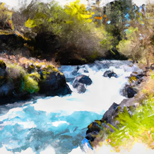
The class rating for this section of the river is Class III, with some Class IV rapids. The segment mileage is approximately 4.5 miles, starting at Dolly Varden Day Use Area and ending at Winberry Creek.
The river has several notable rapids and obstacles, including S-Turn, Pinball, and the Slot. S-Turn is a Class III rapid that requires precise maneuvering to avoid rocks in the middle of the river. Pinball is a complex rapid with multiple rocks and channels that must be navigated carefully. The Slot is a narrow chute with a steep drop that requires strong paddling skills to navigate successfully.
There are specific regulations in place for the Fall Creek section of the river. All boaters must have a valid Oregon Boater Education Card, and all rafts or kayaks must have a U.S. Coast Guard-approved personal flotation device for each person on board. Additionally, camping is only allowed in designated areas, and fires must be contained in established fire rings.
Overall, the Fall Creek section of the Whitewater River Run in Eugene, Oregon is a popular and exciting destination for experienced boaters looking for a challenging run. It is important to follow all regulations and safety protocols to ensure a safe and enjoyable experience on the river.
Plan your run down to the hour
Same weather feed Snoflo's iOS app uses -- updated continuously from NOAA / yr.no. Watch the precipitation column on the meteogram; rain ahead of a run typically lifts flows 12-48 hours later depending on the basin.
Next 5 days, hour by hour
Temperature line with weather symbols on top, snow + rain accumulation as columns, humidity as a dotted line.
5-day forecast table
Every 3 hours, broken out across temperature, snow, rain, humidity, and wind. Each cell is colour-coded relative to the column min/max.
| Time | Condition | Temp (°F) | Snow (in) | Rain (in) | Humidity (%) | Wind (mps) | Wind dir |
|---|---|---|---|---|---|---|---|
| Loading detailed forecast… | |||||||
15-day temperature & precipitation
Daily temperatures, snow, and rain projected over the next two weeks -- the upstream story that drives next week's flows.
Regional streamflow levels
USGS streamgauges around Fall Creek - Eugene -- useful for spotting upstream pulses and gauging which tributary is contributing what.
| Streamgauge | Discharge | View |
|---|---|---|
| Winberry Creek Near Lowell | 6 cfs | → |
| Fall Creek Blw Winberry Creek | 235 cfs | → |
| Mckenzie River Near Walterville | 1,760 cfs | → |
| Middle Fork Willamette River Near Dexter | 1,720 cfs | → |
| Mckenzie River Blw Leaburg Dam | 1,830 cfs | → |
| Mf Willamette River Blw N Fork | 914 cfs | → |
Plan a longer trip
The closest boat launches, other paddle runs, and campgrounds so a day on the water can grow into a full weekend.
Boat launches
- Cascara Campground
- Winberry Stae Recreation Area
- Signal Point
- North Shore Boat Ramp
- National Forest Development Road 5821 Westfir
- Lowell Park
Other river runs
- Mckenzie River Seg B
- North Fork Gate Creek
- South Fork Gate Creek
- Mckenzie River Seg A
- Below Cougar Dam To Confluence With Mckenzie River
Campgrounds
Whitewater safety
- Check the flow before you run
- Use the linked-gauge card and Regional Flow panel above. Class ratings change with flow -- a Class III at low water can become Class IV+ at high water.
- Know your skill ceiling
- Pick runs comfortably below your ceiling. Cold-water and big-water runs raise the consequences of any mistake.
- Wear the right gear
- Helmet, PFD, drysuit / wetsuit when water is below 60°F. Throw bag, knife, and whistle on your person, not in the boat.
- Scout, set safety, and run with a team
- Scout new rapids on foot, set safety with throw bags above the consequence pool, and run with at least one other competent paddler.
- Respect the river
- Strainers, undercuts, low-head dams, and wood can kill at any class rating. When in doubt, portage.
Set push alerts in the Snoflo app
Save Fall Creek - Eugene as a favorite, set a discharge threshold (e.g. "alert me when flow hits 600 cfs"), and the iOS app pushes the moment the linked gauge crosses.
About Fall Creek - Eugene
What's the optimal flow for Fall Creek - Eugene?
The optimal flow depends on the section and the craft. Check the Run Details panel for the linked gauge and current status.
How fresh is the cfs reading on this page?
The linked USGS streamgauge reports continuously (every 15 minutes); Snoflo refreshes throughout the day. Hover the streamflow sparkline to read individual datapoints.
What's the whitewater class?
See the Run Details panel for the class rating Snoflo tracks for this run. Class ratings change with flow -- a Class III at low water can become Class IV in high water.
Where do I put in / take out?
Tap Directions in the hero above to open driving directions to the put-in. For shuttle planning, check the Nearby Boat Launches panel and the river run operator's site.
Can I get alerts when flows hit the optimal range?
Yes -- alerts are managed in the Snoflo iOS app. Favorite this run, set a discharge threshold, and you'll get a push the moment the gauge crosses.
Other runs near here
Snoflo-tracked paddle runs within driving distance of Fall Creek - Eugene.