Rock Creek Complex (Klickitat County) River Run
Community Reviews
Been here? Share the conditions.
Reviews, ratings & photos are added in the free Snoflo iOS app — rate a spot, tag the conditions, and your visit is verified by location. Add or manage your reviews from the app.
Rock Creek Complex (Klickitat County)
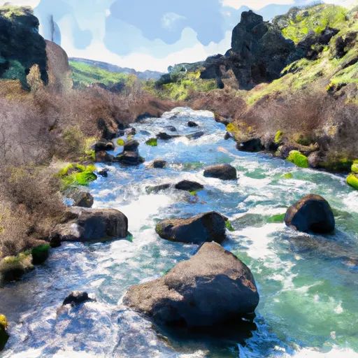
The Rock Creek Complex on the Whitewater River, located in Klickitat County, Oregon, is a popular destination for rafting and kayaking enthusiasts. The ideal streamflow range for this segment is between 800-5000 cfs, with peak season for rafting typically occurring between May and July.
The Rock Creek Complex is rated as a Class IV-V river run, featuring challenging rapids and obstacles such as the "Toilet Bowl", "The Squeeze", and "The Elevator Shaft". The segment mileage for this run is approximately 6 miles, with a put-in at the Rock Creek Campground and a take-out at the confluence with the Klickitat River.
In terms of specific regulations, boaters must obtain a permit from the Yakama Nation before accessing the river. Additionally, boaters are required to wear a personal flotation device (PFD) at all times and must adhere to Leave No Trace principles to minimize impact on the natural environment.
Overall, the Rock Creek Complex on the Whitewater River provides an exciting and challenging experience for intermediate to advanced paddlers. It is important for boaters to check current streamflow levels and obtain necessary permits before embarking on this thrilling adventure.
Plan your run down to the hour
Same weather feed Snoflo's iOS app uses -- updated continuously from NOAA / yr.no. Watch the precipitation column on the meteogram; rain ahead of a run typically lifts flows 12-48 hours later depending on the basin.
Next 5 days, hour by hour
Temperature line with weather symbols on top, snow + rain accumulation as columns, humidity as a dotted line.
5-day forecast table
Every 3 hours, broken out across temperature, snow, rain, humidity, and wind. Each cell is colour-coded relative to the column min/max.
| Time | Condition | Temp (°F) | Snow (in) | Rain (in) | Humidity (%) | Wind (mps) | Wind dir |
|---|---|---|---|---|---|---|---|
| Loading detailed forecast… | |||||||
15-day temperature & precipitation
Daily temperatures, snow, and rain projected over the next two weeks -- the upstream story that drives next week's flows.
Regional streamflow levels
USGS streamgauges around Rock Creek Complex (Klickitat County) -- useful for spotting upstream pulses and gauging which tributary is contributing what.
| Streamgauge | Discharge | View |
|---|---|---|
| John Day River At Mcdonald Ferry | 50 cfs | → |
| Deschutes River At Moody | 3,780 cfs | → |
| Klickitat River Bl Summit Creek Near Glenwood | 1,820 cfs | → |
| Toppenish Creek Near Fort Simcoe | 6 cfs | → |
| Klickitat River Near Pitt | 736 cfs | → |
| Columbia River At The Dalles | 143,000 cfs | → |
Plan a longer trip
The closest boat launches, other paddle runs, and campgrounds so a day on the water can grow into a full weekend.
Boat launches
- Rock Creek Road Klickitat County
- Le Page Park (River Mouth)
- Philippi Park
- Railroad Island
- Giles French Park
- Sundale Park
Whitewater safety
- Check the flow before you run
- Use the linked-gauge card and Regional Flow panel above. Class ratings change with flow -- a Class III at low water can become Class IV+ at high water.
- Know your skill ceiling
- Pick runs comfortably below your ceiling. Cold-water and big-water runs raise the consequences of any mistake.
- Wear the right gear
- Helmet, PFD, drysuit / wetsuit when water is below 60°F. Throw bag, knife, and whistle on your person, not in the boat.
- Scout, set safety, and run with a team
- Scout new rapids on foot, set safety with throw bags above the consequence pool, and run with at least one other competent paddler.
- Respect the river
- Strainers, undercuts, low-head dams, and wood can kill at any class rating. When in doubt, portage.
Set push alerts in the Snoflo app
Save Rock Creek Complex (Klickitat County) as a favorite, set a discharge threshold (e.g. "alert me when flow hits 600 cfs"), and the iOS app pushes the moment the linked gauge crosses.
About Rock Creek Complex (Klickitat County)
What's the optimal flow for Rock Creek Complex (Klickitat County)?
The optimal flow depends on the section and the craft. Check the Run Details panel for the linked gauge and current status.
How fresh is the cfs reading on this page?
The linked USGS streamgauge reports continuously (every 15 minutes); Snoflo refreshes throughout the day. Hover the streamflow sparkline to read individual datapoints.
What's the whitewater class?
See the Run Details panel for the class rating Snoflo tracks for this run. Class ratings change with flow -- a Class III at low water can become Class IV in high water.
Where do I put in / take out?
Tap Directions in the hero above to open driving directions to the put-in. For shuttle planning, check the Nearby Boat Launches panel and the river run operator's site.
Can I get alerts when flows hit the optimal range?
Yes -- alerts are managed in the Snoflo iOS app. Favorite this run, set a discharge threshold, and you'll get a push the moment the gauge crosses.
Other runs near here
Snoflo-tracked paddle runs within driving distance of Rock Creek Complex (Klickitat County).