Headwaters At T31s, R16e To Confluence With Colorado River River Run
Community Reviews
Been here? Share the conditions.
Reviews, ratings & photos are added in the free Snoflo iOS app — rate a spot, tag the conditions, and your visit is verified by location. Add or manage your reviews from the app.
Headwaters At T31s, R16e To Confluence With Colorado River
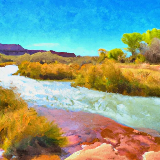
The segment mileage for this run is approximately 20 miles, starting at the Headwaters at T31S, R16E and ending at the Confluence with the Colorado River. Along the way, paddlers will encounter several challenging rapids and obstacles, including the infamous "Big Drop 2," a Class IV rapid with a steep drop and large waves.
It is important for paddlers to be aware of specific regulations in the area, including permits required for overnight camping and restrictions on fires in certain areas. It is also important to practice Leave No Trace principles and respect the local wildlife and vegetation.
Overall, the Whitewater River Run is a thrilling and challenging run for experienced paddlers looking for adventure in Utah's beautiful wilderness.
Plan your run down to the hour
Same weather feed Snoflo's iOS app uses -- updated continuously from NOAA / yr.no. Watch the precipitation column on the meteogram; rain ahead of a run typically lifts flows 12-48 hours later depending on the basin.
Next 5 days, hour by hour
Temperature line with weather symbols on top, snow + rain accumulation as columns, humidity as a dotted line.
5-day forecast table
Every 3 hours, broken out across temperature, snow, rain, humidity, and wind. Each cell is colour-coded relative to the column min/max.
| Time | Condition | Temp (°F) | Snow (in) | Rain (in) | Humidity (%) | Wind (mps) | Wind dir |
|---|---|---|---|---|---|---|---|
| Loading detailed forecast… | |||||||
15-day temperature & precipitation
Daily temperatures, snow, and rain projected over the next two weeks -- the upstream story that drives next week's flows.
Regional streamflow levels
USGS streamgauges around Headwaters At T31s, R16e To Confluence With Colorado River -- useful for spotting upstream pulses and gauging which tributary is contributing what.
| Streamgauge | Discharge | View |
|---|---|---|
| Dirty Devil R Abv Poison Sp Wash Nr Hanksville | 94 cfs | → |
| Green River At Mineral Bottom Nr Cynlnds Ntl Park | 2,380 cfs | → |
| Colorado River At Potash | 1,680 cfs | → |
| Recapture Creek Near Blanding | · | → |
| South Creek Above Reservoir Near Monticello | 0 cfs | → |
| Mill Creek Blw Pack Creek Nr Mouth At Moab | 0 cfs | → |
Plan a longer trip
The closest boat launches, other paddle runs, and campgrounds so a day on the water can grow into a full weekend.
Other river runs
- Northern Boundary Of Glen Canyon National Recreation Area To Lake Powell
- Fable Valley
- Northern Boundary Of Glen Canyon National Recreation Area To Confluence With Colorado River
Campgrounds
- Sunset Pass Campsite
- The Neck Campsite
- Teapot Rock Campsite
- Happy Canyon Campsite
- Flint Seeps Group Campsite
- Big Drop 1 Beach
Points of interest
Whitewater safety
- Check the flow before you run
- Use the linked-gauge card and Regional Flow panel above. Class ratings change with flow -- a Class III at low water can become Class IV+ at high water.
- Know your skill ceiling
- Pick runs comfortably below your ceiling. Cold-water and big-water runs raise the consequences of any mistake.
- Wear the right gear
- Helmet, PFD, drysuit / wetsuit when water is below 60°F. Throw bag, knife, and whistle on your person, not in the boat.
- Scout, set safety, and run with a team
- Scout new rapids on foot, set safety with throw bags above the consequence pool, and run with at least one other competent paddler.
- Respect the river
- Strainers, undercuts, low-head dams, and wood can kill at any class rating. When in doubt, portage.
Set push alerts in the Snoflo app
Save Headwaters At T31s, R16e To Confluence With Colorado River as a favorite, set a discharge threshold (e.g. "alert me when flow hits 600 cfs"), and the iOS app pushes the moment the linked gauge crosses.
About Headwaters At T31s, R16e To Confluence With Colorado River
What's the optimal flow for Headwaters At T31s, R16e To Confluence With Colorado River?
The optimal flow depends on the section and the craft. Check the Run Details panel for the linked gauge and current status.
How fresh is the cfs reading on this page?
The linked USGS streamgauge reports continuously (every 15 minutes); Snoflo refreshes throughout the day. Hover the streamflow sparkline to read individual datapoints.
What's the whitewater class?
See the Run Details panel for the class rating Snoflo tracks for this run. Class ratings change with flow -- a Class III at low water can become Class IV in high water.
Where do I put in / take out?
Tap Directions in the hero above to open driving directions to the put-in. For shuttle planning, check the Nearby Boat Launches panel and the river run operator's site.
Can I get alerts when flows hit the optimal range?
Yes -- alerts are managed in the Snoflo iOS app. Favorite this run, set a discharge threshold, and you'll get a push the moment the gauge crosses.
Other runs near here
Snoflo-tracked paddle runs within driving distance of Headwaters At T31s, R16e To Confluence With Colorado River.