Headwaters To Confluence With Sixth Water Creek River Run
Community Reviews
Been here? Share the conditions.
Reviews, ratings & photos are added in the free Snoflo iOS app — rate a spot, tag the conditions, and your visit is verified by location. Add or manage your reviews from the app.
Headwaters To Confluence With Sixth Water Creek
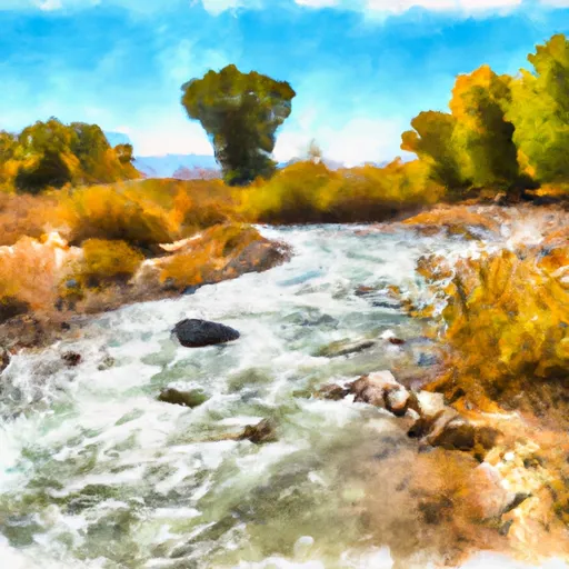
The river features several rapids, including the "Dylan's Drop," which is a class III rapid that requires precise maneuvering to avoid the rocks. Another rapid is the "Shark's Tooth," which is a class II rapid, but its tricky current can cause difficulty for beginners. The river also has several obstacles, including rock formations and fallen trees, which require navigational skill to avoid.
In terms of regulations, the river is under the jurisdiction of the National Forest Service, and a permit is required for commercial use. Participants must also wear a personal floatation device, and it is recommended to wear a helmet as well. The Utah Department of Natural Resources advises that individuals check the water level before starting the river run, as sudden changes can occur.
Overall, the Whitewater River Run from Headwaters to Confluence with Sixth Water Creek in Utah offers a challenging and scenic experience for kayakers and rafters. It is important to follow the regulations and guidelines to ensure safety on the river.
Plan your run down to the hour
Same weather feed Snoflo's iOS app uses -- updated continuously from NOAA / yr.no. Watch the precipitation column on the meteogram; rain ahead of a run typically lifts flows 12-48 hours later depending on the basin.
Next 5 days, hour by hour
Temperature line with weather symbols on top, snow + rain accumulation as columns, humidity as a dotted line.
5-day forecast table
Every 3 hours, broken out across temperature, snow, rain, humidity, and wind. Each cell is colour-coded relative to the column min/max.
| Time | Condition | Temp (°F) | Snow (in) | Rain (in) | Humidity (%) | Wind (mps) | Wind dir |
|---|---|---|---|---|---|---|---|
| Loading detailed forecast… | |||||||
15-day temperature & precipitation
Daily temperatures, snow, and rain projected over the next two weeks -- the upstream story that drives next week's flows.
Regional streamflow levels
USGS streamgauges around Headwaters To Confluence With Sixth Water Creek -- useful for spotting upstream pulses and gauging which tributary is contributing what.
| Streamgauge | Discharge | View |
|---|---|---|
| Sixth Water Cr Ab Syar Tunnel | 23 cfs | → |
| Diamond Fork Above Red Hollow | 38 cfs | → |
| Spanish Fork At Castilla | 306 cfs | → |
| Hobble Creek At 1650 West At Springville | 16 cfs | → |
| White River Bl Tabbyune C Near Soldier Summit | · | → |
| Fish Creek Above Reservoir | 2 cfs | → |
Plan a longer trip
The closest boat launches, other paddle runs, and campgrounds so a day on the water can grow into a full weekend.
Boat launches
- Renegade Point
- Strawberry Bay Recreation Complex
- Soldier Creek Recreation Complex
- Soldier Creek Dam Day Use Area
Other river runs
Fishing spots
- Bald
- Kyune Reservoir
- Gooseberry Reservoir
- Lower Gooseberry Reservoir
- Beaver Dam Reservoir Fishing Site
- Boulger Reservoir Fishing Site
Whitewater safety
- Check the flow before you run
- Use the linked-gauge card and Regional Flow panel above. Class ratings change with flow -- a Class III at low water can become Class IV+ at high water.
- Know your skill ceiling
- Pick runs comfortably below your ceiling. Cold-water and big-water runs raise the consequences of any mistake.
- Wear the right gear
- Helmet, PFD, drysuit / wetsuit when water is below 60°F. Throw bag, knife, and whistle on your person, not in the boat.
- Scout, set safety, and run with a team
- Scout new rapids on foot, set safety with throw bags above the consequence pool, and run with at least one other competent paddler.
- Respect the river
- Strainers, undercuts, low-head dams, and wood can kill at any class rating. When in doubt, portage.
Set push alerts in the Snoflo app
Save Headwaters To Confluence With Sixth Water Creek as a favorite, set a discharge threshold (e.g. "alert me when flow hits 600 cfs"), and the iOS app pushes the moment the linked gauge crosses.
About Headwaters To Confluence With Sixth Water Creek
What's the optimal flow for Headwaters To Confluence With Sixth Water Creek?
The optimal flow depends on the section and the craft. Check the Run Details panel for the linked gauge and current status.
How fresh is the cfs reading on this page?
The linked USGS streamgauge reports continuously (every 15 minutes); Snoflo refreshes throughout the day. Hover the streamflow sparkline to read individual datapoints.
What's the whitewater class?
See the Run Details panel for the class rating Snoflo tracks for this run. Class ratings change with flow -- a Class III at low water can become Class IV in high water.
Where do I put in / take out?
Tap Directions in the hero above to open driving directions to the put-in. For shuttle planning, check the Nearby Boat Launches panel and the river run operator's site.
Can I get alerts when flows hit the optimal range?
Yes -- alerts are managed in the Snoflo iOS app. Favorite this run, set a discharge threshold, and you'll get a push the moment the gauge crosses.
Other runs near here
Snoflo-tracked paddle runs within driving distance of Headwaters To Confluence With Sixth Water Creek.