Gordon Creek, South Fork River Run
Community Reviews
Been here? Share the conditions.
Reviews, ratings & photos are added in the free Snoflo iOS app — rate a spot, tag the conditions, and your visit is verified by location. Add or manage your reviews from the app.
Gordon Creek, South Fork
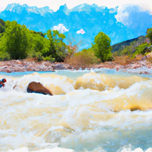
The Gordon Creek, South Fork has several challenging rapids and obstacles, including "The Squeeze," a narrow chute with a sharp turn that requires precise maneuvering, and "The Wall," a steep drop that requires a strong paddle stroke to navigate. Paddlers should also be aware of potential hazards such as strainers, fallen trees, and exposed boulders.
Specific regulations to the area include the requirement of a permit to access the river, which can be obtained from the Bureau of Land Management. Additionally, all paddlers are required to wear a personal flotation device and carry a whistle. The use of alcohol and drugs is strictly prohibited on the river.
Overall, the Gordon Creek, South Fork offers a thrilling and challenging whitewater experience for those with intermediate to advanced paddling skills. Paddlers should always be aware of potential hazards and follow regulations to ensure a safe and enjoyable trip.
Plan your run down to the hour
Same weather feed Snoflo's iOS app uses -- updated continuously from NOAA / yr.no. Watch the precipitation column on the meteogram; rain ahead of a run typically lifts flows 12-48 hours later depending on the basin.
Next 5 days, hour by hour
Temperature line with weather symbols on top, snow + rain accumulation as columns, humidity as a dotted line.
5-day forecast table
Every 3 hours, broken out across temperature, snow, rain, humidity, and wind. Each cell is colour-coded relative to the column min/max.
| Time | Condition | Temp (°F) | Snow (in) | Rain (in) | Humidity (%) | Wind (mps) | Wind dir |
|---|---|---|---|---|---|---|---|
| Loading detailed forecast… | |||||||
15-day temperature & precipitation
Daily temperatures, snow, and rain projected over the next two weeks -- the upstream story that drives next week's flows.
Regional streamflow levels
USGS streamgauges around Gordon Creek, South Fork -- useful for spotting upstream pulses and gauging which tributary is contributing what.
| Streamgauge | Discharge | View |
|---|---|---|
| Mud Creek Bl Winter Quarters Canyon At Scofield | 9 cfs | → |
| Fish Creek Above Reservoir | 12 cfs | → |
| White River Bl Tabbyune C Near Soldier Summit | · | → |
| Fairview Tunnel Near Fairview | 3 cfs | → |
| Desert Seep Wash Near Wellington | 2 cfs | → |
| Ephraim Tunnel Near Ephraim | 0 cfs | → |
Plan a longer trip
The closest boat launches, other paddle runs, and campgrounds so a day on the water can grow into a full weekend.
Campgrounds
- Price Canyon
- Price Canyon Recreation Site
- Nuck Woodward Road Trailhead
- South Hughes Group Campground
- Old Folks Flat
- Old Folks Flat Group Campground
Whitewater safety
- Check the flow before you run
- Use the linked-gauge card and Regional Flow panel above. Class ratings change with flow -- a Class III at low water can become Class IV+ at high water.
- Know your skill ceiling
- Pick runs comfortably below your ceiling. Cold-water and big-water runs raise the consequences of any mistake.
- Wear the right gear
- Helmet, PFD, drysuit / wetsuit when water is below 60°F. Throw bag, knife, and whistle on your person, not in the boat.
- Scout, set safety, and run with a team
- Scout new rapids on foot, set safety with throw bags above the consequence pool, and run with at least one other competent paddler.
- Respect the river
- Strainers, undercuts, low-head dams, and wood can kill at any class rating. When in doubt, portage.
Set push alerts in the Snoflo app
Save Gordon Creek, South Fork as a favorite, set a discharge threshold (e.g. "alert me when flow hits 600 cfs"), and the iOS app pushes the moment the linked gauge crosses.
About Gordon Creek, South Fork
What's the optimal flow for Gordon Creek, South Fork?
The optimal flow depends on the section and the craft. Check the Run Details panel for the linked gauge and current status.
How fresh is the cfs reading on this page?
The linked USGS streamgauge reports continuously (every 15 minutes); Snoflo refreshes throughout the day. Hover the streamflow sparkline to read individual datapoints.
What's the whitewater class?
See the Run Details panel for the class rating Snoflo tracks for this run. Class ratings change with flow -- a Class III at low water can become Class IV in high water.
Where do I put in / take out?
Tap Directions in the hero above to open driving directions to the put-in. For shuttle planning, check the Nearby Boat Launches panel and the river run operator's site.
Can I get alerts when flows hit the optimal range?
Yes -- alerts are managed in the Snoflo iOS app. Favorite this run, set a discharge threshold, and you'll get a push the moment the gauge crosses.
Other runs near here
Snoflo-tracked paddle runs within driving distance of Gordon Creek, South Fork.