Gordon Creek River Run
Community Reviews
Been here? Share the conditions.
Reviews, ratings & photos are added in the free Snoflo iOS app — rate a spot, tag the conditions, and your visit is verified by location. Add or manage your reviews from the app.
Gordon Creek
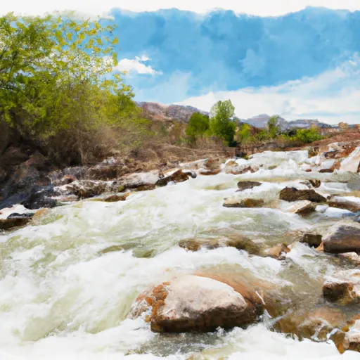
The segment mileage of Gordon Creek is approximately 10 miles long and features a variety of rapids and obstacles. Some of the most notable rapids include Happy Creek, Toilet Bowl, and the Box. Happy Creek is a technical rapid that requires precise navigation through a narrow channel, while Toilet Bowl is a steep and narrow drop that can be challenging to navigate. The Box is a scenic canyon stretch that offers a peaceful break from the more intense rapids.
There are specific regulations to the area that must be followed by all visitors. A permit is required to access the river, and camping is only allowed in designated sites. The use of motors and drones is prohibited, and visitors must pack out all trash and human waste.
In summary, Gordon Creek is a thrilling whitewater river run in Utah, with ideal streamflow between 150-500 cfs, class III-IV rapids, and a 10-mile stretch featuring various obstacles. Visitors must follow specific regulations to the area, including obtaining a permit and packing out all trash and human waste.
Plan your run down to the hour
Same weather feed Snoflo's iOS app uses -- updated continuously from NOAA / yr.no. Watch the precipitation column on the meteogram; rain ahead of a run typically lifts flows 12-48 hours later depending on the basin.
Next 5 days, hour by hour
Temperature line with weather symbols on top, snow + rain accumulation as columns, humidity as a dotted line.
5-day forecast table
Every 3 hours, broken out across temperature, snow, rain, humidity, and wind. Each cell is colour-coded relative to the column min/max.
| Time | Condition | Temp (°F) | Snow (in) | Rain (in) | Humidity (%) | Wind (mps) | Wind dir |
|---|---|---|---|---|---|---|---|
| Loading detailed forecast… | |||||||
15-day temperature & precipitation
Daily temperatures, snow, and rain projected over the next two weeks -- the upstream story that drives next week's flows.
Regional streamflow levels
USGS streamgauges around Gordon Creek -- useful for spotting upstream pulses and gauging which tributary is contributing what.
| Streamgauge | Discharge | View |
|---|---|---|
| Mud Creek Bl Winter Quarters Canyon At Scofield | 8 cfs | → |
| Fish Creek Above Reservoir | 13 cfs | → |
| White River Bl Tabbyune C Near Soldier Summit | · | → |
| Fairview Tunnel Near Fairview | 3 cfs | → |
| Desert Seep Wash Near Wellington | 2 cfs | → |
| Ephraim Tunnel Near Ephraim | 0 cfs | → |
Plan a longer trip
The closest boat launches, other paddle runs, and campgrounds so a day on the water can grow into a full weekend.
Campgrounds
- Price Canyon
- Price Canyon Recreation Site
- Nuck Woodward Road Trailhead
- Old Folks Flat
- Old Folks Flat Group Campground
- South Hughes Group Campground
Whitewater safety
- Check the flow before you run
- Use the linked-gauge card and Regional Flow panel above. Class ratings change with flow -- a Class III at low water can become Class IV+ at high water.
- Know your skill ceiling
- Pick runs comfortably below your ceiling. Cold-water and big-water runs raise the consequences of any mistake.
- Wear the right gear
- Helmet, PFD, drysuit / wetsuit when water is below 60°F. Throw bag, knife, and whistle on your person, not in the boat.
- Scout, set safety, and run with a team
- Scout new rapids on foot, set safety with throw bags above the consequence pool, and run with at least one other competent paddler.
- Respect the river
- Strainers, undercuts, low-head dams, and wood can kill at any class rating. When in doubt, portage.
Set push alerts in the Snoflo app
Save Gordon Creek as a favorite, set a discharge threshold (e.g. "alert me when flow hits 600 cfs"), and the iOS app pushes the moment the linked gauge crosses.
About Gordon Creek
What's the optimal flow for Gordon Creek?
The optimal flow depends on the section and the craft. Check the Run Details panel for the linked gauge and current status.
How fresh is the cfs reading on this page?
The linked USGS streamgauge reports continuously (every 15 minutes); Snoflo refreshes throughout the day. Hover the streamflow sparkline to read individual datapoints.
What's the whitewater class?
See the Run Details panel for the class rating Snoflo tracks for this run. Class ratings change with flow -- a Class III at low water can become Class IV in high water.
Where do I put in / take out?
Tap Directions in the hero above to open driving directions to the put-in. For shuttle planning, check the Nearby Boat Launches panel and the river run operator's site.
Can I get alerts when flows hit the optimal range?
Yes -- alerts are managed in the Snoflo iOS app. Favorite this run, set a discharge threshold, and you'll get a push the moment the gauge crosses.
Other runs near here
Snoflo-tracked paddle runs within driving distance of Gordon Creek.