Price River River Run
Community Reviews
Been here? Share the conditions.
Reviews, ratings & photos are added in the free Snoflo iOS app — rate a spot, tag the conditions, and your visit is verified by location. Add or manage your reviews from the app.
Price River
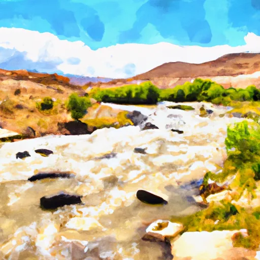
The Price River is a tributary of the Green River located in Eastern Utah, United States. The ideal streamflow range for the Price River is between 200 and 800 cubic feet per second (cfs). The river is rated as Class II-III, making it a suitable destination for intermediate kayakers and rafters. The total segment mileage of the river is approximately 40 miles, with the most popular section being a 12-mile stretch from Woodside to State Route 10.
The Price River features several notable rapids and obstacles, including the "Cable Rapid," "Waterfall Rapid," and "S-Turn Rapid." These rapids range from Class II to Class III in difficulty and provide exciting challenges for experienced boaters. The river also features scenic landscapes, including red rock formations and views of the nearby Book Cliffs.
Specific regulations to the area include a permit requirement for overnight camping on the river. Permits can be obtained from the Bureau of Land Management, who also enforces leave-no-trace principles to protect the natural environment. Additionally, boaters are required to wear a personal flotation device (PFD) at all times while on the river.
Overall, the Price River provides a thrilling whitewater experience for intermediate boaters. Its range of rapids and scenic landscapes make it a popular destination for river enthusiasts.
Plan your run down to the hour
Same weather feed Snoflo's iOS app uses -- updated continuously from NOAA / yr.no. Watch the precipitation column on the meteogram; rain ahead of a run typically lifts flows 12-48 hours later depending on the basin.
Next 5 days, hour by hour
Temperature line with weather symbols on top, snow + rain accumulation as columns, humidity as a dotted line.
5-day forecast table
Every 3 hours, broken out across temperature, snow, rain, humidity, and wind. Each cell is colour-coded relative to the column min/max.
| Time | Condition | Temp (°F) | Snow (in) | Rain (in) | Humidity (%) | Wind (mps) | Wind dir |
|---|---|---|---|---|---|---|---|
| Loading detailed forecast… | |||||||
15-day temperature & precipitation
Daily temperatures, snow, and rain projected over the next two weeks -- the upstream story that drives next week's flows.
Regional streamflow levels
USGS streamgauges around Price River -- useful for spotting upstream pulses and gauging which tributary is contributing what.
| Streamgauge | Discharge | View |
|---|---|---|
| Green River At Green River | 1,880 cfs | → |
| Price River At Woodside | 7 cfs | → |
| San Rafael River Near Green River | 4 cfs | → |
| San Rafael River At Mouth Near Green River | 13 cfs | → |
| Desert Seep Wash Near Wellington | 2 cfs | → |
| Green River At Mineral Bottom Nr Cynlnds Ntl Park | 1,740 cfs | → |
Plan a longer trip
The closest boat launches, other paddle runs, and campgrounds so a day on the water can grow into a full weekend.
Boat launches
- Nefertiti Rapid Recreation Site
- Hastings Road Grand County
- Swasey Rapid Boat Ramp Site
- Price River Put In
- South Green River Boulevard 450, Green River
- Crystal Geyser Road Grand County
Campgrounds
- Nefertiti Rapid Recreation Site
- Stone Cabin Recreation Site
- Swasey Rapid Recreation Site
- Swasey's Beach Campground
- Price River
- Green River State Park
Points of interest
Whitewater safety
- Check the flow before you run
- Use the linked-gauge card and Regional Flow panel above. Class ratings change with flow -- a Class III at low water can become Class IV+ at high water.
- Know your skill ceiling
- Pick runs comfortably below your ceiling. Cold-water and big-water runs raise the consequences of any mistake.
- Wear the right gear
- Helmet, PFD, drysuit / wetsuit when water is below 60°F. Throw bag, knife, and whistle on your person, not in the boat.
- Scout, set safety, and run with a team
- Scout new rapids on foot, set safety with throw bags above the consequence pool, and run with at least one other competent paddler.
- Respect the river
- Strainers, undercuts, low-head dams, and wood can kill at any class rating. When in doubt, portage.
Set push alerts in the Snoflo app
Save Price River as a favorite, set a discharge threshold (e.g. "alert me when flow hits 600 cfs"), and the iOS app pushes the moment the linked gauge crosses.
About Price River
What's the optimal flow for Price River?
The optimal flow depends on the section and the craft. Check the Run Details panel for the linked gauge and current status.
How fresh is the cfs reading on this page?
The linked USGS streamgauge reports continuously (every 15 minutes); Snoflo refreshes throughout the day. Hover the streamflow sparkline to read individual datapoints.
What's the whitewater class?
See the Run Details panel for the class rating Snoflo tracks for this run. Class ratings change with flow -- a Class III at low water can become Class IV in high water.
Where do I put in / take out?
Tap Directions in the hero above to open driving directions to the put-in. For shuttle planning, check the Nearby Boat Launches panel and the river run operator's site.
Can I get alerts when flows hit the optimal range?
Yes -- alerts are managed in the Snoflo iOS app. Favorite this run, set a discharge threshold, and you'll get a push the moment the gauge crosses.
Other runs near here
Snoflo-tracked paddle runs within driving distance of Price River.