Coal Wash, South Fork river run
Community Reviews
Been here? Share the conditions.
Reviews, ratings & photos are added in the free Snoflo iOS app — rate a spot, tag the conditions, and your visit is verified by location. Add or manage your reviews from the app.
Coal Wash, South Fork
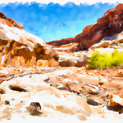
The Coal Wash, South Fork is located within the Manti-La Sal National Forest. As part of the national forest, there are specific regulations that visitors must adhere to. Visitors must obtain a permit to access the river run. The permit is available from the Manti-La Sal National Forest office. Additionally, visitors must practice Leave No Trace principles and carry out all trash and waste.
The river run provides beautiful scenery, and visitors have the opportunity to view wildlife such as bighorn sheep, mule deer, and elk. It is also a popular spot for fishing, with brown and rainbow trout being the primary catches.
In conclusion, the Coal Wash, South Fork is an exciting river run with ideal streamflow range between 200-700 cfs. It is a class II-III rapids with a segment mileage of 6.5 miles. Visitors are required to obtain a permit and follow specific regulations to protect the area. The run provides beautiful scenery and the opportunity to view wildlife and go fishing.
Plan your run down to the hour
Same weather feed Snoflo's iOS app uses -- updated continuously from NOAA / yr.no. Watch the precipitation column on the meteogram; rain ahead of a run typically lifts flows 12-48 hours later depending on the basin.
Next 5 days, hour by hour
Temperature line with weather symbols on top, snow + rain accumulation as columns, humidity as a dotted line.
5-day forecast table
Every 3 hours, broken out across temperature, snow, rain, humidity, and wind. Each cell is colour-coded relative to the column min/max.
| Time | Condition | Temp (°F) | Snow (in) | Rain (in) | Humidity (%) | Wind (mps) | Wind dir |
|---|---|---|---|---|---|---|---|
| Loading detailed forecast… | |||||||
15-day temperature & precipitation
Daily temperatures, snow, and rain projected over the next two weeks -- the upstream story that drives next week's flows.
Regional streamflow levels
USGS streamgauges around Coal Wash, South Fork -- useful for spotting upstream pulses and gauging which tributary is contributing what.
| Streamgauge | Discharge | View |
|---|---|---|
| Ferron Cr Bl Millsite Res & Divs Nr Ferron | · | → |
| Muddy Creek Near Emery | 9 cfs | → |
| Ferron Creek (Upper Station) Near Ferron | 9 cfs | → |
| San Rafael River Near Green River | · | → |
| Desert Seep Wash Near Wellington | 2 cfs | → |
| Salina Creek Near Emery | 3 cfs | → |
Plan a longer trip
The closest boat launches, other paddle runs, and campgrounds so a day on the water can grow into a full weekend.
Campgrounds
- Swaseys Cabin Recreation Site
- Wedge Overlook
- The Wickiup Site
- The Wedge Camping Area
- Swinging Bridge South Campground
- San Rafael Bridge
Whitewater safety
- Check the flow before you run
- Use the linked-gauge card and Regional Flow panel above. Class ratings change with flow -- a Class III at low water can become Class IV+ at high water.
- Know your skill ceiling
- Pick runs comfortably below your ceiling. Cold-water and big-water runs raise the consequences of any mistake.
- Wear the right gear
- Helmet, PFD, drysuit / wetsuit when water is below 60°F. Throw bag, knife, and whistle on your person, not in the boat.
- Scout, set safety, and run with a team
- Scout new rapids on foot, set safety with throw bags above the consequence pool, and run with at least one other competent paddler.
- Respect the river
- Strainers, undercuts, low-head dams, and wood can kill at any class rating. When in doubt, portage.
Set push alerts in the Snoflo app
Save Coal Wash, South Fork as a favorite, set a discharge threshold (e.g. "alert me when flow hits 600 cfs"), and the iOS app pushes the moment the linked gauge crosses.
About Coal Wash, South Fork
What's the optimal flow for Coal Wash, South Fork?
The optimal flow depends on the section and the craft. Check the Run Details panel for the linked gauge and current status.
How fresh is the cfs reading on this page?
The linked USGS streamgauge reports continuously (every 15 minutes); Snoflo refreshes throughout the day. Hover the streamflow sparkline to read individual datapoints.
What's the whitewater class?
See the Run Details panel for the class rating Snoflo tracks for this run. Class ratings change with flow -- a Class III at low water can become Class IV in high water.
Where do I put in / take out?
Tap Directions in the hero above to open driving directions to the put-in. For shuttle planning, check the Nearby Boat Launches panel and the river run operator's site.
Can I get alerts when flows hit the optimal range?
Yes -- alerts are managed in the Snoflo iOS app. Favorite this run, set a discharge threshold, and you'll get a push the moment the gauge crosses.
Other runs near here
Snoflo-tracked paddle runs within driving distance of Coal Wash, South Fork.