La Verkin Creek River Run
Community Reviews
Been here? Share the conditions.
Reviews, ratings & photos are added in the free Snoflo iOS app — rate a spot, tag the conditions, and your visit is verified by location. Add or manage your reviews from the app.
La Verkin Creek
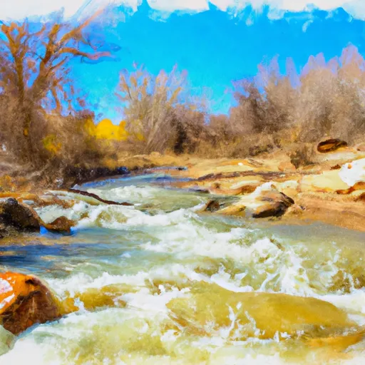
The river rapids/obstacles of La Verkin Creek include the Lower La Verkin Creek Falls, which can be seen from the river and is a beautiful sight to behold. The Box Canyon Rapid is another notable feature, consisting of a series of tight turns and drops. Additionally, the River Bed Rapid is a challenging class IV rapid that requires technical skills to navigate.
Specific regulations to the area include permits to be obtained from the National Park Service for overnight camping and hiking within the Zion National Park. River permits are required to access and run the river. Boaters must also observe Leave No Trace principles when camping and participating in river activities.
In conclusion, the La Verkin Creek is a challenging and stunning river run that offers exciting rapids and obstacles for experienced whitewater enthusiasts. Its ideal streamflow range is between 200 and 400 cfs, making it crucial to check the river's water levels before setting out. The segment mileage is approximately 6.4 miles, and specific regulations must be followed to protect the environment and the wildlife.
Plan your run down to the hour
Same weather feed Snoflo's iOS app uses -- updated continuously from NOAA / yr.no. Watch the precipitation column on the meteogram; rain ahead of a run typically lifts flows 12-48 hours later depending on the basin.
Next 5 days, hour by hour
Temperature line with weather symbols on top, snow + rain accumulation as columns, humidity as a dotted line.
5-day forecast table
Every 3 hours, broken out across temperature, snow, rain, humidity, and wind. Each cell is colour-coded relative to the column min/max.
| Time | Condition | Temp (°F) | Snow (in) | Rain (in) | Humidity (%) | Wind (mps) | Wind dir |
|---|---|---|---|---|---|---|---|
| Loading detailed forecast… | |||||||
15-day temperature & precipitation
Daily temperatures, snow, and rain projected over the next two weeks -- the upstream story that drives next week's flows.
Regional streamflow levels
USGS streamgauges around La Verkin Creek -- useful for spotting upstream pulses and gauging which tributary is contributing what.
| Streamgauge | Discharge | View |
|---|---|---|
| Leeds Creek Near Leeds | 3 cfs | → |
| Virgin River At Virgin | 55 cfs | → |
| Virgin River Ab La Verkin Creek Nr La Verkin | 36 cfs | → |
| Virgin River Ab Quail Creek Near Hurricane | 44 cfs | → |
| Virgin River Near Hurricane | 47 cfs | → |
| Santa Clara River Near Pine Valley | 6 cfs | → |
Plan a longer trip
The closest boat launches, other paddle runs, and campgrounds so a day on the water can grow into a full weekend.
Whitewater safety
- Check the flow before you run
- Use the linked-gauge card and Regional Flow panel above. Class ratings change with flow -- a Class III at low water can become Class IV+ at high water.
- Know your skill ceiling
- Pick runs comfortably below your ceiling. Cold-water and big-water runs raise the consequences of any mistake.
- Wear the right gear
- Helmet, PFD, drysuit / wetsuit when water is below 60°F. Throw bag, knife, and whistle on your person, not in the boat.
- Scout, set safety, and run with a team
- Scout new rapids on foot, set safety with throw bags above the consequence pool, and run with at least one other competent paddler.
- Respect the river
- Strainers, undercuts, low-head dams, and wood can kill at any class rating. When in doubt, portage.
Set push alerts in the Snoflo app
Save La Verkin Creek as a favorite, set a discharge threshold (e.g. "alert me when flow hits 600 cfs"), and the iOS app pushes the moment the linked gauge crosses.
About La Verkin Creek
What's the optimal flow for La Verkin Creek?
The optimal flow depends on the section and the craft. Check the Run Details panel for the linked gauge and current status.
How fresh is the cfs reading on this page?
The linked USGS streamgauge reports continuously (every 15 minutes); Snoflo refreshes throughout the day. Hover the streamflow sparkline to read individual datapoints.
What's the whitewater class?
See the Run Details panel for the class rating Snoflo tracks for this run. Class ratings change with flow -- a Class III at low water can become Class IV in high water.
Where do I put in / take out?
Tap Directions in the hero above to open driving directions to the put-in. For shuttle planning, check the Nearby Boat Launches panel and the river run operator's site.
Can I get alerts when flows hit the optimal range?
Yes -- alerts are managed in the Snoflo iOS app. Favorite this run, set a discharge threshold, and you'll get a push the moment the gauge crosses.
Other runs near here
Snoflo-tracked paddle runs within driving distance of La Verkin Creek.