Headwaters- Includes All Tributaries To Confluence With Dosewallips River River Run
Community Reviews
Been here? Share the conditions.
Reviews, ratings & photos are added in the free Snoflo iOS app — rate a spot, tag the conditions, and your visit is verified by location. Add or manage your reviews from the app.
Headwaters- Includes All Tributaries To Confluence With Dosewallips River
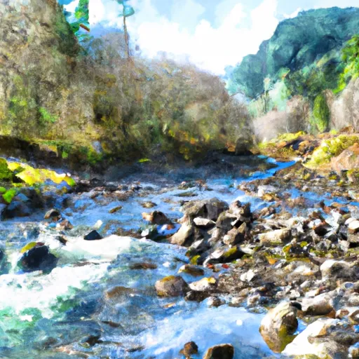
The river is rated as a class III-IV, with several rapids and obstacles along the way. Some of the notable rapids include "The Slot," "S-Turn," and "Room of Doom." The riverbed is rocky, and paddlers must navigate through tight channels and steep drops.
Specific regulations to the area include the requirement of a permit for commercial use of the river. Additionally, all boaters must wear a personal flotation device, and all watercraft must be equipped with a sound signaling device and a whistle.
In conclusion, the Whitewater River run in Washington State provides an exciting and challenging experience for paddlers. The ideal streamflow range, class rating, segment mileage, specific river rapids/obstacles, and regulations must be considered before embarking on this adventure. It is important to use multiple sources to verify accuracy and ensure safety on the river.
Plan your run down to the hour
Same weather feed Snoflo's iOS app uses -- updated continuously from NOAA / yr.no. Watch the precipitation column on the meteogram; rain ahead of a run typically lifts flows 12-48 hours later depending on the basin.
Next 5 days, hour by hour
Temperature line with weather symbols on top, snow + rain accumulation as columns, humidity as a dotted line.
5-day forecast table
Every 3 hours, broken out across temperature, snow, rain, humidity, and wind. Each cell is colour-coded relative to the column min/max.
| Time | Condition | Temp (°F) | Snow (in) | Rain (in) | Humidity (%) | Wind (mps) | Wind dir |
|---|---|---|---|---|---|---|---|
| Loading detailed forecast… | |||||||
15-day temperature & precipitation
Daily temperatures, snow, and rain projected over the next two weeks -- the upstream story that drives next week's flows.
Regional streamflow levels
USGS streamgauges around Headwaters- Includes All Tributaries To Confluence With Dosewallips River -- useful for spotting upstream pulses and gauging which tributary is contributing what.
| Streamgauge | Discharge | View |
|---|---|---|
| Duckabush River Near Brinnon | 49 cfs | → |
| Big Quilcene River Below Diversion Nr Quilcene | 26 cfs | → |
| Nf Skokomish R Bl Staircase Rpds Nr Hoodsport | 39 cfs | → |
| Dungeness River Near Sequim | 104 cfs | → |
| Elwha River Above Lake Mills Nr Port Angeles | 725 cfs | → |
| South Fork Skokomish River Near Union | 123 cfs | → |
Plan a longer trip
The closest boat launches, other paddle runs, and campgrounds so a day on the water can grow into a full weekend.
Boat launches
- Triton Cove
- Pleasant Harbor
- Mike's Beach Resort
- Indian George Creek
- Quilcene Marina
- Point Whitney Road 1099, Brinnon
Other river runs
- Confluence With Station Creek To Eastern Boundary Of Olympic National Park
- Headwaters- Includes All Tributaries (Upstream From Station Creek) To Confluence With Dosewallips River
Campgrounds
- Dosewallips Campground
- Dosewallips
- Dose Forks
- Lake Constance Campsites
- Big Timber
- Elkhorn Dispersed Campground
Parks
- Buckhorn Wilderness
- Wilderness The Brothers
- Dosewallips State Park
- Scenic Beach State Park
- Wilderness Mount Skokomish
Points of interest
Whitewater safety
- Check the flow before you run
- Use the linked-gauge card and Regional Flow panel above. Class ratings change with flow -- a Class III at low water can become Class IV+ at high water.
- Know your skill ceiling
- Pick runs comfortably below your ceiling. Cold-water and big-water runs raise the consequences of any mistake.
- Wear the right gear
- Helmet, PFD, drysuit / wetsuit when water is below 60°F. Throw bag, knife, and whistle on your person, not in the boat.
- Scout, set safety, and run with a team
- Scout new rapids on foot, set safety with throw bags above the consequence pool, and run with at least one other competent paddler.
- Respect the river
- Strainers, undercuts, low-head dams, and wood can kill at any class rating. When in doubt, portage.
Set push alerts in the Snoflo app
Save Headwaters- Includes All Tributaries To Confluence With Dosewallips River as a favorite, set a discharge threshold (e.g. "alert me when flow hits 600 cfs"), and the iOS app pushes the moment the linked gauge crosses.
About Headwaters- Includes All Tributaries To Confluence With Dosewallips River
What's the optimal flow for Headwaters- Includes All Tributaries To Confluence With Dosewallips River?
The optimal flow depends on the section and the craft. Check the Run Details panel for the linked gauge and current status.
How fresh is the cfs reading on this page?
The linked USGS streamgauge reports continuously (every 15 minutes); Snoflo refreshes throughout the day. Hover the streamflow sparkline to read individual datapoints.
What's the whitewater class?
See the Run Details panel for the class rating Snoflo tracks for this run. Class ratings change with flow -- a Class III at low water can become Class IV in high water.
Where do I put in / take out?
Tap Directions in the hero above to open driving directions to the put-in. For shuttle planning, check the Nearby Boat Launches panel and the river run operator's site.
Can I get alerts when flows hit the optimal range?
Yes -- alerts are managed in the Snoflo iOS app. Favorite this run, set a discharge threshold, and you'll get a push the moment the gauge crosses.
Other runs near here
Snoflo-tracked paddle runs within driving distance of Headwaters- Includes All Tributaries To Confluence With Dosewallips River.