Headwaters And Includes All Tributaries To Confluence With Hoh River River Run
Community Reviews
Been here? Share the conditions.
Reviews, ratings & photos are added in the free Snoflo iOS app — rate a spot, tag the conditions, and your visit is verified by location. Add or manage your reviews from the app.
Headwaters And Includes All Tributaries To Confluence With Hoh River
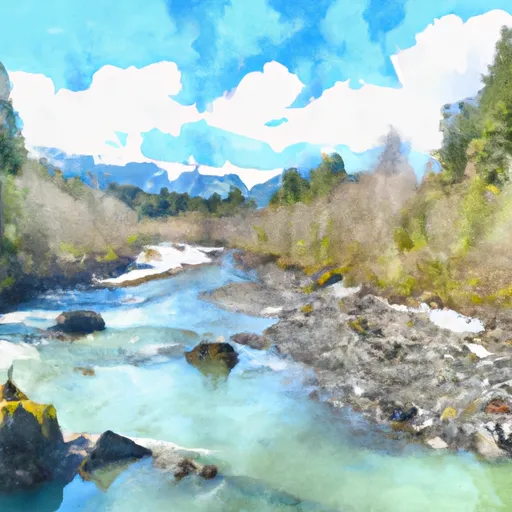
The Whitewater River run is approximately 9.5 miles long and includes all tributaries to the confluence with the Hoh River. This segment can be broken down into two distinct sections. The upper section is approximately 4 miles long and features continuous class III rapids with some class IV sections. The lower section is approximately 5.5 miles long and offers a mix of class II and III rapids.
Specific rapids and obstacles on the Whitewater River run include Boof or Consequence, Entrance Exam, and S-Turn. Boof or Consequence is a class IV rapid that requires precise navigation to avoid a large boulder in the middle of the river. Entrance Exam is a class III rapid with a narrow entrance that leads into a steep drop. S-Turn is a class III rapid with a sharp turn that requires careful maneuvering to avoid rocks and keep the boat upright.
Specific regulations for the Whitewater River run include the requirement for a permit from Olympic National Park for all commercial trips. Private boaters are not required to obtain a permit but must still adhere to all park regulations, including Leave No Trace principles. Additionally, all boaters must wear a personal flotation device (PFD) and carry a whistle and a throw bag. The use of alcohol and drugs is strictly prohibited on the river.
Plan your run down to the hour
Same weather feed Snoflo's iOS app uses -- updated continuously from NOAA / yr.no. Watch the precipitation column on the meteogram; rain ahead of a run typically lifts flows 12-48 hours later depending on the basin.
Next 5 days, hour by hour
Temperature line with weather symbols on top, snow + rain accumulation as columns, humidity as a dotted line.
5-day forecast table
Every 3 hours, broken out across temperature, snow, rain, humidity, and wind. Each cell is colour-coded relative to the column min/max.
| Time | Condition | Temp (°F) | Snow (in) | Rain (in) | Humidity (%) | Wind (mps) | Wind dir |
|---|---|---|---|---|---|---|---|
| Loading detailed forecast… | |||||||
15-day temperature & precipitation
Daily temperatures, snow, and rain projected over the next two weeks -- the upstream story that drives next week's flows.
Regional streamflow levels
USGS streamgauges around Headwaters And Includes All Tributaries To Confluence With Hoh River -- useful for spotting upstream pulses and gauging which tributary is contributing what.
| Streamgauge | Discharge | View |
|---|---|---|
| Elwha River Above Lake Mills Nr Port Angeles | 725 cfs | → |
| Elwha River At Mcdonald Br Near Port Angeles | 370 cfs | → |
| Dungeness River Near Sequim | 117 cfs | → |
| Nf Skokomish R Bl Staircase Rpds Nr Hoodsport | 46 cfs | → |
| Big Quilcene River Below Diversion Nr Quilcene | 27 cfs | → |
| Duckabush River Near Brinnon | 54 cfs | → |
Plan a longer trip
The closest boat launches, other paddle runs, and campgrounds so a day on the water can grow into a full weekend.
Other river runs
- Headwaters And Includes All Tributaries To Confluence With Elwha River
- Headwaters At 4000 Ft To Beginning Of Hoh River Trial And End Of Upper Hoh Road.
- Headwaters At About 4500 Feet In The Queets Basin From Glaciers On The Mount Olympus Massif And From The Queets Glacier On Mount Queets. To Southwestern Boundary Of Olympic National Park At End Of "Queets Corridor"
Whitewater safety
- Check the flow before you run
- Use the linked-gauge card and Regional Flow panel above. Class ratings change with flow -- a Class III at low water can become Class IV+ at high water.
- Know your skill ceiling
- Pick runs comfortably below your ceiling. Cold-water and big-water runs raise the consequences of any mistake.
- Wear the right gear
- Helmet, PFD, drysuit / wetsuit when water is below 60°F. Throw bag, knife, and whistle on your person, not in the boat.
- Scout, set safety, and run with a team
- Scout new rapids on foot, set safety with throw bags above the consequence pool, and run with at least one other competent paddler.
- Respect the river
- Strainers, undercuts, low-head dams, and wood can kill at any class rating. When in doubt, portage.
Set push alerts in the Snoflo app
Save Headwaters And Includes All Tributaries To Confluence With Hoh River as a favorite, set a discharge threshold (e.g. "alert me when flow hits 600 cfs"), and the iOS app pushes the moment the linked gauge crosses.
About Headwaters And Includes All Tributaries To Confluence With Hoh River
What's the optimal flow for Headwaters And Includes All Tributaries To Confluence With Hoh River?
The optimal flow depends on the section and the craft. Check the Run Details panel for the linked gauge and current status.
How fresh is the cfs reading on this page?
The linked USGS streamgauge reports continuously (every 15 minutes); Snoflo refreshes throughout the day. Hover the streamflow sparkline to read individual datapoints.
What's the whitewater class?
See the Run Details panel for the class rating Snoflo tracks for this run. Class ratings change with flow -- a Class III at low water can become Class IV in high water.
Where do I put in / take out?
Tap Directions in the hero above to open driving directions to the put-in. For shuttle planning, check the Nearby Boat Launches panel and the river run operator's site.
Can I get alerts when flows hit the optimal range?
Yes -- alerts are managed in the Snoflo iOS app. Favorite this run, set a discharge threshold, and you'll get a push the moment the gauge crosses.
Other runs near here
Snoflo-tracked paddle runs within driving distance of Headwaters And Includes All Tributaries To Confluence With Hoh River.