Headwaters And Includes All Tributaries To Confluence With Agnes Creek River Run
Community Reviews
Been here? Share the conditions.
Reviews, ratings & photos are added in the free Snoflo iOS app — rate a spot, tag the conditions, and your visit is verified by location. Add or manage your reviews from the app.
Headwaters And Includes All Tributaries To Confluence With Agnes Creek
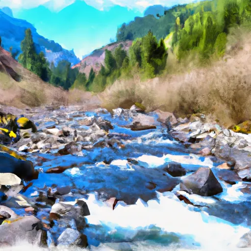
The Whitewater River Run is a popular destination for kayakers and rafters in the state of Washington. The ideal streamflow range for this run is between 500 and 2,000 cubic feet per second (cfs). The river is rated as class III-IV, making it suitable for intermediate to advanced paddlers. The run covers a distance of approximately 20 miles, from its headwaters to the confluence with Agnes Creek.
The river features several notable rapids and obstacles, including the Slide, which is a steep drop with a large boulder at the bottom, and the S-Turn, which requires precise maneuvering through a series of tight turns. Other noteworthy rapids include the Pinball, the Drop, and the Railroad Rapid.
There are specific regulations and guidelines for the Whitewater River Run, which are intended to protect the safety of paddlers and the natural environment. These include a prohibition on camping within 200 feet of the river, a requirement for all paddlers to wear a personal flotation device, and restrictions on the use of motorized watercraft. Additionally, all paddlers are advised to check local weather and streamflow conditions before embarking on the run, as conditions can change rapidly and pose significant hazards.
Overall, the Whitewater River Run is a challenging and rewarding experience for experienced paddlers. It offers a variety of rapids and obstacles, as well as breathtaking scenery and opportunities for wildlife viewing. However, it is important to approach the run with caution and respect for the river and its natural surroundings.
Plan your run down to the hour
Same weather feed Snoflo's iOS app uses -- updated continuously from NOAA / yr.no. Watch the precipitation column on the meteogram; rain ahead of a run typically lifts flows 12-48 hours later depending on the basin.
Next 5 days, hour by hour
Temperature line with weather symbols on top, snow + rain accumulation as columns, humidity as a dotted line.
5-day forecast table
Every 3 hours, broken out across temperature, snow, rain, humidity, and wind. Each cell is colour-coded relative to the column min/max.
| Time | Condition | Temp (°F) | Snow (in) | Rain (in) | Humidity (%) | Wind (mps) | Wind dir |
|---|---|---|---|---|---|---|---|
| Loading detailed forecast… | |||||||
15-day temperature & precipitation
Daily temperatures, snow, and rain projected over the next two weeks -- the upstream story that drives next week's flows.
Regional streamflow levels
USGS streamgauges around Headwaters And Includes All Tributaries To Confluence With Agnes Creek -- useful for spotting upstream pulses and gauging which tributary is contributing what.
| Streamgauge | Discharge | View |
|---|---|---|
| Salix Creek At S Cascade Gl Near Marblemount | 0 cfs | → |
| Stehekin River At Stehekin | 1,450 cfs | → |
| Sauk River Ab Whitechuck River Near Darrington | 311 cfs | → |
| Chiwawa River Near Plain | 232 cfs | → |
| Sauk River At Darrington | 5,220 cfs | → |
| Cascade River At Marblemount | 794 cfs | → |
Plan a longer trip
The closest boat launches, other paddle runs, and campgrounds so a day on the water can grow into a full weekend.
Other river runs
- Headwaters And Includes All Tributaries To Confluence With South Fork Agnes Creek
- Headwaters In Se1/4 Of Sec 25, T31n, R16e To Glacier Peak Wilderness
- Headwaters And Includes All Tributaries Including Hilgard Creek And Sable Creek To Ends 1/2 Mile Upstream Of The Confluence With The Stehekin River
Campgrounds
Parks
Whitewater safety
- Check the flow before you run
- Use the linked-gauge card and Regional Flow panel above. Class ratings change with flow -- a Class III at low water can become Class IV+ at high water.
- Know your skill ceiling
- Pick runs comfortably below your ceiling. Cold-water and big-water runs raise the consequences of any mistake.
- Wear the right gear
- Helmet, PFD, drysuit / wetsuit when water is below 60°F. Throw bag, knife, and whistle on your person, not in the boat.
- Scout, set safety, and run with a team
- Scout new rapids on foot, set safety with throw bags above the consequence pool, and run with at least one other competent paddler.
- Respect the river
- Strainers, undercuts, low-head dams, and wood can kill at any class rating. When in doubt, portage.
Set push alerts in the Snoflo app
Save Headwaters And Includes All Tributaries To Confluence With Agnes Creek as a favorite, set a discharge threshold (e.g. "alert me when flow hits 600 cfs"), and the iOS app pushes the moment the linked gauge crosses.
About Headwaters And Includes All Tributaries To Confluence With Agnes Creek
What's the optimal flow for Headwaters And Includes All Tributaries To Confluence With Agnes Creek?
The optimal flow depends on the section and the craft. Check the Run Details panel for the linked gauge and current status.
How fresh is the cfs reading on this page?
The linked USGS streamgauge reports continuously (every 15 minutes); Snoflo refreshes throughout the day. Hover the streamflow sparkline to read individual datapoints.
What's the whitewater class?
See the Run Details panel for the class rating Snoflo tracks for this run. Class ratings change with flow -- a Class III at low water can become Class IV in high water.
Where do I put in / take out?
Tap Directions in the hero above to open driving directions to the put-in. For shuttle planning, check the Nearby Boat Launches panel and the river run operator's site.
Can I get alerts when flows hit the optimal range?
Yes -- alerts are managed in the Snoflo iOS app. Favorite this run, set a discharge threshold, and you'll get a push the moment the gauge crosses.
Other runs near here
Snoflo-tracked paddle runs within driving distance of Headwaters And Includes All Tributaries To Confluence With Agnes Creek.