Headwaters And Includes All Tributaries To Confluence With Unnamed Tributaries river run
Community Reviews
Been here? Share the conditions.
Reviews, ratings & photos are added in the free Snoflo iOS app — rate a spot, tag the conditions, and your visit is verified by location. Add or manage your reviews from the app.
Headwaters And Includes All Tributaries To Confluence With Unnamed Tributaries
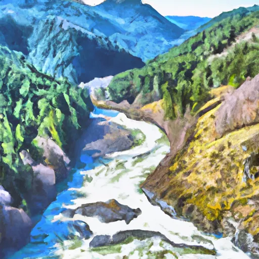
The river is rated as Class III-IV, with some challenging rapids and obstacles for experienced paddlers. The segment from the headwaters to the confluence with the North Fork is 5 miles long, while the section from the confluence with the North Fork to the confluence with the East Fork is 6 miles long. The section from the confluence with the East Fork to the confluence with the West Fork is 7 miles long.
Some of the specific rapids and obstacles on this river include "The Ledge," "The Slot," "The S-Turn," and "The Elevator." These rapids require expert precision and skill to navigate safely.
There are specific regulations in this area that paddlers need to be aware of. A permit is required for all river use, and camping is only allowed in designated areas along the river. Additionally, there are restrictions on the use of motorized boats and other watercraft in certain sections of the river.
Plan your run down to the hour
Same weather feed Snoflo's iOS app uses -- updated continuously from NOAA / yr.no. Watch the precipitation column on the meteogram; rain ahead of a run typically lifts flows 12-48 hours later depending on the basin.
Next 5 days, hour by hour
Temperature line with weather symbols on top, snow + rain accumulation as columns, humidity as a dotted line.
5-day forecast table
Every 3 hours, broken out across temperature, snow, rain, humidity, and wind. Each cell is colour-coded relative to the column min/max.
| Time | Condition | Temp (°F) | Snow (in) | Rain (in) | Humidity (%) | Wind (mps) | Wind dir |
|---|---|---|---|---|---|---|---|
| Loading detailed forecast… | |||||||
15-day temperature & precipitation
Daily temperatures, snow, and rain projected over the next two weeks -- the upstream story that drives next week's flows.
Regional streamflow levels
USGS streamgauges around Headwaters And Includes All Tributaries To Confluence With Unnamed Tributaries -- useful for spotting upstream pulses and gauging which tributary is contributing what.
| Streamgauge | Discharge | View |
|---|---|---|
| Quinault River At Quinault Lake | 481 cfs | → |
| Hoh River At Us Highway 101 Near Forks | 629 cfs | → |
| Elwha River Above Lake Mills Nr Port Angeles | 725 cfs | → |
| Queets River Near Clearwater | 542 cfs | → |
| Wynoochee River Near Grisdale | 235 cfs | → |
| Nf Skokomish R Bl Staircase Rpds Nr Hoodsport | 52 cfs | → |
Plan a longer trip
The closest boat launches, other paddle runs, and campgrounds so a day on the water can grow into a full weekend.
Boat launches
- Morgan's Crossing Jefferson County
- Morgan's Crossing Boating Site
- South Shore Road 419, Quinault
- South Shore Road 345, Quinault
Other river runs
- Headwaters And Includes All Tributaries To Confluence With Queets River
- Headwaters And Includes All Tributaries To Confluence With South Fork Hoh River
Campgrounds
Whitewater safety
- Check the flow before you run
- Use the linked-gauge card and Regional Flow panel above. Class ratings change with flow -- a Class III at low water can become Class IV+ at high water.
- Know your skill ceiling
- Pick runs comfortably below your ceiling. Cold-water and big-water runs raise the consequences of any mistake.
- Wear the right gear
- Helmet, PFD, drysuit / wetsuit when water is below 60°F. Throw bag, knife, and whistle on your person, not in the boat.
- Scout, set safety, and run with a team
- Scout new rapids on foot, set safety with throw bags above the consequence pool, and run with at least one other competent paddler.
- Respect the river
- Strainers, undercuts, low-head dams, and wood can kill at any class rating. When in doubt, portage.
Set push alerts in the Snoflo app
Save Headwaters And Includes All Tributaries To Confluence With Unnamed Tributaries as a favorite, set a discharge threshold (e.g. "alert me when flow hits 600 cfs"), and the iOS app pushes the moment the linked gauge crosses.
About Headwaters And Includes All Tributaries To Confluence With Unnamed Tributaries
What's the optimal flow for Headwaters And Includes All Tributaries To Confluence With Unnamed Tributaries?
The optimal flow depends on the section and the craft. Check the Run Details panel for the linked gauge and current status.
How fresh is the cfs reading on this page?
The linked USGS streamgauge reports continuously (every 15 minutes); Snoflo refreshes throughout the day. Hover the streamflow sparkline to read individual datapoints.
What's the whitewater class?
See the Run Details panel for the class rating Snoflo tracks for this run. Class ratings change with flow -- a Class III at low water can become Class IV in high water.
Where do I put in / take out?
Tap Directions in the hero above to open driving directions to the put-in. For shuttle planning, check the Nearby Boat Launches panel and the river run operator's site.
Can I get alerts when flows hit the optimal range?
Yes -- alerts are managed in the Snoflo iOS app. Favorite this run, set a discharge threshold, and you'll get a push the moment the gauge crosses.
Other runs near here
Snoflo-tracked paddle runs within driving distance of Headwaters And Includes All Tributaries To Confluence With Unnamed Tributaries.