Headwaters And Inlcudes All Tributaries To Confluence With South Fork Hoh River River Run
Community Reviews
Been here? Share the conditions.
Reviews, ratings & photos are added in the free Snoflo iOS app — rate a spot, tag the conditions, and your visit is verified by location. Add or manage your reviews from the app.
Headwaters And Inlcudes All Tributaries To Confluence With South Fork Hoh River
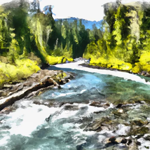
The river is rated as Class III-IV, with some of the rapids like “Crystal Creek” and “Big Brother” being Class IV. Paddlers can expect to encounter several challenging rapids, including drops and wave trains. However, the river also features deep pools and calm stretches, providing a perfect balance of adventure and relaxation.
The segment mileage of the river is broken down into three sections - Upper, Middle, and Lower. The Upper section runs for approximately 4 miles, the Middle section for 6 miles, and the Lower section for 5 miles. Each section offers a unique and exciting experience for paddlers.
The river features some specific rapids and obstacles like “The Pinch” and the “Hole in the Wall,” which require proper navigational skills and experience. Paddlers are advised to scout the rapids before running them to avoid any potential hazards.
There are specific regulations in place for the Whitewater River Run, including the requirement of a valid permit to access the river. Permits are available from the Olympic National Park Visitor Center, and all paddlers must carry appropriate safety equipment, including a PFD and a helmet.
In conclusion, the Whitewater River Run is a thrilling and challenging destination for whitewater enthusiasts in Washington. With its ideal streamflow range, class rating, specific rapids, and regulations, the river offers a safe yet exciting adventure for paddlers of all skill levels.
Plan your run down to the hour
Same weather feed Snoflo's iOS app uses -- updated continuously from NOAA / yr.no. Watch the precipitation column on the meteogram; rain ahead of a run typically lifts flows 12-48 hours later depending on the basin.
Next 5 days, hour by hour
Temperature line with weather symbols on top, snow + rain accumulation as columns, humidity as a dotted line.
5-day forecast table
Every 3 hours, broken out across temperature, snow, rain, humidity, and wind. Each cell is colour-coded relative to the column min/max.
| Time | Condition | Temp (°F) | Snow (in) | Rain (in) | Humidity (%) | Wind (mps) | Wind dir |
|---|---|---|---|---|---|---|---|
| Loading detailed forecast… | |||||||
15-day temperature & precipitation
Daily temperatures, snow, and rain projected over the next two weeks -- the upstream story that drives next week's flows.
Regional streamflow levels
USGS streamgauges around Headwaters And Inlcudes All Tributaries To Confluence With South Fork Hoh River -- useful for spotting upstream pulses and gauging which tributary is contributing what.
| Streamgauge | Discharge | View |
|---|---|---|
| Elwha River Above Lake Mills Nr Port Angeles | 725 cfs | → |
| Quinault River At Quinault Lake | 476 cfs | → |
| Hoh River At Us Highway 101 Near Forks | 602 cfs | → |
| Elwha River At Mcdonald Br Near Port Angeles | 380 cfs | → |
| Nf Skokomish R Bl Staircase Rpds Nr Hoodsport | 52 cfs | → |
| Wynoochee River Near Grisdale | 235 cfs | → |
Plan a longer trip
The closest boat launches, other paddle runs, and campgrounds so a day on the water can grow into a full weekend.
Boat launches
Other river runs
- Headwaters And Includes All Tributaries To Confluence With Queets River
- Headwaters And Includes All Tributaries To Confluence With South Fork Hoh River
- Headwaters And Includes All Tributaries To Confluence With Mount Tom Creek
- Headwaters To Confluence With Hoh River
Campgrounds
Whitewater safety
- Check the flow before you run
- Use the linked-gauge card and Regional Flow panel above. Class ratings change with flow -- a Class III at low water can become Class IV+ at high water.
- Know your skill ceiling
- Pick runs comfortably below your ceiling. Cold-water and big-water runs raise the consequences of any mistake.
- Wear the right gear
- Helmet, PFD, drysuit / wetsuit when water is below 60°F. Throw bag, knife, and whistle on your person, not in the boat.
- Scout, set safety, and run with a team
- Scout new rapids on foot, set safety with throw bags above the consequence pool, and run with at least one other competent paddler.
- Respect the river
- Strainers, undercuts, low-head dams, and wood can kill at any class rating. When in doubt, portage.
Set push alerts in the Snoflo app
Save Headwaters And Inlcudes All Tributaries To Confluence With South Fork Hoh River as a favorite, set a discharge threshold (e.g. "alert me when flow hits 600 cfs"), and the iOS app pushes the moment the linked gauge crosses.
About Headwaters And Inlcudes All Tributaries To Confluence With South Fork Hoh River
What's the optimal flow for Headwaters And Inlcudes All Tributaries To Confluence With South Fork Hoh River?
The optimal flow depends on the section and the craft. Check the Run Details panel for the linked gauge and current status.
How fresh is the cfs reading on this page?
The linked USGS streamgauge reports continuously (every 15 minutes); Snoflo refreshes throughout the day. Hover the streamflow sparkline to read individual datapoints.
What's the whitewater class?
See the Run Details panel for the class rating Snoflo tracks for this run. Class ratings change with flow -- a Class III at low water can become Class IV in high water.
Where do I put in / take out?
Tap Directions in the hero above to open driving directions to the put-in. For shuttle planning, check the Nearby Boat Launches panel and the river run operator's site.
Can I get alerts when flows hit the optimal range?
Yes -- alerts are managed in the Snoflo iOS app. Favorite this run, set a discharge threshold, and you'll get a push the moment the gauge crosses.
Other runs near here
Snoflo-tracked paddle runs within driving distance of Headwaters And Inlcudes All Tributaries To Confluence With South Fork Hoh River.