Nooksack Falls Power Plant To Fish Hatchery Near Kendall, Wa River Run
Community Reviews
Been here? Share the conditions.
Reviews, ratings & photos are added in the free Snoflo iOS app — rate a spot, tag the conditions, and your visit is verified by location. Add or manage your reviews from the app.
Nooksack Falls Power Plant To Fish Hatchery Near Kendall, Wa
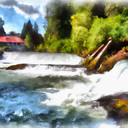
There are several notable rapids and obstacles along this segment, including "Rock Garden," "Pinball," and "Meat Grinder." The "Rock Garden" is a Class III rapid that requires precise maneuvering through a maze of boulders. "Pinball" is a Class IV rapid that features a narrow channel with numerous rocks and drops. "Meat Grinder" is another Class IV rapid that includes a wave train followed by several large boulders.
There are specific regulations in place for this segment of the river. Rafters must wear a life jacket and helmet at all times while on the river. Additionally, no alcohol or drugs are allowed on the river, and littering is strictly prohibited. Rafters must also obtain a permit from the Washington Department of Fish and Wildlife before launching their rafts.
Overall, the Nooksack Falls Power Plant to Fish Hatchery segment is a challenging and exciting whitewater run for experienced rafters. It is important to follow all regulations and safety guidelines to ensure a safe and enjoyable experience.
Plan your run down to the hour
Same weather feed Snoflo's iOS app uses -- updated continuously from NOAA / yr.no. Watch the precipitation column on the meteogram; rain ahead of a run typically lifts flows 12-48 hours later depending on the basin.
Next 5 days, hour by hour
Temperature line with weather symbols on top, snow + rain accumulation as columns, humidity as a dotted line.
5-day forecast table
Every 3 hours, broken out across temperature, snow, rain, humidity, and wind. Each cell is colour-coded relative to the column min/max.
| Time | Condition | Temp (°F) | Snow (in) | Rain (in) | Humidity (%) | Wind (mps) | Wind dir |
|---|---|---|---|---|---|---|---|
| Loading detailed forecast… | |||||||
15-day temperature & precipitation
Daily temperatures, snow, and rain projected over the next two weeks -- the upstream story that drives next week's flows.
Regional streamflow levels
USGS streamgauges around Nooksack Falls Power Plant To Fish Hatchery Near Kendall, Wa -- useful for spotting upstream pulses and gauging which tributary is contributing what.
| Streamgauge | Discharge | View |
|---|---|---|
| Racehorse Creek At North Fork Road Nr Kendall | 23 cfs | → |
| Nooksack River At North Cedarville | 1,350 cfs | → |
| Mf Nooksack River Near Deming | 212 cfs | → |
| Clearwater Creek Near Welcome | 39 cfs | → |
| Nooksack River At Everson | 1,490 cfs | → |
| Anderson Creek At Smith Road Near Goshen | 0 cfs | → |
Plan a longer trip
The closest boat launches, other paddle runs, and campgrounds so a day on the water can grow into a full weekend.
Boat launches
- Silver Lake
- Nugents Corner
- Lake Fazon
- Walmsley Avenue 31601, Abbotsford
- Mill Lake Road 32913, Mill Lake
- Sudden Valley R.V. Park And Campground
Other river runs
- Fish Hatchery To Confluence With South Fork Nooksack River
- Douglas Fir Campground To Mt. Baker Highway
- Nooksack Falls Diversion Dam To Nooksack Falls Power Plant
- Mt. Baker Wilderness Boundary To Nooksack Falls Diversion Dam
- Headwaters In Ne1/4 Of Sec 23, T37n, R7e To Confluence With Soufh Fork Nooksack River
Campgrounds
- Black Mountain Ranch
- Cocoa Crossroads
- Sumas Mtn. Outpost Cabin
- Sumas Rv Park
- Douglas Fir Campground
- Douglas Fir
Parks
- Lynden City Park
- Whatcom Falls Park
- Berthusen Memorial Park
- Cornwall Memorial Park
- Maritime Heritage Park
- Elizabeth Park
Points of interest
Whitewater safety
- Check the flow before you run
- Use the linked-gauge card and Regional Flow panel above. Class ratings change with flow -- a Class III at low water can become Class IV+ at high water.
- Know your skill ceiling
- Pick runs comfortably below your ceiling. Cold-water and big-water runs raise the consequences of any mistake.
- Wear the right gear
- Helmet, PFD, drysuit / wetsuit when water is below 60°F. Throw bag, knife, and whistle on your person, not in the boat.
- Scout, set safety, and run with a team
- Scout new rapids on foot, set safety with throw bags above the consequence pool, and run with at least one other competent paddler.
- Respect the river
- Strainers, undercuts, low-head dams, and wood can kill at any class rating. When in doubt, portage.
Set push alerts in the Snoflo app
Save Nooksack Falls Power Plant To Fish Hatchery Near Kendall, Wa as a favorite, set a discharge threshold (e.g. "alert me when flow hits 600 cfs"), and the iOS app pushes the moment the linked gauge crosses.
About Nooksack Falls Power Plant To Fish Hatchery Near Kendall, Wa
What's the optimal flow for Nooksack Falls Power Plant To Fish Hatchery Near Kendall, Wa?
The optimal flow depends on the section and the craft. Check the Run Details panel for the linked gauge and current status.
How fresh is the cfs reading on this page?
The linked USGS streamgauge reports continuously (every 15 minutes); Snoflo refreshes throughout the day. Hover the streamflow sparkline to read individual datapoints.
What's the whitewater class?
See the Run Details panel for the class rating Snoflo tracks for this run. Class ratings change with flow -- a Class III at low water can become Class IV in high water.
Where do I put in / take out?
Tap Directions in the hero above to open driving directions to the put-in. For shuttle planning, check the Nearby Boat Launches panel and the river run operator's site.
Can I get alerts when flows hit the optimal range?
Yes -- alerts are managed in the Snoflo iOS app. Favorite this run, set a discharge threshold, and you'll get a push the moment the gauge crosses.
Other runs near here
Snoflo-tracked paddle runs within driving distance of Nooksack Falls Power Plant To Fish Hatchery Near Kendall, Wa.