Outlet Of Lake Wenatchee To Wenatchee Nf Boundary River Run
Community Reviews
Been here? Share the conditions.
Reviews, ratings & photos are added in the free Snoflo iOS app — rate a spot, tag the conditions, and your visit is verified by location. Add or manage your reviews from the app.
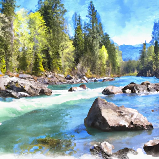
Outlet Of Lake Wenatchee To Wenatchee Nf Boundary
The total segment mileage for this run is approximately 10 miles, with notable rapids such as "Boulder Drop" and "Tinley Falls" providing challenging and exciting experiences for experienced paddlers. However, caution is advised as there are also dangerous hazards such as sweepers and strainers that can be life-threatening.
Specific regulations to the area include a requirement for all paddlers to wear a US Coast Guard-approved personal flotation device (PFD) at all times while on the river. Additionally, motorized watercraft are not allowed on this stretch of the river.
Overall, the Whitewater River Run from Outlet of Lake Wenatchee to Wenatchee NF Boundary is a thrilling and challenging destination for experienced kayakers and rafters, but safety precautions must be taken to ensure a safe and enjoyable experience.
Plan your run down to the hour
Same weather feed Snoflo's iOS app uses -- updated continuously from NOAA / yr.no. Watch the precipitation column on the meteogram; rain ahead of a run typically lifts flows 12-48 hours later depending on the basin.
Next 5 days, hour by hour
Temperature line with weather symbols on top, snow + rain accumulation as columns, humidity as a dotted line.
5-day forecast table
Every 3 hours, broken out across temperature, snow, rain, humidity, and wind. Each cell is colour-coded relative to the column min/max.
| Time | Condition | Temp (°F) | Snow (in) | Rain (in) | Humidity (%) | Wind (mps) | Wind dir |
|---|---|---|---|---|---|---|---|
| Loading detailed forecast… | |||||||
15-day temperature & precipitation
Daily temperatures, snow, and rain projected over the next two weeks -- the upstream story that drives next week's flows.
Regional streamflow levels
USGS streamgauges around Outlet Of Lake Wenatchee To Wenatchee Nf Boundary -- useful for spotting upstream pulses and gauging which tributary is contributing what.
| Streamgauge | Discharge | View |
|---|---|---|
| Wenatchee River At Peshastin | 1,010 cfs | → |
| Icicle Creek Above Snow Creek Near Leavenworth | 204 cfs | → |
| Wenatchee River At Plain | 824 cfs | → |
| Wenatchee River At Monitor | 986 cfs | → |
| Chiwawa River Near Plain | 232 cfs | → |
| Mad River At Ardenvoir | 20 cfs | → |
Plan a longer trip
The closest boat launches, other paddle runs, and campgrounds so a day on the water can grow into a full weekend.
Boat launches
- Leavenworth Public Boat Launch
- Icicle Creek
- Wenatchee River
- Dryden Dam
- Riverside Park Picnic Area
- Lower Monitor
Other river runs
- Alpine Lakes Wilderness Boundary To City Of Leavenworth Water Intake In Se1/4 Of Sec 28, T24n, R17e
- Rock Island Campground To Ida Creek
- Headwaters At Josephine Lake To Alpine Lakes Wilderness Boundary
- Glacier Peak Wilderness Boundary To Confluence With Wenatchee River
- Point At East Section Line Of Sec 13, T28n, R15e To Lake Wenatchee
Campgrounds
- Eightmile Campground
- Bridge Creek Camping
- Icicle Group Campground
- Johnny Creek
- Johnny Creek Campground
- Tumwater
Whitewater safety
- Check the flow before you run
- Use the linked-gauge card and Regional Flow panel above. Class ratings change with flow -- a Class III at low water can become Class IV+ at high water.
- Know your skill ceiling
- Pick runs comfortably below your ceiling. Cold-water and big-water runs raise the consequences of any mistake.
- Wear the right gear
- Helmet, PFD, drysuit / wetsuit when water is below 60°F. Throw bag, knife, and whistle on your person, not in the boat.
- Scout, set safety, and run with a team
- Scout new rapids on foot, set safety with throw bags above the consequence pool, and run with at least one other competent paddler.
- Respect the river
- Strainers, undercuts, low-head dams, and wood can kill at any class rating. When in doubt, portage.
Set push alerts in the Snoflo app
Save Outlet Of Lake Wenatchee To Wenatchee Nf Boundary as a favorite, set a discharge threshold (e.g. "alert me when flow hits 600 cfs"), and the iOS app pushes the moment the linked gauge crosses.
About Outlet Of Lake Wenatchee To Wenatchee Nf Boundary
What's the optimal flow for Outlet Of Lake Wenatchee To Wenatchee Nf Boundary?
The optimal flow depends on the section and the craft. Check the Run Details panel for the linked gauge and current status.
How fresh is the cfs reading on this page?
The linked USGS streamgauge reports continuously (every 15 minutes); Snoflo refreshes throughout the day. Hover the streamflow sparkline to read individual datapoints.
What's the whitewater class?
See the Run Details panel for the class rating Snoflo tracks for this run. Class ratings change with flow -- a Class III at low water can become Class IV in high water.
Where do I put in / take out?
Tap Directions in the hero above to open driving directions to the put-in. For shuttle planning, check the Nearby Boat Launches panel and the river run operator's site.
Can I get alerts when flows hit the optimal range?
Yes -- alerts are managed in the Snoflo iOS app. Favorite this run, set a discharge threshold, and you'll get a push the moment the gauge crosses.
Other runs near here
Snoflo-tracked paddle runs within driving distance of Outlet Of Lake Wenatchee To Wenatchee Nf Boundary.