Boulder River Wilderness Boundary To Confluence With Stillaguamish River river run
Community Reviews
Been here? Share the conditions.
Reviews, ratings & photos are added in the free Snoflo iOS app — rate a spot, tag the conditions, and your visit is verified by location. Add or manage your reviews from the app.
Boulder River Wilderness Boundary To Confluence With Stillaguamish River
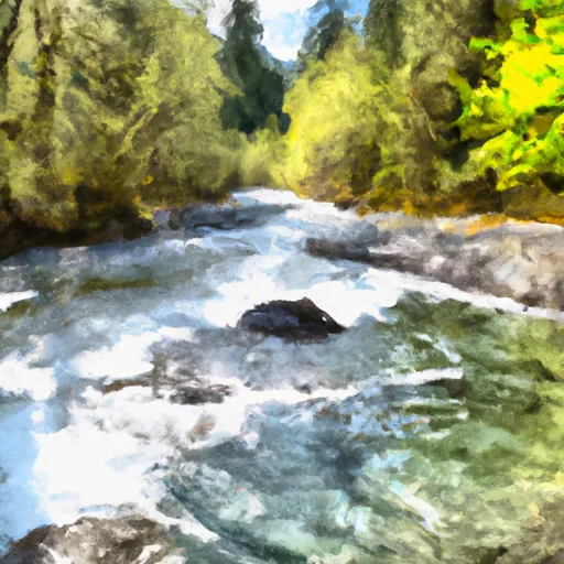
There are several specific rapids and obstacles on the Whitewater River, including "Hellhole," "S-turn," "Triple Drop," and "The Maze." These rapids range from Class III to Class IV and require technical paddling skills. Paddlers should also be aware of several log jams and sweepers that can pose hazards to navigation.
The Boulder River Wilderness area has specific regulations that must be followed by all visitors. These include rules regarding camping, campfires, and human waste disposal. The area is also closed to all motorized vehicles, including bicycles, and permits are required for overnight stays. Paddlers should also be aware of fishing regulations, as the Whitewater River is home to several species of fish, including steelhead and cutthroat trout.
Overall, the Whitewater River run in the Boulder River Wilderness area offers a challenging and rewarding paddling experience for experienced paddlers. While there are specific hazards and regulations to be aware of, the beauty and excitement of this run make it a popular destination for adventurous paddlers.
Plan your run down to the hour
Same weather feed Snoflo's iOS app uses -- updated continuously from NOAA / yr.no. Watch the precipitation column on the meteogram; rain ahead of a run typically lifts flows 12-48 hours later depending on the basin.
Next 5 days, hour by hour
Temperature line with weather symbols on top, snow + rain accumulation as columns, humidity as a dotted line.
5-day forecast table
Every 3 hours, broken out across temperature, snow, rain, humidity, and wind. Each cell is colour-coded relative to the column min/max.
| Time | Condition | Temp (°F) | Snow (in) | Rain (in) | Humidity (%) | Wind (mps) | Wind dir |
|---|---|---|---|---|---|---|---|
| Loading detailed forecast… | |||||||
15-day temperature & precipitation
Daily temperatures, snow, and rain projected over the next two weeks -- the upstream story that drives next week's flows.
Regional streamflow levels
USGS streamgauges around Boulder River Wilderness Boundary To Confluence With Stillaguamish River -- useful for spotting upstream pulses and gauging which tributary is contributing what.
| Streamgauge | Discharge | View |
|---|---|---|
| Sauk River At Darrington | 5,220 cfs | → |
| Nf Stillaguamish River Near Arlington | 276 cfs | → |
| Sauk River Near Sauk | 2,160 cfs | → |
| Sauk River Ab Whitechuck River Near Darrington | 339 cfs | → |
| Skagit River Near Concrete | 10,500 cfs | → |
| Sultan River Below Diversion Dam Near Sultan | 113 cfs | → |
Plan a longer trip
The closest boat launches, other paddle runs, and campgrounds so a day on the water can grow into a full weekend.
Boat launches
- West Lake Riley Road Snohomish County
- Lake Cavanaugh
- Lower Sauk Boat Launch
- Lake Armstrong
- White Chuck Boat Launch
- Pressentin Road 40500-40592, Concrete
Other river runs
- Headwaters In Sw1/4 Of Sec 7, T31n, R9e To Boulder River Wilderness Boundary
- Headwaters In Ne1/4 Of Sec 14, T29n, R10e To Confluence With Canyon Creek
- Glacier Peak Wilderness Boundary To Confluence With Sauk River
- Canyon Creek To Confluence With North Fork Stillaguamish River
- Glacier Peak Wilderness Boundary To Confluence With Suiattle River
Campgrounds
- Squire Creek Park & Campground
- Squire Creek County Park
- Grouse Camp Site
- Cougar Group Camp
- Doe Camp
- Cobo Camp
Whitewater safety
- Check the flow before you run
- Use the linked-gauge card and Regional Flow panel above. Class ratings change with flow -- a Class III at low water can become Class IV+ at high water.
- Know your skill ceiling
- Pick runs comfortably below your ceiling. Cold-water and big-water runs raise the consequences of any mistake.
- Wear the right gear
- Helmet, PFD, drysuit / wetsuit when water is below 60°F. Throw bag, knife, and whistle on your person, not in the boat.
- Scout, set safety, and run with a team
- Scout new rapids on foot, set safety with throw bags above the consequence pool, and run with at least one other competent paddler.
- Respect the river
- Strainers, undercuts, low-head dams, and wood can kill at any class rating. When in doubt, portage.
Set push alerts in the Snoflo app
Save Boulder River Wilderness Boundary To Confluence With Stillaguamish River as a favorite, set a discharge threshold (e.g. "alert me when flow hits 600 cfs"), and the iOS app pushes the moment the linked gauge crosses.
About Boulder River Wilderness Boundary To Confluence With Stillaguamish River
What's the optimal flow for Boulder River Wilderness Boundary To Confluence With Stillaguamish River?
The optimal flow depends on the section and the craft. Check the Run Details panel for the linked gauge and current status.
How fresh is the cfs reading on this page?
The linked USGS streamgauge reports continuously (every 15 minutes); Snoflo refreshes throughout the day. Hover the streamflow sparkline to read individual datapoints.
What's the whitewater class?
See the Run Details panel for the class rating Snoflo tracks for this run. Class ratings change with flow -- a Class III at low water can become Class IV in high water.
Where do I put in / take out?
Tap Directions in the hero above to open driving directions to the put-in. For shuttle planning, check the Nearby Boat Launches panel and the river run operator's site.
Can I get alerts when flows hit the optimal range?
Yes -- alerts are managed in the Snoflo iOS app. Favorite this run, set a discharge threshold, and you'll get a push the moment the gauge crosses.
Other runs near here
Snoflo-tracked paddle runs within driving distance of Boulder River Wilderness Boundary To Confluence With Stillaguamish River.