Segment 2 Flows For Almost 10 Miles From The Intersection With Trail 312 To Its Confluence With The Upper Priest River To Segment 2 Flows For Almost 10 Miles From The Intersection With Trail 312 To Its Confluence With The Upper Priest River River Run
Community Reviews
Been here? Share the conditions.
Reviews, ratings & photos are added in the free Snoflo iOS app — rate a spot, tag the conditions, and your visit is verified by location. Add or manage your reviews from the app.
Segment 2 Flows For Almost 10 Miles From The Intersection With Trail 312 To Its Confluence With The Upper Priest River To Segment 2 Flows For Almost 10 Miles From The Intersection With Trail 312 To Its Confluence With The Upper Priest River
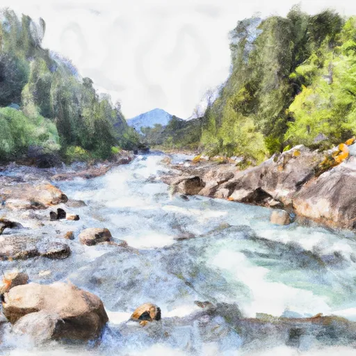
Specific regulations to the area include a permit requirement for overnight camping, as well as pack-out requirements for human waste. The area is also part of the Colville National Forest, meaning visitors should practice Leave No Trace principles and avoid damaging the natural environment. Additionally, the area is home to several species of wildlife, including bears and mountain lions, so visitors should take precautions to avoid interactions.
Plan your run down to the hour
Same weather feed Snoflo's iOS app uses -- updated continuously from NOAA / yr.no. Watch the precipitation column on the meteogram; rain ahead of a run typically lifts flows 12-48 hours later depending on the basin.
Next 5 days, hour by hour
Temperature line with weather symbols on top, snow + rain accumulation as columns, humidity as a dotted line.
5-day forecast table
Every 3 hours, broken out across temperature, snow, rain, humidity, and wind. Each cell is colour-coded relative to the column min/max.
| Time | Condition | Temp (°F) | Snow (in) | Rain (in) | Humidity (%) | Wind (mps) | Wind dir |
|---|---|---|---|---|---|---|---|
| Loading detailed forecast… | |||||||
15-day temperature & precipitation
Daily temperatures, snow, and rain projected over the next two weeks -- the upstream story that drives next week's flows.
Regional streamflow levels
USGS streamgauges around Segment 2 Flows For Almost 10 Miles From The Intersection With Trail 312 To Its Confluence With The Upper Priest River To Segment 2 Flows For Almost 10 Miles From The Intersection With Trail 312 To Its Confluence With The Upper Priest River -- useful for spotting upstream pulses and gauging which tributary is contributing what.
| Streamgauge | Discharge | View |
|---|---|---|
| Outlet Creek Near Metaline Falls | 19 cfs | → |
| Pend Oreille River Below Box Canyon Near Ione | 13,000 cfs | → |
| Boundary Creek Nr Porthill Id | 29 cfs | → |
| Kootenai River At Porthill Id | 9,950 cfs | → |
| Priest R Outflow Nr Coolin | 166 cfs | → |
| Columbia River At International Boundary | 96,700 cfs | → |
Plan a longer trip
The closest boat launches, other paddle runs, and campgrounds so a day on the water can grow into a full weekend.
Boat launches
- Priest Lake State Park - Lionhead
- Sullivan Lake Road, Metaline Falls
- Boundary Access Road, Metaline Falls
- Linton Street, Metaline
- Granite Creek Marina
- Grandview Resort
Other river runs
- Upper Priest River
- Segment 1 Is Classified As Wild And Flows From Its Source For Almost Five Miles To The Intersection With Trail 312 To Segment 1 Is Classified As Wild And Flows From Its Source For Almost To The Intersection With Trail 312
- Ne1/4 Of Sec 13, T40n, R46e To Nw1/4 Of Sec 5, T40n, R46e
- Long Canyon Pass, Sec. 30, T63n, R2w To Forest Boundary, Road #417, Sec. 25, T63n, R2w
- Forest Boundary, Sec. 34, T59n, R2w To Harrison Lake, Sec. 31, T62n, R2w
Whitewater safety
- Check the flow before you run
- Use the linked-gauge card and Regional Flow panel above. Class ratings change with flow -- a Class III at low water can become Class IV+ at high water.
- Know your skill ceiling
- Pick runs comfortably below your ceiling. Cold-water and big-water runs raise the consequences of any mistake.
- Wear the right gear
- Helmet, PFD, drysuit / wetsuit when water is below 60°F. Throw bag, knife, and whistle on your person, not in the boat.
- Scout, set safety, and run with a team
- Scout new rapids on foot, set safety with throw bags above the consequence pool, and run with at least one other competent paddler.
- Respect the river
- Strainers, undercuts, low-head dams, and wood can kill at any class rating. When in doubt, portage.
Set push alerts in the Snoflo app
Save Segment 2 Flows For Almost 10 Miles From The Intersection With Trail 312 To Its Confluence With The Upper Priest River To Segment 2 Flows For Almost 10 Miles From The Intersection With Trail 312 To Its Confluence With The Upper Priest River as a favorite, set a discharge threshold (e.g. "alert me when flow hits 600 cfs"), and the iOS app pushes the moment the linked gauge crosses.
About Segment 2 Flows For Almost 10 Miles From The Intersection With Trail 312 To Its Confluence With The Upper Priest River To Segment 2 Flows For Almost 10 Miles From The Intersection With Trail 312 To Its Confluence With The Upper Priest River
What's the optimal flow for Segment 2 Flows For Almost 10 Miles From The Intersection With Trail 312 To Its Confluence With The Upper Priest River To Segment 2 Flows For Almost 10 Miles From The Intersection With Trail 312 To Its Confluence With The Upper Priest River?
The optimal flow depends on the section and the craft. Check the Run Details panel for the linked gauge and current status.
How fresh is the cfs reading on this page?
The linked USGS streamgauge reports continuously (every 15 minutes); Snoflo refreshes throughout the day. Hover the streamflow sparkline to read individual datapoints.
What's the whitewater class?
See the Run Details panel for the class rating Snoflo tracks for this run. Class ratings change with flow -- a Class III at low water can become Class IV in high water.
Where do I put in / take out?
Tap Directions in the hero above to open driving directions to the put-in. For shuttle planning, check the Nearby Boat Launches panel and the river run operator's site.
Can I get alerts when flows hit the optimal range?
Yes -- alerts are managed in the Snoflo iOS app. Favorite this run, set a discharge threshold, and you'll get a push the moment the gauge crosses.
Other runs near here
Snoflo-tracked paddle runs within driving distance of Segment 2 Flows For Almost 10 Miles From The Intersection With Trail 312 To Its Confluence With The Upper Priest River To Segment 2 Flows For Almost 10 Miles From The Intersection With Trail 312 To Its Confluence With The Upper Priest River.