Segment 1 Is Classified As Wild And Flows From Its Source For Almost Five Miles To The Intersection With Trail 312 To Segment 1 Is Classified As Wild And Flows From Its Source For Almost To The Intersection With Trail 312 River Run
Community Reviews
Been here? Share the conditions.
Reviews, ratings & photos are added in the free Snoflo iOS app — rate a spot, tag the conditions, and your visit is verified by location. Add or manage your reviews from the app.
Segment 1 Is Classified As Wild And Flows From Its Source For Almost Five Miles To The Intersection With Trail 312 To Segment 1 Is Classified As Wild And Flows From Its Source For Almost To The Intersection With Trail 312
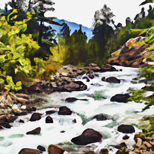
Some of the notable rapids and obstacles in this segment include the "S-Turn," which is a narrow passage with sharp turns, and "The Slide," which is a steep drop that requires precise navigation. There are also several boulder gardens and small drops scattered throughout the segment.
As for regulations, the Whitewater River Run is managed by the US Forest Service, and all visitors are required to obtain a permit before entering the area. There are also restrictions on the use of motorized watercraft, and fishing regulations are enforced to protect the native fish population.
Overall, Segment 1 of the Whitewater River Run offers an exciting and challenging experience for intermediate paddlers with moderate whitewater skills. The ideal streamflow range and Class III rating make it a popular destination for kayakers and rafters looking for an adrenaline-pumping adventure in the Pacific Northwest.
Plan your run down to the hour
Same weather feed Snoflo's iOS app uses -- updated continuously from NOAA / yr.no. Watch the precipitation column on the meteogram; rain ahead of a run typically lifts flows 12-48 hours later depending on the basin.
Next 5 days, hour by hour
Temperature line with weather symbols on top, snow + rain accumulation as columns, humidity as a dotted line.
5-day forecast table
Every 3 hours, broken out across temperature, snow, rain, humidity, and wind. Each cell is colour-coded relative to the column min/max.
| Time | Condition | Temp (°F) | Snow (in) | Rain (in) | Humidity (%) | Wind (mps) | Wind dir |
|---|---|---|---|---|---|---|---|
| Loading detailed forecast… | |||||||
15-day temperature & precipitation
Daily temperatures, snow, and rain projected over the next two weeks -- the upstream story that drives next week's flows.
Regional streamflow levels
USGS streamgauges around Segment 1 Is Classified As Wild And Flows From Its Source For Almost Five Miles To The Intersection With Trail 312 To Segment 1 Is Classified As Wild And Flows From Its Source For Almost To The Intersection With Trail 312 -- useful for spotting upstream pulses and gauging which tributary is contributing what.
| Streamgauge | Discharge | View |
|---|---|---|
| Outlet Creek Near Metaline Falls | 19 cfs | → |
| Boundary Creek Nr Porthill Id | 29 cfs | → |
| Pend Oreille River Below Box Canyon Near Ione | 13,000 cfs | → |
| Kootenai River At Porthill Id | 9,950 cfs | → |
| Columbia River At International Boundary | 96,700 cfs | → |
| Priest R Outflow Nr Coolin | 166 cfs | → |
Plan a longer trip
The closest boat launches, other paddle runs, and campgrounds so a day on the water can grow into a full weekend.
Boat launches
- Sullivan Lake Road, Metaline Falls
- Boundary Access Road, Metaline Falls
- Priest Lake State Park - Lionhead
- Linton Street, Metaline
Other river runs
- Segment 2 Flows For Almost 10 Miles From The Intersection With Trail 312 To Its Confluence With The Upper Priest River To Segment 2 Flows For Almost 10 Miles From The Intersection With Trail 312 To Its Confluence With The Upper Priest River
- Upper Priest River
- Ne1/4 Of Sec 13, T40n, R46e To Nw1/4 Of Sec 5, T40n, R46e
- Long Canyon Pass, Sec. 30, T63n, R2w To Forest Boundary, Road #417, Sec. 25, T63n, R2w
- Forest Boundary, Sec. 34, T59n, R2w To Harrison Lake, Sec. 31, T62n, R2w
Whitewater safety
- Check the flow before you run
- Use the linked-gauge card and Regional Flow panel above. Class ratings change with flow -- a Class III at low water can become Class IV+ at high water.
- Know your skill ceiling
- Pick runs comfortably below your ceiling. Cold-water and big-water runs raise the consequences of any mistake.
- Wear the right gear
- Helmet, PFD, drysuit / wetsuit when water is below 60°F. Throw bag, knife, and whistle on your person, not in the boat.
- Scout, set safety, and run with a team
- Scout new rapids on foot, set safety with throw bags above the consequence pool, and run with at least one other competent paddler.
- Respect the river
- Strainers, undercuts, low-head dams, and wood can kill at any class rating. When in doubt, portage.
Set push alerts in the Snoflo app
Save Segment 1 Is Classified As Wild And Flows From Its Source For Almost Five Miles To The Intersection With Trail 312 To Segment 1 Is Classified As Wild And Flows From Its Source For Almost To The Intersection With Trail 312 as a favorite, set a discharge threshold (e.g. "alert me when flow hits 600 cfs"), and the iOS app pushes the moment the linked gauge crosses.
About Segment 1 Is Classified As Wild And Flows From Its Source For Almost Five Miles To The Intersection With Trail 312 To Segment 1 Is Classified As Wild And Flows From Its Source For Almost To The Intersection With Trail 312
What's the optimal flow for Segment 1 Is Classified As Wild And Flows From Its Source For Almost Five Miles To The Intersection With Trail 312 To Segment 1 Is Classified As Wild And Flows From Its Source For Almost To The Intersection With Trail 312?
The optimal flow depends on the section and the craft. Check the Run Details panel for the linked gauge and current status.
How fresh is the cfs reading on this page?
The linked USGS streamgauge reports continuously (every 15 minutes); Snoflo refreshes throughout the day. Hover the streamflow sparkline to read individual datapoints.
What's the whitewater class?
See the Run Details panel for the class rating Snoflo tracks for this run. Class ratings change with flow -- a Class III at low water can become Class IV in high water.
Where do I put in / take out?
Tap Directions in the hero above to open driving directions to the put-in. For shuttle planning, check the Nearby Boat Launches panel and the river run operator's site.
Can I get alerts when flows hit the optimal range?
Yes -- alerts are managed in the Snoflo iOS app. Favorite this run, set a discharge threshold, and you'll get a push the moment the gauge crosses.
Other runs near here
Snoflo-tracked paddle runs within driving distance of Segment 1 Is Classified As Wild And Flows From Its Source For Almost Five Miles To The Intersection With Trail 312 To Segment 1 Is Classified As Wild And Flows From Its Source For Almost To The Intersection With Trail 312.