Source To Confluence With Green River river run
Community Reviews
Been here? Share the conditions.
Reviews, ratings & photos are added in the free Snoflo iOS app — rate a spot, tag the conditions, and your visit is verified by location. Add or manage your reviews from the app.
Source To Confluence With Green River
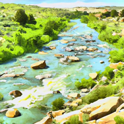
The Whitewater River Run has several specific rapids and obstacles, including the Sleeping Giant, a long and steep rapid that requires excellent maneuvering skills, and The Slide, a large and steep drop that requires precise navigation. The river also has several obstacles in the form of rocks and boulders that require careful navigation.
To ensure safe and responsible use of the area, there are specific regulations in place. A permit is required to access the area, and users must follow all rules and regulations set by the Bureau of Land Management. The use of personal flotation devices is mandatory, and users must follow Leave No Trace principles to protect the natural environment.
Overall, the Whitewater River Run is a thrilling adventure for experienced paddlers who enjoy challenging rapids and obstacles. It is essential to follow all regulations and safety precautions to ensure a safe and enjoyable experience. Sources used to verify this information include American Whitewater and the Bureau of Land Management.
Plan your run down to the hour
Same weather feed Snoflo's iOS app uses -- updated continuously from NOAA / yr.no. Watch the precipitation column on the meteogram; rain ahead of a run typically lifts flows 12-48 hours later depending on the basin.
Next 5 days, hour by hour
Temperature line with weather symbols on top, snow + rain accumulation as columns, humidity as a dotted line.
5-day forecast table
Every 3 hours, broken out across temperature, snow, rain, humidity, and wind. Each cell is colour-coded relative to the column min/max.
| Time | Condition | Temp (°F) | Snow (in) | Rain (in) | Humidity (%) | Wind (mps) | Wind dir |
|---|---|---|---|---|---|---|---|
| Loading detailed forecast… | |||||||
15-day temperature & precipitation
Daily temperatures, snow, and rain projected over the next two weeks -- the upstream story that drives next week's flows.
Regional streamflow levels
USGS streamgauges around Source To Confluence With Green River -- useful for spotting upstream pulses and gauging which tributary is contributing what.
| Streamgauge | Discharge | View |
|---|---|---|
| Wind River Near Dubois | 165 cfs | → |
| Wind River Above Red Creek | 860 cfs | → |
| Pine Creek Above Fremont Lake | 347 cfs | → |
| Dinwoody Creek Above Lakes | 437 cfs | → |
| Green River At Warren Bridge | 924 cfs | → |
| Bull Lake Creek Above Bull Lake | 693 cfs | → |
Plan a longer trip
The closest boat launches, other paddle runs, and campgrounds so a day on the water can grow into a full weekend.
Boat launches
Other river runs
- Forest Road To Confluence With Green River
- Source To End Of Forest Road
- Source, Green River Pass To Lower Green River Lake
- Lower Green River Lake Outlet To Nf Boundary
- Warm Springs Creek
Campgrounds
- Green River Lake Campground
- Green River Lake Group Campground
- Green River Lake Lodge
- Green River Lake
- Whiskey Grove Campground
- Whiskey Grove
Fishing spots
Whitewater safety
- Check the flow before you run
- Use the linked-gauge card and Regional Flow panel above. Class ratings change with flow -- a Class III at low water can become Class IV+ at high water.
- Know your skill ceiling
- Pick runs comfortably below your ceiling. Cold-water and big-water runs raise the consequences of any mistake.
- Wear the right gear
- Helmet, PFD, drysuit / wetsuit when water is below 60°F. Throw bag, knife, and whistle on your person, not in the boat.
- Scout, set safety, and run with a team
- Scout new rapids on foot, set safety with throw bags above the consequence pool, and run with at least one other competent paddler.
- Respect the river
- Strainers, undercuts, low-head dams, and wood can kill at any class rating. When in doubt, portage.
Set push alerts in the Snoflo app
Save Source To Confluence With Green River as a favorite, set a discharge threshold (e.g. "alert me when flow hits 600 cfs"), and the iOS app pushes the moment the linked gauge crosses.
About Source To Confluence With Green River
What's the optimal flow for Source To Confluence With Green River?
The optimal flow depends on the section and the craft. Check the Run Details panel for the linked gauge and current status.
How fresh is the cfs reading on this page?
The linked USGS streamgauge reports continuously (every 15 minutes); Snoflo refreshes throughout the day. Hover the streamflow sparkline to read individual datapoints.
What's the whitewater class?
See the Run Details panel for the class rating Snoflo tracks for this run. Class ratings change with flow -- a Class III at low water can become Class IV in high water.
Where do I put in / take out?
Tap Directions in the hero above to open driving directions to the put-in. For shuttle planning, check the Nearby Boat Launches panel and the river run operator's site.
Can I get alerts when flows hit the optimal range?
Yes -- alerts are managed in the Snoflo iOS app. Favorite this run, set a discharge threshold, and you'll get a push the moment the gauge crosses.
Other runs near here
Snoflo-tracked paddle runs within driving distance of Source To Confluence With Green River.