Trailhead To Confluence With Greys River River Run
Community Reviews
Been here? Share the conditions.
Reviews, ratings & photos are added in the free Snoflo iOS app — rate a spot, tag the conditions, and your visit is verified by location. Add or manage your reviews from the app.
Trailhead To Confluence With Greys River
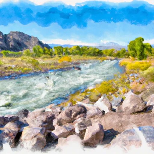
The segment mileage for this section is approximately 8 miles, starting at the Whitewater River Trailhead and ending at the confluence with Greys River. Some of the notable rapids and obstacles along this stretch include the Rock Garden, S-Turn, and the Narrows. These rapids require specific techniques and maneuvers to navigate safely.
It is essential to note that there are specific regulations to the area that need to be followed. The use of personal flotation devices (PFDs) is mandatory for all people in and around the river. Additionally, there are restrictions on the use of motorized boats and fishing in some areas. Visitors are encouraged to familiarize themselves with these regulations before embarking on their trip.
In conclusion, the Whitewater River Run Trailhead to Confluence with Greys River is a challenging and exciting whitewater adventure that requires advanced skills and experience. Visitors should ensure they have the necessary equipment, including PFDs, and adhere to all regulations to ensure a safe and enjoyable trip.
Plan your run down to the hour
Same weather feed Snoflo's iOS app uses -- updated continuously from NOAA / yr.no. Watch the precipitation column on the meteogram; rain ahead of a run typically lifts flows 12-48 hours later depending on the basin.
Next 5 days, hour by hour
Temperature line with weather symbols on top, snow + rain accumulation as columns, humidity as a dotted line.
5-day forecast table
Every 3 hours, broken out across temperature, snow, rain, humidity, and wind. Each cell is colour-coded relative to the column min/max.
| Time | Condition | Temp (°F) | Snow (in) | Rain (in) | Humidity (%) | Wind (mps) | Wind dir |
|---|---|---|---|---|---|---|---|
| Loading detailed forecast… | |||||||
15-day temperature & precipitation
Daily temperatures, snow, and rain projected over the next two weeks -- the upstream story that drives next week's flows.
Regional streamflow levels
USGS streamgauges around Trailhead To Confluence With Greys River -- useful for spotting upstream pulses and gauging which tributary is contributing what.
| Streamgauge | Discharge | View |
|---|---|---|
| Snake River Ab Reservoir Nr Alpine Wy | 7,280 cfs | → |
| Greys River Ab Reservoir Nr Alpine Wy | 419 cfs | → |
| Salt River Ab Reservoir Nr Etna Wy | 328 cfs | → |
| Snake River Bl Flat Creek Nr Jackson Wy | 7,330 cfs | → |
| Cache Creek Near Jackson | 14 cfs | → |
| Flat Creek Bel Cache Creek | 209 cfs | → |
Plan a longer trip
The closest boat launches, other paddle runs, and campgrounds so a day on the water can grow into a full weekend.
Boat launches
- Snake River
- West Table Boating Site
- East Table Boating Site
- Taco Hole Kayak Access
- Sheep Gulch Boating Site
- King's Wave Kayak Access
Other river runs
- Source To Trailhead
- Source, Pickle Pass To Confluence With Hoback River
- Upper Greys (Murphy Creek Bridge To Lynx Creek Campground)
- Upper Greys (Lynx Creek To Little Greys)
Campgrounds
- Hunting Camp
- Mccain Guard Station
- Waterdog Lake Hunting Camp
- Deer Creek Guard Station
- Murphy Creek Campground
Fishing spots
Whitewater safety
- Check the flow before you run
- Use the linked-gauge card and Regional Flow panel above. Class ratings change with flow -- a Class III at low water can become Class IV+ at high water.
- Know your skill ceiling
- Pick runs comfortably below your ceiling. Cold-water and big-water runs raise the consequences of any mistake.
- Wear the right gear
- Helmet, PFD, drysuit / wetsuit when water is below 60°F. Throw bag, knife, and whistle on your person, not in the boat.
- Scout, set safety, and run with a team
- Scout new rapids on foot, set safety with throw bags above the consequence pool, and run with at least one other competent paddler.
- Respect the river
- Strainers, undercuts, low-head dams, and wood can kill at any class rating. When in doubt, portage.
Set push alerts in the Snoflo app
Save Trailhead To Confluence With Greys River as a favorite, set a discharge threshold (e.g. "alert me when flow hits 600 cfs"), and the iOS app pushes the moment the linked gauge crosses.
About Trailhead To Confluence With Greys River
What's the optimal flow for Trailhead To Confluence With Greys River?
The optimal flow depends on the section and the craft. Check the Run Details panel for the linked gauge and current status.
How fresh is the cfs reading on this page?
The linked USGS streamgauge reports continuously (every 15 minutes); Snoflo refreshes throughout the day. Hover the streamflow sparkline to read individual datapoints.
What's the whitewater class?
See the Run Details panel for the class rating Snoflo tracks for this run. Class ratings change with flow -- a Class III at low water can become Class IV in high water.
Where do I put in / take out?
Tap Directions in the hero above to open driving directions to the put-in. For shuttle planning, check the Nearby Boat Launches panel and the river run operator's site.
Can I get alerts when flows hit the optimal range?
Yes -- alerts are managed in the Snoflo iOS app. Favorite this run, set a discharge threshold, and you'll get a push the moment the gauge crosses.
Other runs near here
Snoflo-tracked paddle runs within driving distance of Trailhead To Confluence With Greys River.